
WARM OCTOBER NOVEMBER EQUALS WARMER WINTER?

WARM OCTOBER NOVEMBER EQUALS WARMER WINTER?
Winter weather lovers are wondering what if anything the warm October means going forward with regards to the winter. The stats on this really don’t have much value however when you combine a warmer than average October with a warmer than average November you do get some evidence that it leads to a warmer winter with below average snowfall
THANKS TO MY FRIEND TONY GIGI FOR THESE STATISTICS
WARM OCTOBER NOVEMBER EQUALS WARMER WINTERS LESS SNOW
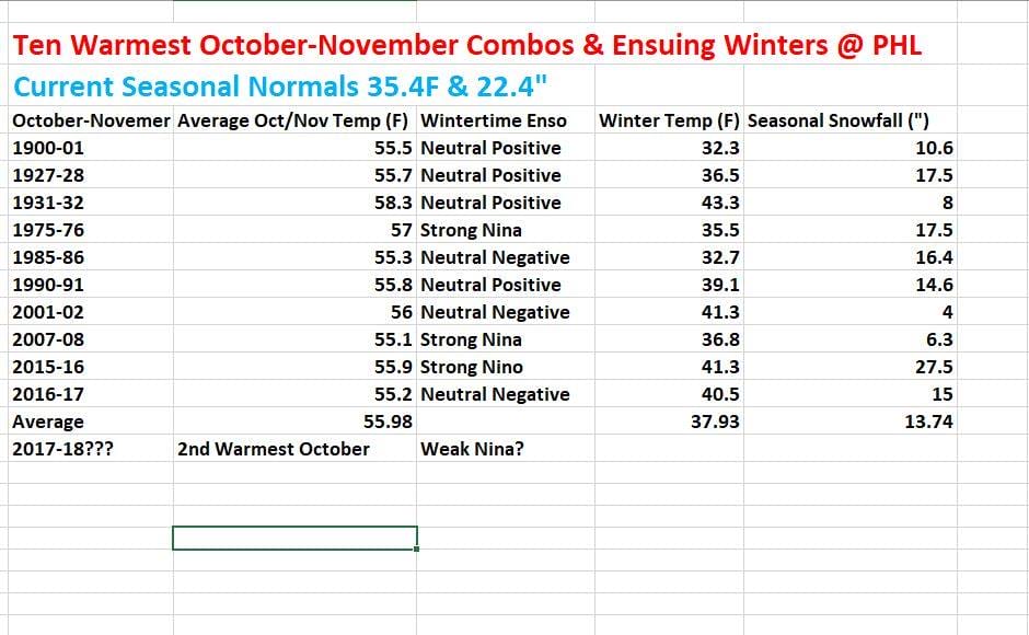
In Philadelphia at least the statistics going back to 1900 are rather convincing. Looking at the warmer October November combinations of which there are 10 of then, it has resulted in below average snowfall in 9 of the 10 winters. With regards to temperatures it produced only 2 winters where the temperatures were below average with one right at average. Granted there are other factors involved and the sample is rather small with just 10 winters meeting the cut. 1 winter had a strong el nino and 2 had strong la nina conditions. The rest were neutral with a nino/nina bias in both directions. Also we are talking about 1 specific point here and not an entire region. For example last winter which was warmer than average did produce above average snowfall for the winter if you resided north of 40 degrees north and through Northern Pennsylvania northeast to New England. It also doesn’t mean there can’t be the one big snowstorm that drives the entire winter snowfall like in 2015-16 and the blizzard of 2016. It is food for thought going forward as we see 70 degree readings in the forecast for the next 2 days and probably next Monday.
JET STREAM PATTERN NEXT WEEK

The pattern seems to be setting up with more variability going forward. Weather models are trending toward a colder look next week with troughing in the East and off the west coast with a generally colder look to it. Whether this is another temporary shift or something that lasts longer remains to be seen.
ESCAPE THE WINTER WITH A CRUISE!
MANY THANKS TO TROPICAL TIDBITS FOR THE WONDERFUL USE OF THE MAPS

GET JOE A CIGAR IF YOU LIKE!
FiOS1 News Weather Forecast For Long Island
FiOS1 News Weather Forecast For New Jersey
FiOS1 News Weather Forecast For Hudson Valley
NATIONAL WEATHER SERVICE SNOW FORECASTS
LATEST JOESTRADAMUS ON THE LONG RANGE
Weather App

Don’t be without Meteorologist Joe Cioffi’s weather app. It is really a meteorologist app because you get my forecasts and my analysis and not some automated computer generated forecast based on the GFS model. This is why your app forecast changes every 6 hours. It is model driven with no human input at all. It gives you an icon, a temperature and no insight whatsoever.
It is a complete weather app to suit your forecast needs. All the weather information you need is right on your phone. Android or I-phone, use it to keep track of all the latest weather information and forecasts. This weather app is also free of advertising so you don’t have to worry about security issues with your device. An accurate forecast and no worries that your device is being compromised.
Use it in conjunction with my website and my facebook and twitter and you have complete weather coverage of all the latest weather and the long range outlook. The website has been redone and upgraded. Its easy to use and everything is archived so you can see how well Joe does or doesn’t do when it comes to forecasts and outlooks.
Just click on the google play button or the apple store button on the sidebar for my app which is on My Weather Concierge. Download the app for free. Subscribe to my forecasts on an ad free environment for just 99 cents a month.
Get my forecasts in the palm of your hand for less than the cost of a cup of Joe!