- Weather Models On Offshore Storm Friday Night Saturday But Issues Remain
Weather Models On Offshore Storm Friday Night Saturday But Issues Remain

Weather in 5/Joe & Joe Weather Show Latest Podcast
Weather Models On Offshore Storm Friday Night Saturday But Issues Remain
Overnight weather models continue to point a rise in the risk of a Winter Storm that will extend from the Carolinas to New England for later Friday night and Saturday but there are issues. More on that shortly but first off we have cold air back into the Northeast and Middle Atlantic States. The next cold high is building into the Eastern US and we will see sunshine today. Highs will just be in the 20s. That leads to a very cold night tonight under clear skies. Lows will be in the teens and inland it will be in the single digits. Thursday will be sunny and cold with highs in the 20s to perhaps close to 30 in one or two spots. That is the easy part of the forecast.SATELLITE

WEATHER RADAR
Friday the atmosphere begins to set up for a developing storm that will start off the Florida coast and at the same time another weakening arctic front ahead of a very cold high will push toward the coast. The front will fall apart as it passes and the high will build across Southeastern Canada into Quebec and hold in. The storm begins to organize later in the day of the Southeast coast and precipitation will break out across the Southeast and Southern Mid Atlantic as the day wears on.
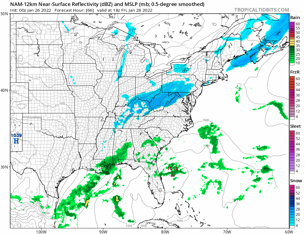
 Meanwhile a very deep trough in the upper air will strengthen and a strong upper air storm will form in Eastern Tennessee/ Western North Carolina, energizing the low as it moves northeast up the coast offshore. Snow will start to break out Friday night from Eastern Pennsylvania to Southern New England with heavier accumulating snow after midnight and into Saturday morning.
This loop starts at 1pm Friday and ends at 7am Saturay. Some of the snow shown initially Friday afternoon is on the light side and might be a bit overdone but you can see how the strengthening low begins to show a growing area of dark blue heavy snow and it runs down all the way into Eastern Georgia and the Carolinas! The NAM only goes out to Saturday morning 7am on its latest run so we will have to wait until later Wednesday to see what it does for Saturday during the day. The upper air suggests snow moves up the coast with a sharp cut off probably somewhere in Eastern Pennsylvania to the west and the Lower Hudson Valley to the north.
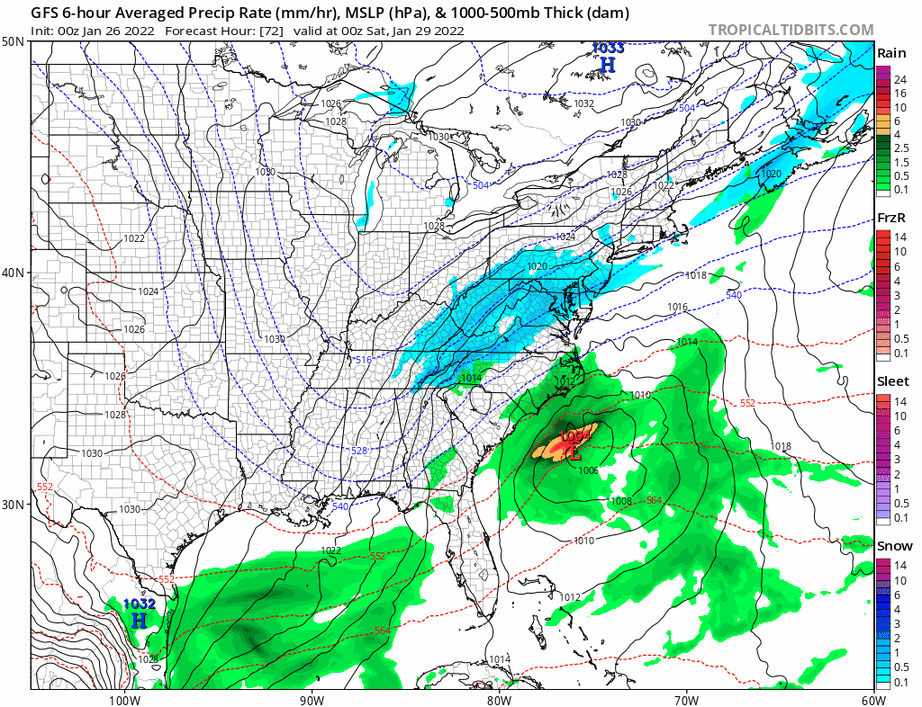
Now come the iissues and that is illustrated by the GFS model which doesn not sharpen the upper trough like the other and as a result it is much further east tonight and it is a significant shift from the prior 2 runs. It suggests no snow west of NYC and coastal New Jersey. There will be a very sharp cut off from no snow to heavy snow. Very little falls west of NYC and the Jersey shore while heavier snows will be over Eastern Long Island, Southeastern Connecticut, and Southeastern New England. The Canadian has backed off from the overdeveloped monster storm it had earlier today but it is west of the GFS and has snow extending west of the coast. It has heavier snows from coastal New Jersey to Central Long Island and Central Connecticut eastward with lighter snows to the west into Eastern Pennsylvania.
The bottom line is that we still have to watch the developing upper trough and whether it strengthens and sharpens enough to bring this storm up the coast and we still need to determine track. I was hoping from a forecasting standpoint that the models would line up even tighter than today but the GFS threw a curve ball to that plan. The European will have its say overnight. We will just have to sit back and wait for more on Wednesday.
Meanwhile a very deep trough in the upper air will strengthen and a strong upper air storm will form in Eastern Tennessee/ Western North Carolina, energizing the low as it moves northeast up the coast offshore. Snow will start to break out Friday night from Eastern Pennsylvania to Southern New England with heavier accumulating snow after midnight and into Saturday morning.
This loop starts at 1pm Friday and ends at 7am Saturay. Some of the snow shown initially Friday afternoon is on the light side and might be a bit overdone but you can see how the strengthening low begins to show a growing area of dark blue heavy snow and it runs down all the way into Eastern Georgia and the Carolinas! The NAM only goes out to Saturday morning 7am on its latest run so we will have to wait until later Wednesday to see what it does for Saturday during the day. The upper air suggests snow moves up the coast with a sharp cut off probably somewhere in Eastern Pennsylvania to the west and the Lower Hudson Valley to the north.
Now come the iissues and that is illustrated by the GFS model which doesn not sharpen the upper trough like the other and as a result it is much further east tonight and it is a significant shift from the prior 2 runs. It suggests no snow west of NYC and coastal New Jersey. There will be a very sharp cut off from no snow to heavy snow. Very little falls west of NYC and the Jersey shore while heavier snows will be over Eastern Long Island, Southeastern Connecticut, and Southeastern New England. The Canadian has backed off from the overdeveloped monster storm it had earlier today but it is west of the GFS and has snow extending west of the coast. It has heavier snows from coastal New Jersey to Central Long Island and Central Connecticut eastward with lighter snows to the west into Eastern Pennsylvania.
The bottom line is that we still have to watch the developing upper trough and whether it strengthens and sharpens enough to bring this storm up the coast and we still need to determine track. I was hoping from a forecasting standpoint that the models would line up even tighter than today but the GFS threw a curve ball to that plan. The European will have its say overnight. We will just have to sit back and wait for more on Wednesday.
BE SURE TO DOWNLOAD THE FREE METEOROLOGIST JOE CIOFFI WEATHER APP &
ANGRY BEN'S FREE WEATHER APP "THE ANGRY WEATHERMAN!

MANY THANKS TO TROPICAL TIDBITS & F5 WEATHER FOR THE USE OF MAPS
Please note that with regards to any severe weather, tropical storms, or hurricanes, should a storm be threatening, please consult your local National Weather Service office or your local government officials about what action you should be taking to protect life and property.