
DOWNLOAD MY NEW FREE JOESTRADAMUS WEATHER APP FOR ANDROID
THE APP IS ABSOLUTELY FREE TO ALL BUT CONSIDERING SUBSCRIBING TO PATREON FOR A WEATHER EXPERIENCE FREE OF ADS, EXCLUSIVE VIDEOS FOR MEMBERS ONLY AND MUCH MORE…STARTS AT $2 A MONTH..MESSAGE ME AT ANY TIME
SNOW FORECAST JOE’S FINAL CALL 1/19-20/2019
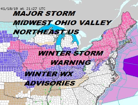
WINTER STORM WARNING FOR NORTHERN NEW JERSEY, HUDSON VALLEY WESTERN CT
Winter Storm Warnings cover a large portion of the Midwest and the Northeast tonight. Some of those warnings for snow that is about to begin or has already been falling in the Plains and Midwest. The rest for Saturday into Sunday. Our area sees Winter Storm Warnings for All Pennsylvania (except the Southeast counties east of Lancaster), most of Northern New Jersey, the Hudson Valley down to the NYC line and Western & Southwest Connecticut. Winter Storm Watches remain in effect for New Jersey counties closer to NYC and also for the immediate counties south of Route 78.
Now for the final call snow forecast. PLEASE BEAR IN MIND THIS IS MY FORECAST WHICH WILL LIKELY DIFFER FROM THE NATIONAL WEATHER SERVICE SNOW FORECASTS. Since I know most people forecast shop when it comes to snow, I just want to make it clear that I struggled with these numbers. In general I am lower than weather service forecast amounts. The situation is tenuous with low level cold air and the impact of sleet and freezing rain. Where is the 32 degree temperature line going to be early Sunday morning as warm air comes up from the south? That is the overhanging question with this storm. I don’t see this as a situation where much of the area needs to worry about this begin all snow. It will change to sleet and in coastal areas rain…it is a matter of when. An extra hour or two of snow or freezing temperatures becomes a bigger problem as time passes.
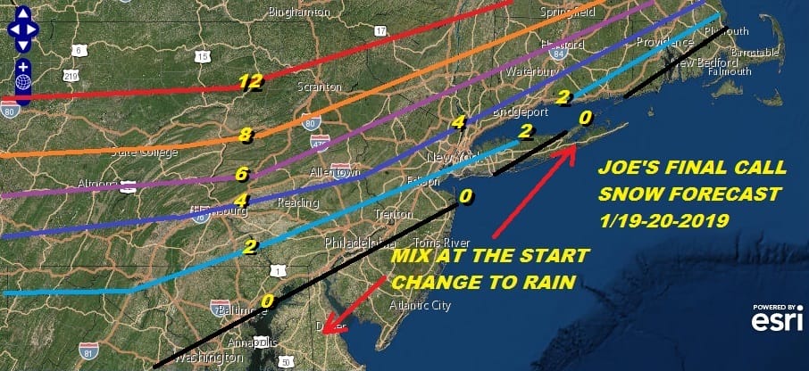
This is my final call. I pulled back the snow amounts slightly on the southern flank and left the northern flank virtually the same. The 12 inch plus line hasn’t changed much since the early call map a few days ago. It is the zone in the middle that right over us that is the tough part here. Snow will be fast and quick before going to sleet and then to rain. The black line is the southern edge of a coating. South and east of there it is mostly rain with some mix at the start. Snow arrives from west to east in the mid to late afternoon across Pennsylvania and then in New Jersey the Hudson Valley to NYC at 7pm and to Western Connecticut and Long Island shortly afterward. Then it is a change to rain from south to north.

The first frame of the loop is 1pm Saturday. The last frame is 1pm Sunday. Once this plays through it is on to bitter cold air for Sunday night and Monday with lows Monday in the range of -5 to +5 in most places and highs only in the high single digits to low teens Monday afternoon. At least we will have ineffective sunshine.
EASTERN SATELLITE

REGIONAL RADAR

As for tonight there are not issues. Skies should at least partially clear tonight with most lows in the 20s. Then Saturday it is arriving and thickening clouds with highs reaching into the 30s. I have played my hand here with my forecast. Let’s see how this ultimately plays out.
ADDITIONAL STORM COVERAGE IS AVAILABLE ON PATREON
MANY THANKS TO TROPICAL TIDBITS FOR THE USE OF MAPS
Please note that with regards to any tropical storms or hurricanes, should a storm be threatening, please consult your local National Weather Service office or your local government officials about what action you should be taking to protect life and property.


