
DOWNLOAD MY NEW FREE JOESTRADAMUS WEATHER APP FOR ANDROID
THE APP IS ABSOLUTELY FREE TO ALL BUT CONSIDERING SUBSCRIBING TO PATREON FOR A WEATHER EXPERIENCE FREE OF ADS, EXCLUSIVE VIDEOS FOR MEMBERS ONLY AND MUCH MORE…STARTS AT $2 A MONTH..MESSAGE ME AT ANY TIME
Snow Rain Bitter Cold Arctic Blast Single Digits Monday Morning
The storm that is has brought lots of snow across the country is headed into the northeast later today and tonight. There are no changes in my snow forecast final call from yesterday. The temperature profile this morning that I’m seeing is not all that promising for snow and it will change to sleet and then rain relatively quickly along the coast. and then eventually work its way inland. Clouds are rolling in this morning from the west and they will thicken up fairly quickly. It is not that cold this morning overall. Clouds kept temperatures up for most of the night and we are in the upper 20s to lower 30s already.
EASTERN SATELLITE

REGIONAL RADAR

Another indicator that this is not a scenario that is especially bullish for snow here is the fact that on the regional radar you can begin to see some snow appear across upstate NY. When it starts to snow there and in Vermont before it starts to snow here, that means the low is tracking to our west. We have a deepening wave that will head from Kentucky to Eastern Pennsylvania and then across Southern New England. That means a quick burst of snow and then to rain. With south winds coming into play, that should even keep icing issues down to a minimum.

The new HRRR model 12 hour radar sequence says it all. This is a burial for upstate NY to Central and Northern New England with 1 to 2 feet there. The low track is all wrong and is actually even further left than any model run of the last few days.
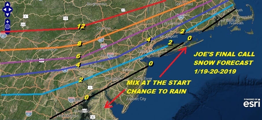
The final call map I think is okay..the southern end of 2 inches is possibly too far south but at this point Im just going to leave it be. Northwest NJ to the Middle Hudson Valley gets 8 inches plus before any change to sleet or rain. It all ends tomorrow morning. then it turns bitterly cold as temperatures fall into the 20s during the afternoon. By the time we get to Monday morning it will be down in the single digits to near zero.

Some areas inland Monday may have a tough time getting back to 10! This will be the coldest air of the season so far and compares relative to normal to the cold blast from Thanksgiving. Tuesday the cold air pulls out and the next cold front approaches. Believe it or not the warm up will be rapid with temperatures by Wednesday in the 40s and the chance for rain showers later in the day. Hard to imagine all that cold and then it warms up and just rains but that is the way it works some time. We haven’t really spent too much time looking at the long range with today’s system taking most of our attention.
MANY THANKS TO TROPICAL TIDBITS FOR THE USE OF MAPS
Please note that with regards to any tropical storms or hurricanes, should a storm be threatening, please consult your local National Weather Service office or your local government officials about what action you should be taking to protect life and property.


