
DOWNLOAD MY NEW FREE JOESTRADAMUS WEATHER APP FOR ANDROID
THE APP IS ABSOLUTELY FREE TO ALL BUT CONSIDERING SUBSCRIBING TO PATREON FOR A WEATHER EXPERIENCE FREE OF ADS, EXCLUSIVE VIDEOS FOR MEMBERS ONLY AND MUCH MORE…STARTS AT $2 A MONTH..MESSAGE ME AT ANY TIME
Winter Storm Warning Flood Watch Coastal Flooding Bitter Cold
We have all sorts of watches warnings and advisories to cover everything from snow to ice to rain, tides, and perhaps even some thunderstorm warnings Sunday morning before this is all said and done. The snow part of this equation continues to diminish as the low continues to track further and further west in spite of snow weenies on twitter talking about models trending one way or the other. When it starts to snow in Vermont before it starts snowing here, it is not a good sign for a snow storm here. It is an indicated that the low is tracking too far to the west. You can see that on the regional radar this evening as we area still waiting for precipitation to arrive. If it were going to be a significant snowstorm here you would have needed to see snow in Maryland and northern Virginia. This is not the case today.

We will gradually see precipitation fill in on the radars in the next few hours. A quick burst of snow and then rain near the coast. A longer period of snow in Northwest New Jersey to the Hudson Valley north of 287 and Connecticut north of Route 15. All areas from the coast to inland areas even north and west of Route 84 will be changing to rain overnight.
LOCAL RADAR NEW YORK CITY

LOCAL RADAR PHILADELPHIA


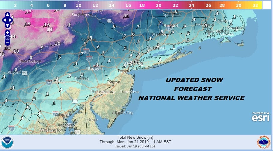
Lets break it all done with regards to snowfall. Snow amount continue to trend lower as advertised yesterday. The National Weather Service snow forecast map has sliced amounts down in half and they still might be too high.
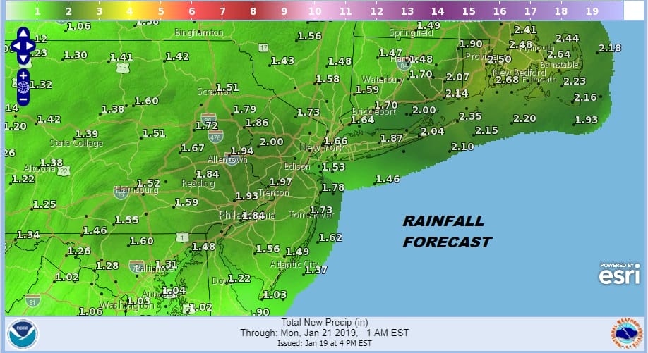
Rain now becomes front and center for most of the area and flooding is a concern with 2 inches or more of rain possible in some areas. The first Flood Watches are up for Long Island and parts of Northern & Central New Jersey and you can expect this area to be expanded.
Sunday morning look for thunderstorms and I would not at all be surprised if we wind up with a severe thunderstorm warning posted for someone some where. Rain will end from west to east. Areas inland would have changed to rain by morning north of Route 84 and also in Connecticut. This will all come to an end before midday. Then it will be dropping temperatures to the single digits by Monday Morning with gusty northerly winds and wind chills below zero.

Temperatures Monday with some sunshine will only be barely back into the teens and then back down into the single digits Tuesday morning. Temperatures will rebound midweek. Some showers of rain are in the forecast for Wednesday with temperatures back in the 40s.
MANY THANKS TO TROPICAL TIDBITS FOR THE USE OF MAPS
Please note that with regards to any tropical storms or hurricanes, should a storm be threatening, please consult your local National Weather Service office or your local government officials about what action you should be taking to protect life and property.


