
Long Range Blocking Appears Short Range More Volatility
Long Range Blocking Appears Short Range More Volatility
Fasten your seat belts because over the next few weeks we are in for a bit of a wild ride. The current pattern remains fast and volatile with cold shots coming in fast and going out fast. Warm ups in between are going to start going higher. The first such warm up arrives over the next 2 days. In the transition we are going to see clouds tonight. As temperatures rise and a little bit of a southeast wind could cause some spotty drizzle to develop overnight which might freeze inland. Temperatures will hover in the upper 20s and low 30s until about midnight and then begin creeping higher by daybreak. The clouds will move out and we will see sunshine develop on Wednesday. Temperatures should reach the 50s in most places.
US SATELLITE

REGIONAL RADAR

With milder air arriving we are seeing some spotty precipitation breaking out on the radar to our south but this area should pass to the east with no consequence to us overnight. Some of those radar echos are showing up on the Mount Holly radar below.
LOCAL RADAR NEW YORK CITY

LOCAL RADAR PHILADELPHIA


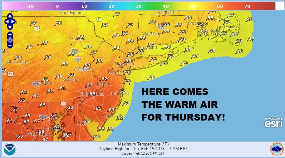
Wednesday night we transition over to an even warmer air mass and there could be some rain Wednesday night into early Thursday before we go to some sunshine Thursday afternoon. Temperatures Thursday are on cue to reach the 60s and some warm spots could reach 70 if there is enough sun.
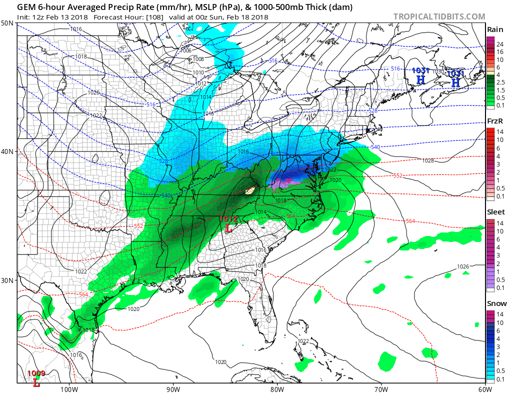
Then here comes a cold front with rain Thursday night into Friday morning. Colder air follows with temperatures eventually settling in the 40s Friday afternoon and then dropping to the 20s on Saturday morning. We have been saying that if one of these weather systems times out with the cold air there could be a snow issue and some models are showing this possibility for Saturday night into Sunday morning.
CANADIAN MODEL FORECAST SATURDAY INTO SUNDAY CLICK TO ANIMATE
How this plays out or if this plays out at all remains to be seen. Once this system is done, we will warm up again next week and the middle of next week could be quite warm with temperatures in the 60s or perhaps even 70 or better is possible depending on clouds and wind.
BLOCKING PATTERN DEVELOPS IN THE LONG RANGE
Weather models continue to signal a pattern change to begin in about 10 days which would correspond with the huge split that has occurred in the polar vortex in the stratosphere. Meteorologist have be debating what the outcome of such of split would be and the best advise is to just watch it happen and let it tell you rather than trying to outguess it. The blocking signatures appear on all the models in the long range and the GFS has been particularly aggressive with this idea.
GFS JET STREAM FORECAST MARCH 1ST

The change in the upper pattern is about as radical a change as you can see. The ridge off the Southeast coast of the US and the ridge in the Gulf of Alaska are gone. Instead we have an absolute bottle neck of systems from the Pacific to the Atlantic south of 50 degrees north. The Atlantic blocking is huge. In the Pacific the chess pieces seem to be getting rearranged to some degree. There are all sorts of implications and possibilities that could come of this in the long range on both extremes of the spectrum. This is going to be a rather fascinating time going into the first few weeks of March if we are dealing with an upper air as complex as this.
AS FAR AS SNOW FOR SATURDAY NIGHT AND SUNDAY HERE IS JOESTRADAMUS WITH THE LATEST ON THAT SYSTEM
 GET JOE A CIGAR IF YOU LIKE

FiOS1 News Weather Forecast For Long Island
FiOS1 News Weather Forecast For New Jersey
FiOS1 News Weather Forecast For Hudson Valley


