DOWNLOAD MY NEW FREE JOESTRADAMUS WEATHER APP FOR ANDROID
THE APP IS ABSOLUTELY FREE TO ALL BUT CONSIDERING SUBSCRIBING TO PATREON FOR A WEATHER EXPERIENCE FREE OF ADS, EXCLUSIVE VIDEOS FOR MEMBERS ONLY AND MUCH MORE…STARTS AT $2 A MONTH..MESSAGE ME AT ANY TIME
Light Snow Mix Rain Overnight Rain Raw Saturday
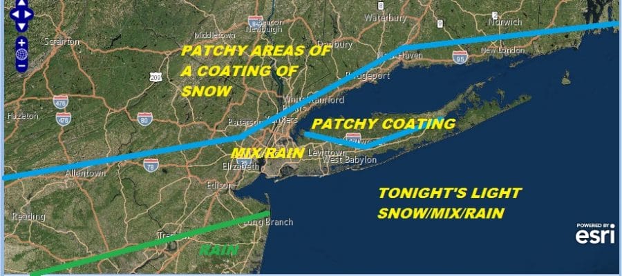
We are watching tonight’s weather systems which look benign in nature. Two separate systems that basically stay separate. The northern system is attempting to exert an influence by pulling the southern stream system further to the north. It just misses being a more serious issue. The northern stream eventually catches up to the south but that happens when it is well offshore. Clouds have been increasing from west to east as the satellite loop shows. The radars remain quiet for now as we are just beginning to see the first echos showing up on the regional radar well to the south. Temperatures have been holding in the 30s and we will settle to near or just above freezing tonight. This could make for some slick spots developing tonight, mainly north and west of the warmer urban centers that surround NYC..
EASTERN SATELLITE

REGIONAL RADAR

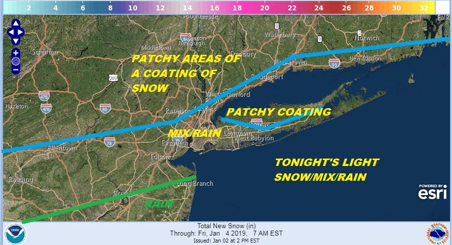
I’m pretty much leaving things alone from last night’s forecast. Patchy areas of a coating to at most an inch in some places. There could also be a pocket of colder air on Long Island in Northwest Nassau to East Central Suffolk County where there could be a patchy accumulation. Just be on the alert for slick spots if you are driving overnight. Timing would be from about 11pm until about daybreak. Central and particularly South Jersey could see a steady period of rain overnight with this southern feature getting close enough to put that area in a solid arear of light rain.
NEXT WEATHER SYSTEM SATURDAY
The stalled front to our south is creating 2 waves. One tonight and a second one for Saturday. This system has more support in the upper air and while Friday will be sunny at least into the afternoon, clouds will arrive and then a raw rainy Saturday is in store. While temperatures Friday could break 50, Saturday temperatures will settle in the upper 30s to middle 40s with a raw northeast wind.

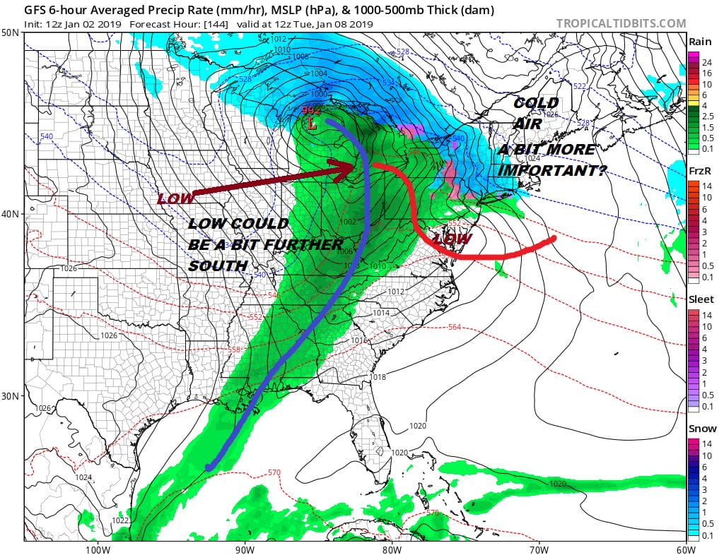
Once this low plays through the busy pattern continues next week. Sunday and Monday will be dry but the next weather system heads out of the Plains and heads toward the Great Lakes. I think there is a chance the low could a bit to the south than modeled and cold air a bit more important. I could alter the outcome here a bit and create a set up for a bit of a mess at the start of precipitation Monday night along the coast.
The longer range continues to progress albeit slowly and in a grinding fashion. Weather models seem to be slowly responding to the splitting of the polar vortex in the stratosphere. The long range here suggests the vortex will strengthen over North America. We are still waiting to see what the long range implications will be from all of this action in the stratosphere.
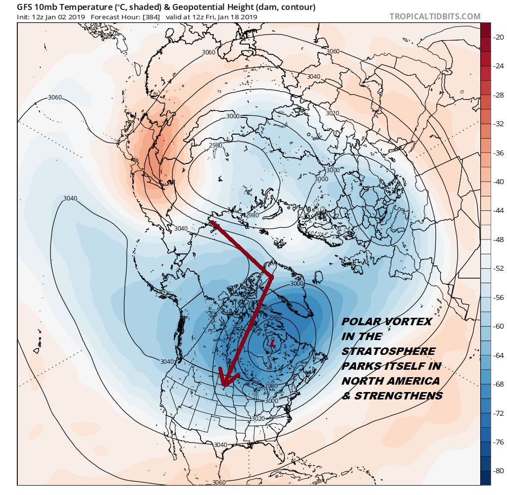
Dr Judah Cohen is the man who watches the stratosphere intently and he is very bullish on cold winter weather coming into the Eastern US. We will be having on a special live stream on my youtube channel one day next week to discuss the implications of this split for the medium and long range.
MANY THANKS TO TROPICAL TIDBITS FOR THE USE OF MAPS
Please note that with regards to any tropical storms or hurricanes, should a storm be threatening, please consult your local National Weather Service office or your local government officials about what action you should be taking to protect life and property.