DOWNLOAD MY NEW FREE JOESTRADAMUS WEATHER APP FOR ANDROID
THE APP IS ABSOLUTELY FREE TO ALL BUT CONSIDERING SUBSCRIBING TO PATREON FOR A WEATHER EXPERIENCE FREE OF ADS, EXCLUSIVE VIDEOS FOR MEMBERS ONLY AND MUCH MORE…STARTS AT $2 A MONTH..MESSAGE ME AT ANY TIME
Rain Saturday Dry Sunday Busy Pattern Continues
We managed to get through the night with hardly a drop of precipitation as the weather system that passed to our north and the weather system that passed to our south were both much weaker and flatter than forecast. The clues yesterday were a less than robust radar in the southern stream and a non existent one in the north. We can see the cloud line of cirrus running to the north of the coast and we would think this should shrink southward today with decreasing clouds and an increase in the amount of sunshine from south to north. Lately we have noticed that clouds have wound up being a bit more stubborn due to this persistent jet to the south so we don’t expect this to break out wide open with sunshine today. Temperatures will be in the 40s. Radars are quiet and there will be no issues there through Friday.
EASTERN SATELLITE

REGIONAL RADAR

We should clear out tonight with lows in the upper 20s to mid 30s. With no cold air around of any importance we will see sunshine for much of Friday before clouds arrive later in the day. Highs will reach the upper 40s and lower 50s. Then the frontal boundary to the south buckles with another stronger wave of low pressure moving across the Gulf States. This aims for the Mid Altantic coast and the result will be rain here arriving Friday night and lasting on and off through Saturday. It will be downright gloomy and raw with highs Saturday just into the 40s.

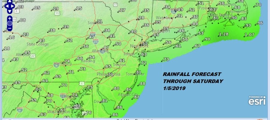
Rainfall from this weather system looks to be on the order of three quarters of an inch to an inch or so and it doesn’t seem to be too problematic. It all moves away and weather conditions improve Sunday with some sunshine returning. It will turn a bit colder Sunday into Monday but this looks to be a glancing push of cold air before the next weather system approaches for Monday night and Tuesday. This is a warm front cold front scenario with some showers Monday night into Tuesday. There could be a little snow or sleet at the start Monday evening for a cheap thrill especially inland. After this system goes by we will be waiting to see how weather models evolve and handle the very large scale changes that are going on the upper atmosphere and the stratosphere. Weather models seem to be grasping at how all of these large scale changes play out and having a difficult time coming to grips with it all. We like to spend our mornings absorbing the overnight models and waiting to see what the afternoon series takes us. We will tear this all apart later today. We all know about the polar vortex and the polar vortex split which is a done deal. Now it is a matter of seeing if this is ultimate pattern driver or is the action in the Pacific so overpowering that it trumps everything else.
MANY THANKS TO TROPICAL TIDBITS FOR THE USE OF MAPS
Please note that with regards to any tropical storms or hurricanes, should a storm be threatening, please consult your local National Weather Service office or your local government officials about what action you should be taking to protect life and property.


