DOWNLOAD MY NEW FREE JOESTRADAMUS WEATHER APP FOR ANDROID
THE APP IS ABSOLUTELY FREE TO ALL BUT CONSIDERING SUBSCRIBING TO PATREON FOR A WEATHER EXPERIENCE FREE OF ADS, EXCLUSIVE VIDEOS FOR MEMBERS ONLY AND MUCH MORE…STARTS AT $2 A MONTH..MESSAGE ME AT ANY TIME
Colder Reality Snow Mix Rain Overnight Rain Friday Night Saturday
After highs reaching into the 60s in some areas yesterday there was a reality check this morning as temperatures bottomed in the upper 20s and lower 30s. It did not clear out much last night thanks to high clouds streaming eastward. This is part of the old stalled cold front from the New Years rain storm. This is likely to limit sunshine today and also limit the daily rise in temperatures. Highs will probably hover in the 30s to near 40 degrees. Clouds will thicken up a bit in the afternoon and evening. Radars are quiet this morning and should remain dry into this evening.
EASTERN SATELLITE

REGIONAL RADAR

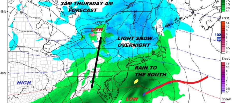
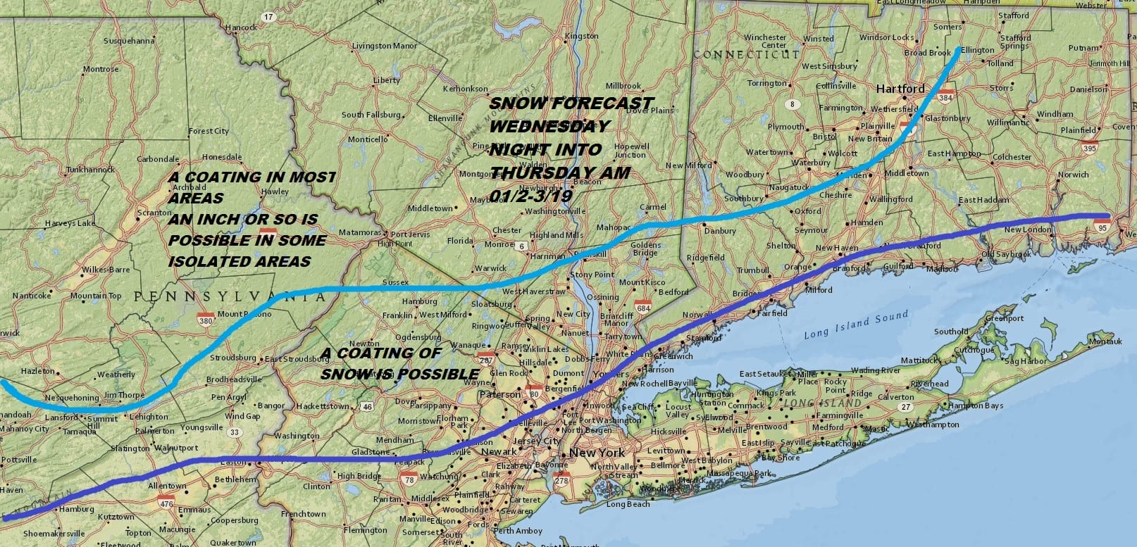
Tonight we have a wave of low pressure developing to the south that will pass offshore and we also have energy to the north. Sometimes the two systems get together and sometimes they don’t. When they do it could be problematic snow wise but it seems the two systems will stay separate enough to prevent serious issues. We will see a little snow, sleet and even some pockets of freezing rain tonight inland with a mix or rain along the coast. This doesn’t amount to much and there is the outside chance that someone winds up with a coating of snow..perhaps a bit more well inland.
There could be some leftover precipitation tomorrow morning around daybreak but it should quickly disappear. Leftover clouds Thursday should give way to some breaks of sunshine. With no cold air behind this system highs will be in the 40s. Friday looks good with sunshine giving way to arriving clouds with highs in the 40s. Another low approaches Friday night into Saturday with some rain and a raw northeast wind. Saturday’s highs will be in the 40s.
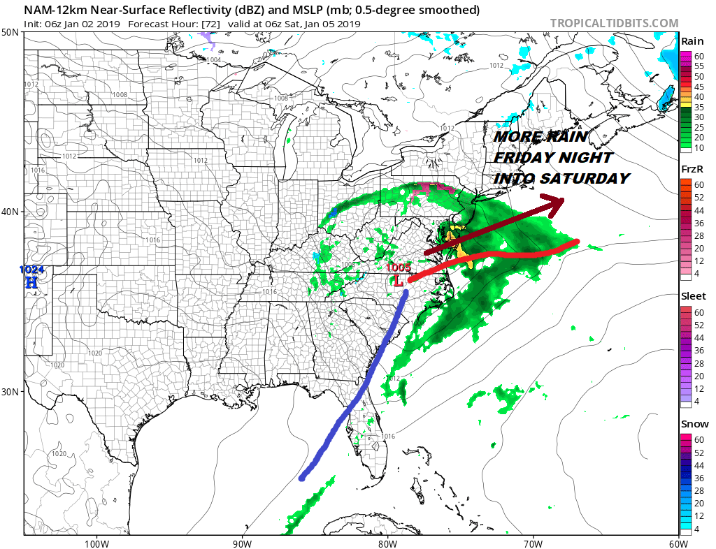
Right now this is not looking like a big rain producer north and west of NYC where rainfall could be an half inch or less but south of NYC to South Jersey, amounts will increase to 1 to 2 inches south of Route 195. We will look closer at this system later today.
LONG RANGE COLDER PATTERN DEVELOPS MID-MONTH
We continue to see evidence of a long term pattern change. Actually the colder overall pattern begins to appear as early as late next week. We see evidence of this being a sustained colder pattern for the longer term. Weather models overnight seem to be on course with this, This will likely bring some chances for snow going forward. The hows wheres whens and how much ARE NOT questions for the long range but are short range issues IF & WHEN chances start to pop up. All of this is being driven by a major change in the upper pattern in the stratosphere where planes fly. We will continue to monitor changes in weather models later today and will offer opinions on where this all takes us.
MANY THANKS TO TROPICAL TIDBITS FOR THE USE OF MAPS
Please note that with regards to any tropical storms or hurricanes, should a storm be threatening, please consult your local National Weather Service office or your local government officials about what action you should be taking to protect life and property.


