DOWNLOAD MY NEW FREE JOESTRADAMUS WEATHER APP FOR ALL DEVICES
THE APP IS ABSOLUTELY FREE TO ALL BUT CONSIDERING SUBSCRIBING TO PATREON FOR A WEATHER EXPERIENCE FREE OF ADS, EXCLUSIVE VIDEOS FOR MEMBERS ONLY AND MUCH MORE…STARTS AT $2 A MONTH..MESSAGE ME AT ANY TIME
Changeover Arrives Evening Rain Overnight Improvement Thursday
You can see the damage that has occurred to the radar echos this afternoon all thanks to the high in a “bad spot” Dry air at mid levels is ripping the bands of heavier snow apart. If you had gotten under one of those bands (mostly in Central & South Jersey) several inches accumulated. If you didn’t then it was a coating to an inch or so. This was what it was folks and the underperformance was no surprise give the less than ideal set up going into this. Now we head into this evening and we could see the radars rev up into this evening just as the warm air arrives and changes it all over to sleet and then to rain tonight. The rain pulls out during the early morning hours and then it is done.
REGIONAL RADAR

The unimpressive nature of the radar continues at the moment with streaks of heavy snow pushing out to the east. Large gaps thanks to dry air are evident all over the place.
LOCAL RADAR NEW YORK CITY

LOCAL RADAR PHILADELPHIA


Thursday we will see clouds giving way to sunshine with highs reaching the 50s. Friday looks like a good day with sunshine and highs in the 40s to near 50. Saturday we will see sunshine giving way to arriving clouds and colder as highs will be just into the 40s. The next storm system is going to be a powerhouse as it heads to the Great Lakes.
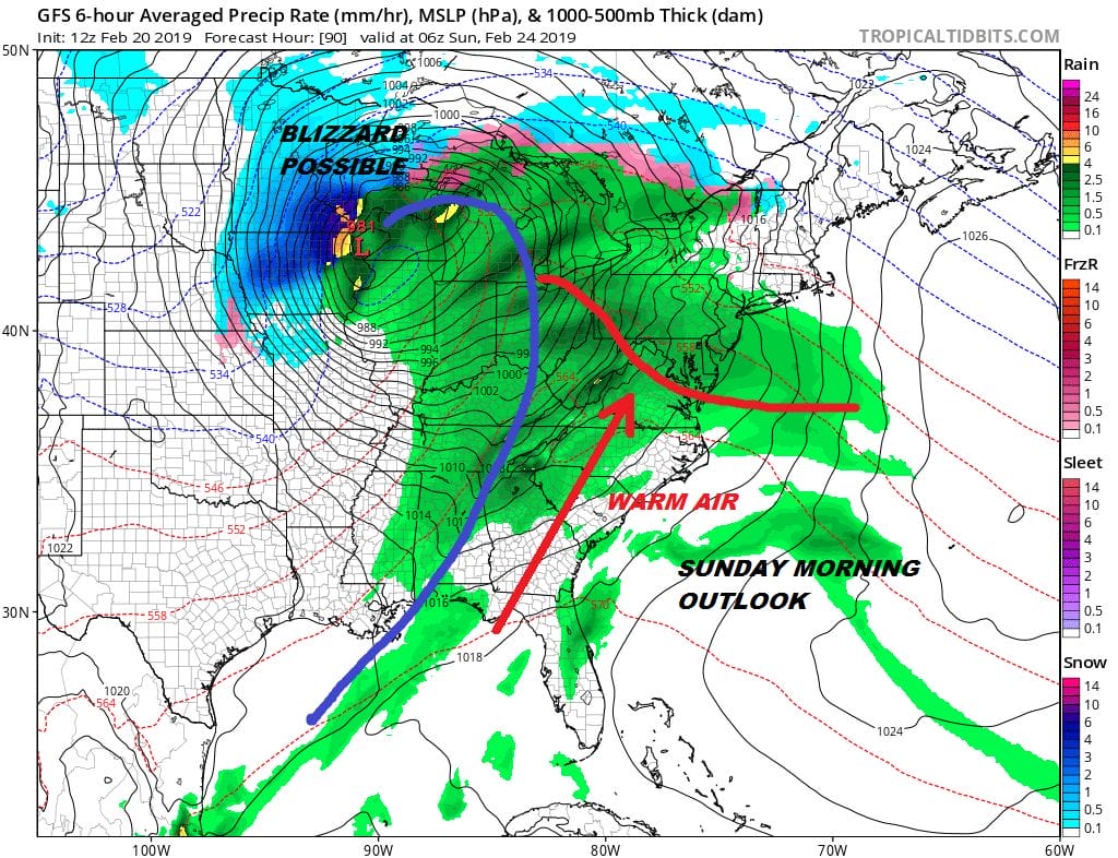
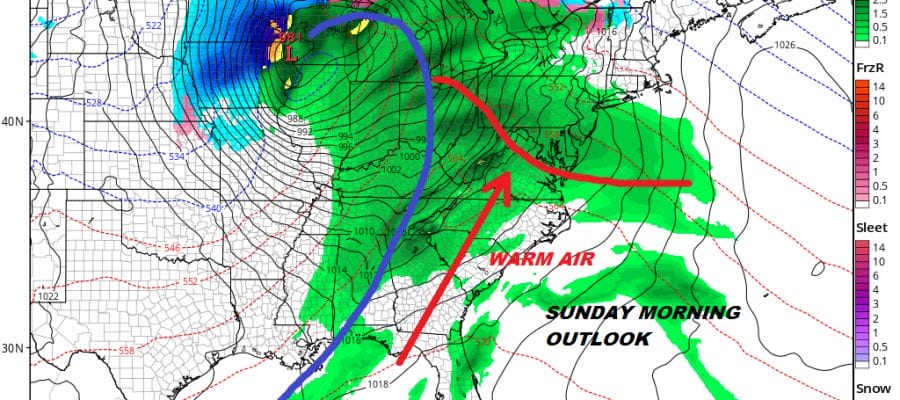
A major storm is going to develop over the weekend over the Western Great Lakes and this will produce blizzard conditions across parts of the upper Midwest. For us a warm front comes up with rain Saturday night into Sunday morning. Showers and temperatures into the 60s will be the story for Sunday until the cold front passes. Then it turns colder and drier for Monday. This storm will drive a brief pattern relaxation ( I hesitate to use the word change). The trough will disappear in the west and the trough will return to somewhere in the East. This will open up one short window of opportunity for something to happen during the first few days of March. I do expect this relaxation to be short lived and the action will shift back to the west after a week or two. Spring looks to come on time this year.
MANY THANKS TO TROPICAL TIDBITS FOR THE USE OF MAPS
Please note that with regards to any tropical storms or hurricanes, should a storm be threatening, please consult your local National Weather Service office or your local government officials about what action you should be taking to protect life and property.


