Autumn Arrives With A Nice Saturday of Sunshine
Onshore Winds Clouds and Some Rain South Sunday
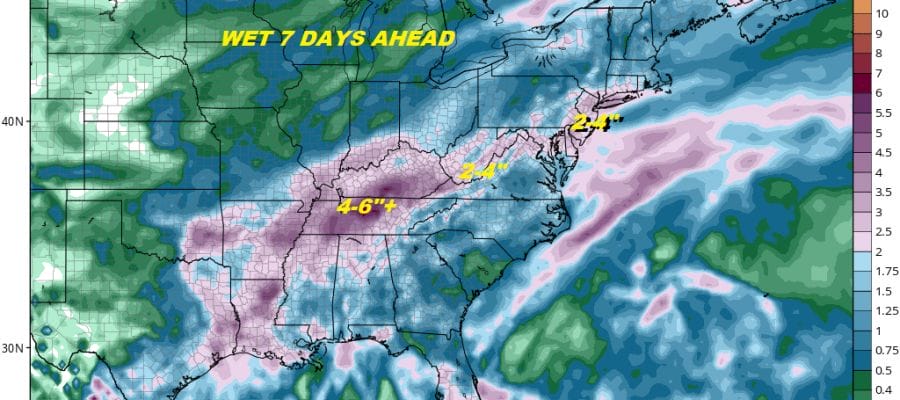
Rain Arrives Tuesday In A Wet Looking Week Ahead
We are waking up this morning to a cold front that has passed through overnight. Thunderstorms completely fell apart as advertised and now we look to a very nice day of no worse than partly sunny skies and temperatures in the low to mid 70s. There will be a freshening northeast wind thanks to high pressure building across New England & Southeastern Canada. This will be the better of the two weekend days as the cold front will be stalling out o the south of us this afternoon across the Middle Atlantic states.
EASTERN SATELLITE

REGIONAL RADAR

Clouds will be coming back in tonight but this will be another instance where areas to the north of NYC and the coast will be on the edge of the cloud cover while areas to the south in Southern New Jersey and Southeastern Pennsylvania not only will deal with clouds, but perhaps a bit of rain. A weak wave will be moving along the frontal boundary late Saturday night and Sunday morning. The rain won’t amount to much as the wave goes by. Dry air to the north will press southward as the day wears on and we could see some breaks of sunshine in the afternoon Sunday from NYC, Northern New Jersey, the Hudson Valley & Long Island. Temperatures on Sunday will just be in the low to mid 60s especially where there is cloud cover.
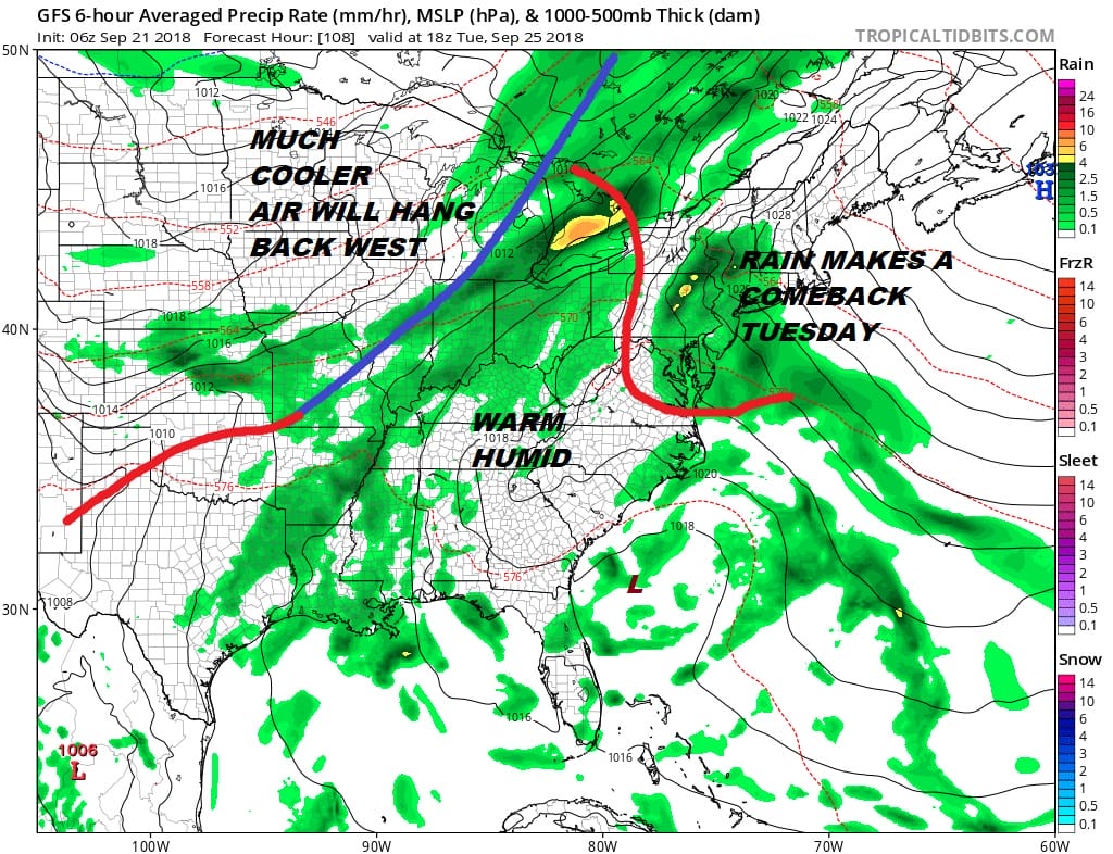
Monday begins the process of the front to the south coming back northward as a warm front. Some tropical moisture will likely get involved here. Clouds increase on Monday with highs in the 60s. Then we will see rain arrive during the early morning hours on Tuesday and then continue for most of the day. Highs again in the 60s. The rest of the week we will be struggling with slowing and stalling cold fronts and the chance for showers and thunderstorms Wednesday and Thursday. We may see genuine improvement in our weather until Friday or next weekend. Rainfall amounts for the next 7 days is fairly robust on all the models.

As far as the tropics are concerned we are watching 4 systems out in the Atlantic led by Tropical Depression 11 east of the Windward Islands. This system is forecast to dissipate in the next day or two thanks to strong upper air winds. The system that is off the southeast coast of the US is the closest to us and shows no signs of development. We will examine all four systems this morning on our video broadcast exclusive for Patreon members.
SUBSCRIBE TO PATREON FOR A WEATHER EXPERIENCE FREE OF ADS, EXCLUSIVE VIDEOS FOR MEMBERS ONLY AND MUCH MORE…STARTS AT $2 A MONTH..MESSAGE ME AT ANY TIME

MANY THANKS TO TROPICAL TIDBITS FOR THE USE OF MAPS
Please note that with regards to any tropical storms or hurricanes, should a storm be threatening, please consult your local National Weather Service office or your local government officials about what action you should be taking to protect life and property.
LATEST JOESTRADAMUS ON THE LONG RANGE

