TROPICAL STORM DEVELOPMENT POSSIBLE THIS WEEKEND
4 SUSPECT AREAS, 2 SHOW POSSIBILITIES
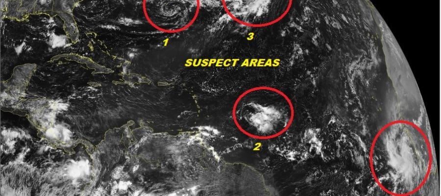
Watching the Atlantic Basin satellite loop we can pick out 4 areas that bear some watching but really there are only 2 of them that seem like they have a fair chance of developing over the next several days. The system that is over the Central Atlantic probably has the best chance of development since all the weather models are keying on this. The system that is off the African Coast ranks right behind it as having a chance to develop while the other 2 show little chance of becoming a tropical depression or a tropical storm.
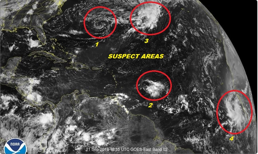
Suspect area number 1 is the one that is closest to the East Coast of the US and this is part of the frontal boundary that took the remnants of Florence out to the east. A low level circulation is evident there but it is completely void of any thunderstorm activity around the center. Upper level conditions are not supportive for this to develop and in fact models weaken this as it moves southwest and then westward toward the SE Coast of the US. Other than some clouds and scattered showers this should not be problematic unless we get some sort of major surprise.

Suspect area number 3 is in the Central Atlantic to the northeast of suspect area 1. This is forecast by all the models to develop into a subtropical or tropical storm in the next several days. It is trapped between two upper ridges so the path of least resistance seems to be for this to drift southward. It is so far out in the Atlantic that even if it does develop it poses no threat to any land areas.
WIDE ATLANTIC TROPICAL SATELLITE

Suspect area number 2 is disturbed weather with a tropical wave east of the Windward Islands. This system has been drifting around for days and upper level wind conditions are hostile here and this system is not forecast to develop.
Suspect area number 4 is off the African Coast and it is a strong well developed tropical wave. Conditions here are conducive for development in the next 5 days but we are getting to the time of year where the easterly steering winds are getting weaker in the Major Development region so if it does develop it will take its time moving across the Atlantic. It is fairly safe to say that there are no immediate threats to the US for the next week or so.
SUBSCRIBE TO PATREON FOR A WEATHER EXPERIENCE FREE OF ADS, EXCLUSIVE VIDEOS FOR MEMBERS ONLY AND MUCH MORE…STARTS AT $2 A MONTH..MESSAGE ME AT ANY TIME

THANKS TO TROPICAL TIDBITS FOR THE USE OF MAPS
Please consult your local National Weather Service office at weather.gov for the latest information on any tropical or storms or hurricanes that could be a threat to your area. Consult your local government officials regarding action you may need to take to secure life and property
FiOS1 News Weather Forecast For Long Island
FiOS1 News Weather Forecast For New Jersey
FiOS1 News Weather Forecast For Hudson Valley