TROPICAL DEPRESSION 11 EAST OF THE WINDWARDS FORECAST TO DISSIPATE
NEW TROPICAL DEPRESSION COULD BE FORMING OFF AFRICAN COAST
DEVELOPING STORM CENTRAL ATLANTIC LIKELY TO BECOME A TROPICAL STORM
WEAK CIRCULATION OFF EAST COAST REMAINS UNIMPRESSIVE
...TROPICAL DEPRESSION NOT MOVING VERY MUCH…
…EXPECTED TO DISSIPATE IN A DAY OR TWO…
SUMMARY OF 500 AM AST…0900 UTC…INFORMATION
———————————————-
LOCATION…13.0N 53.5W
ABOUT 505 MI…810 KM E OF THE WINDWARD ISLANDS
MAXIMUM SUSTAINED WINDS…35 MPH…55 KM/H
PRESENT MOVEMENT…W OR 270 DEGREES AT 5 MPH…7 KM/H
MINIMUM CENTRAL PRESSURE…1007 MB…29.74 INCHES
There are 4 systems in play at the moment though advisories are only being issued on one of them as of 9am Saturday. Tropical Depression 11 formed yesterday east of the Windward Islands in an environment of strong upper air winds which are forecast to get even stronger in the next day or two. It is 500 miles east of the Windward Islands and barely moving to the west at 5 mph. It poses no threat to land and should dissipate in a day or two. The satellite loop below shows strong winds aloft blowing the tops of the thunderstorms away to the northeast. This hostile environment should prevent this system from becoming an issue for the Windward or Leeward Islands.
WIDE ATLANTIC TROPICAL SATELLITE

Well out to the east in the Tropical Atlantic and just off the African coast we have what appears to be a developing tropical depression. The National Hurricane Center acknowledges this and advisories could be issued later today. The system is south of 10 degrees north and well south of the the Southern-most Cabo Verde Islands.
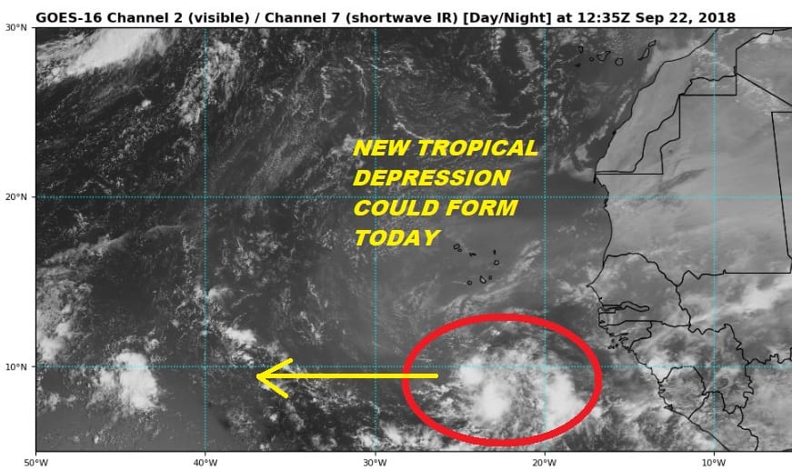
Assuming this system develops it is likely to move to the west until further notice but it might take a week for this system to move across the Atlantic so it will be no threat to land for awhile. Intensity guidance does strengthen this system into a tropical storm assuming the developing trend continues.
Back to the satellite loop is the large system in the Central Atlantic that is going to be dropping southward and is likely to become a subtropical or tropical storm. This is likely to meander for a week or more out in the Central Atlantic so it poses no threat to land.

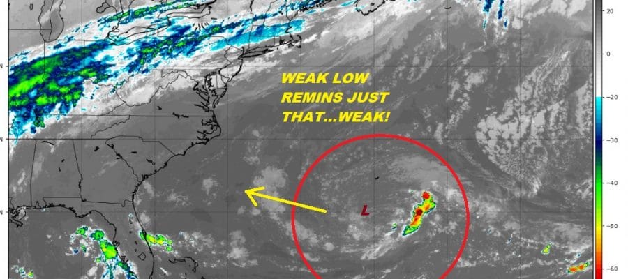
Now we come to system number 4 which is being touted by some as Florence coming back which is what this isn’t. Let’s doing something here that is different from the click bait artists and take a look at what this really is. Yes we do have a low level circulation sitting off the Southeast Coast of the US and it is drifting to the west northwest. It is also weak with very little if any convection with it except for some thunderstorms well to the east of the Center.
As this system draws closer to the coast there is a chance that it could become better organized and in fact a number of intensity models do show this strengthening however there are a number of things working against it. First and foremost is the complete lack of any thunderstorms near the center. The upper air wind environment at the moment is hostile. We could see that improve somewhat Monday and Tuesday as that low level swirl nears the coast. This could create some showery rains for the Coastal Carolinas Monday night or Tuesday but at the moment we are not talking about anything that could substantially add to the Florence woes. The approaching frontal boundary to the west across the Appalachians Tuesday could wind up absorbing this making it a non event for the most part. If we start to see some thunderstorms develop near the center and the low tightening up a bit then that would be a different story. However not one model that I have looked at suggests that is going to happen and the upper air argues against this.
SUBSCRIBE TO PATREON FOR A WEATHER EXPERIENCE FREE OF ADS, EXCLUSIVE VIDEOS FOR MEMBERS ONLY AND MUCH MORE…STARTS AT $2 A MONTH..MESSAGE ME AT ANY TIME

THANKS TO TROPICAL TIDBITS FOR THE USE OF MAPS
Please consult your local National Weather Service office at weather.gov for the latest information on any tropical or storms or hurricanes that could be a threat to your area. Consult your local government officials regarding action you may need to take to secure life and property
FiOS1 News Weather Forecast For Long Island
FiOS1 News Weather Forecast For New Jersey
FiOS1 News Weather Forecast For Hudson Valley