Winter Weather Advisory NW New Jersey Ne Pennsylvania
Winter Weather Advisory NW New Jersey Ne Pennsylvania Flood Watch Hudson Valley Connecticut
In a bit of getting ahead of the curve, a Winter Weather Advisory has been posted for Northeastern Pennsylvania south to near Route 78 & Northwest New Jersey. Freezing rain will be the main issue here early Saturday morning as temperatures fall rapidly below freezing. For the Hudson Valley & Connecticut Flood Watch is posted for heavy rains and the potential for some flooding. A change to freezing rain is possible north of Route 84 Saturday morning as well. Bear all this in mind if you have travel plans for Friday and Saturday as we are headed into a holiday weekend.
This evening we are sitting in clouds and temperatures which have risen to the mid 40s to mid 50s will probably hold steady or only fall slightly overnight. Fog is likely to develop and it will be dense in some areas. Rain will start moving into Eastern Pennsylvania and Western New Jersey before daybreak and shortly afterwards to the east. Rains will be heavy and showery in nature with more numerous showers late Friday and Friday night. Temperatures will be rising to near or even over 60 in some places. Bear in mind the ground is frozen and combine that with melting snow cover and heavy rain and you have the potential for flooding.
REGIONAL RADAR

Rain is showing up on the regional radar but much of it well to the west and moving north northeast. We will have to wait for the frontal boundary to shift eastward overnight to bring showers closer to the coast.

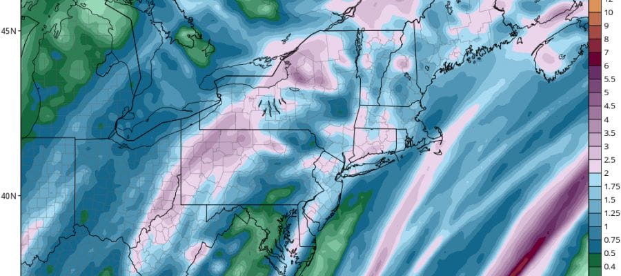
Rainfall amounts will be in the 2 inch plus range in many areas as the NAM model forecast shows and we think this will line up fairly well. Don’t be too surprised if you hear a thunderstorm rolling by during Friday and Friday night. Saturday we see the system pulling out with rain ending Saturday morning. Then temperatures drop through the 30s and into the 20s. By Sunday morning we will be in the single digits to low teens. Sunday looks like a decent day with some sunshine but highs will be just into the 20s. Next week looks cold and there is the chance for some snow late Tuesday into Wednesday though there is much uncertainty about how this system plays out.
 GET JOE A CIGAR IF YOU LIKE

FiOS1 News Weather Forecast For Long Island
FiOS1 News Weather Forecast For New Jersey
FiOS1 News Weather Forecast For Hudson Valley


