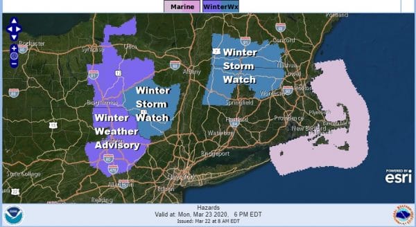
Winter Storm Watch Catskills Winter Weather Advisory NE Pennsylvania
A quiet Sunday of weather is underway but we do have a Winter Storm Watch posted for the Catskills as well as for the Berkshires in Massachusetts and that extends northward into Southern Vermont and New Hampshire. We will likely see additional Winter Weather Advisories go up later today for other areas in Upstate NY and interior New England.
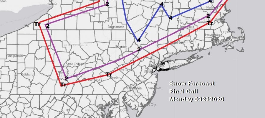
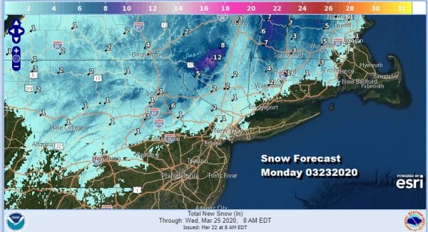
Not much has changed regarding the overall outcome of this and the forecasts for snow amounts remain basically unchanged. A few areas have been beefed up a bit, other taken back down a bit but in the end this weather system should play through as advertised over the last few days. The National Weather Service snow forecast numbers are above and my final call map is below.
Along the coast there certainly could be a few wet snow flakes or some ice pellets at the start if the precipitation comes in fast enough. Otherwise this looks to play out the way a typical early spring snowfall plays out. Accumulations will be inland and elevation driven. Sun angle will likely keep roads wet rather than white at least during the day.
SATELLITE
REGIONAL RADAR
Meanwhile we have today which is shaping up to be a nice quiet Sunday with sunshine for most of the day. Other than some stray clouds the satellite is relatively clear and the radars are quiet. Highs today will reach the low and middle 40s.
Clouds thicken up overnight and it looks like precipitation will come in faster and move out faster for Monday. Look for it to arrive in Southern Pennsylvania and Southern New Jersey around 4 or 5am, around NYC about 7am and in Southern New England and the Hudson Valley shortly afterward. You can see how the NAM which has been among the colder models has backed off a bit and the issue is the cold high that moves out to the east rather quickly. There is nothing to hold the cold air in.
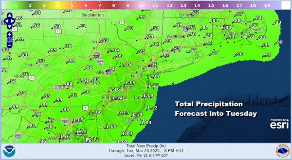
Total precipitation amounts remain the same on the order of 3/4 of an inch to an inch and a quarter. It all comes to and end late afternoon and evening Monday. Highs will be just in a range from mid 30s north of NYC to mid 40s south of PHL. Tuesday should bring some sun though clouds will return. Another weather system arrives with raw cold rainy conditions for most areas on Wednesday.
BE SURE TO DOWNLOAD THE FREE METEOROLOGIST JOE CIOFFI WEATHER APP &
ANGRY BEN’S FREE WEATHER APP “THE ANGRY WEATHERMAN!
MANY THANKS TO TROPICAL TIDBITS FOR THE USE OF MAPS
Please note that with regards to any severe weather, tropical storms, or hurricanes, should a storm be threatening, please consult your local National Weather Service office or your local government officials about what action you should be taking to protect life and property.

