Winter Storm Warnings Advisories NY New England
SHOP THE JOESTRADAMUS STORE
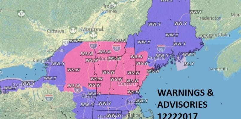
Winter Storm Warnings Advisories NY New England

With the Christmas Holiday weekend upon us many of you may be travelling or waiting for family to arrive. Today is a huge travel day and weather conditions across upstate NY & New England are not good. Numerous Winter Storm Warnings are posted along and north of Interstate 90 along with Winter Weather Advisories to the south. Much of the precipitation on the southern end of this area has been a bit overstated but look for weather conditions to deteriorate as you move northward especially north of Interstate 90. Snow as well as freezing rain and ice is going to be an issue in the areas in the Winter Storm Warnings making travel difficult.
SATELLITE LOOP

REGIONAL RADAR

Regional radar shows a large area of snow moving across Northeastern NY and Northwestern New England. Around our area the radars are rather patchy in nature and the precipitation has been either on the light side or more aloft than anything else. Be cautious of some slick spots north of Route 84 but I don’t believe it is going to be overly problematic. Temperatures will be on the slow rise for the rest of today and overnight. By morning everyone inland should be above freezing and approaching 40 while for areas along the coast and particularly Central and South Jersey we will see temperatures rising into the 50s.
LOCAL RADAR NEW YORK CITY

LOCAL RADAR PHILADELPHIA


Saturday we will see showers and a few heavier downpours before all the rain moves out tomorrow evening. Highs will range from the 40s in the Hudson Valley to the 60s in South Jersey and Southeastern Pennsylvania.
CHRISTMAS EVE & CHRISTMAS DAY OUTLOOK
There are no changes in my outlook for Christmas Eve & Christmas Day. It looks like Northern New Jersey north and west of route 78 and particularly north and northwest of route 80 should see enough snow to produce a white Christmas but not enough to cause any serious travel issues since all of this falls Sunday night into Christmas morning between midnight and 7am. For areas along the coast around NYC and Long Island it is a bit tricky as it will depend on where the low develops so this area will be on the edge. New Jersey south of Route 78 won’t see much snow at this point unless the low really revs up quick which is always a possibility.

For areas from the Hudson Valley across Connecticut here I think stands the best chance of seeing a 2 to 3 inch snowfall and amounts will increase as we go east into Connecticut where several inches or more could occur. I continue to leave my forecast amounts as is and may adjust them a bit tonight or on Saturday as we get closer. Next week the pattern looks especially wintry and potentially dynamic as weather models all are showing some sort of storm coming out of the Gulf States and heading up the East Coast with lots of cold air around. As always at this point tons of uncertainty.
 GET JOE A CIGAR IF YOU LIKE

FiOS1 News Weather Forecast For Long Island
FiOS1 News Weather Forecast For New Jersey
FiOS1 News Weather Forecast For Hudson Valley


