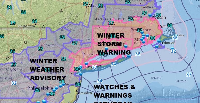
Winter Storm Warning NE New Jersey Hudson Valley Parts of NYC & Long Island
Winter Storm Warning NE New Jersey Hudson Valley
Parts of NYC & Long Island

Winter Storm Warning is in effect for Northeast New Jersey, the Hudson Valley along and south of Route 84, All of Connecticut, Parts of NYC north of 495, and Long Island north of the Long Island Expressway. Winter Storm Watch south of the L.I.E. In New Jersey the northeastern counties east of 287 are under a warning while Winter Weather Advisories are up west of 287 into Northeastern Pennsylvania and south in New Jersey to 195. Advisories in Pennsylvania extend into all of Eastern Pennsylvania as well as South Central Pennsylvania and North Central Maryland.
JOE’S SNOW FORECAST FOR LATE TODAY AND TONIGHT
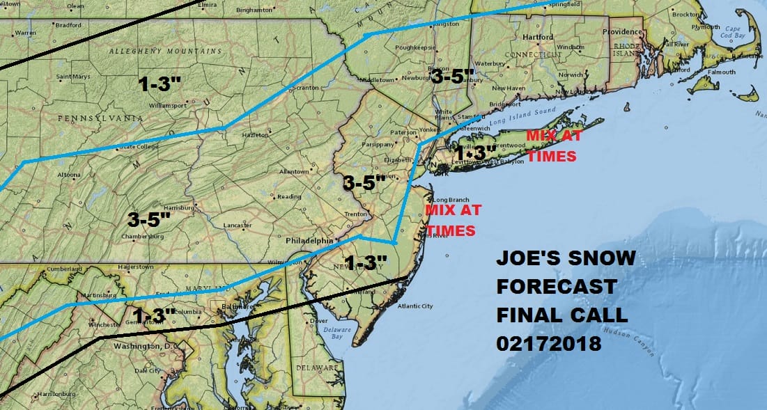
I have left my forecast absolutely unchanged from yesterday. I’m covering for a 1 to 3 inch snowfall for coastal areas and 3 to 5 inches inland. Weather models overnight and this morning were ever so slightly warmer. Models are all over the place and it is my opinion that the best course is to leave this alone. My numbers differ greatly in some areas from the National Weather Service. The bottom line is that even if we finish higher than this it won’t be as if someone winds up with a foot. All of this melts tomorrow as temperatures rise through the 40s. By Tuesday and Wednesday we will be in the 60s everywhere.

GET JOE A CIGAR SO HE CAN RELAX!
NEW YORK CITY AND VICINITY SNOW

NEW YORK CITY & VICINITY ICE

NEW JERSEY SE PA & VICINITY ICE
NEW JERSEY & PARTS OF NE PA

SOUTHERN AND SOUTHEAST NEW ENGLAND

NORTHERN NEW ENGLAND

WESTERN NEW ENGLAND

MIDDLE AND UPPER HUDSON VALLEY

CENTRAL NEW YORK & NE PA

WESTERN NEW YORK

CENTRAL & SOUTH CENTRAL PA

VIRGINIA & MARYLAND

DAILY NORTHEAST SNOWFALL

Please be advised that these are National Weather Service Forecast Maps and they auto update. Each office may update at different times and some offices are slower to update then others. Maps are usually updated before 5am and & 5pm however they may be updated at other times depending on forecast conditions. These are not my forecasts. My forecasts can be found on the JOE’S SNOWFORECAST PAGE. Individual forecasts for specific areas may also be found when conditions warrant on the my area forecasts. Those can be found on the website menu. Click on forecasts and then select your specific area.


