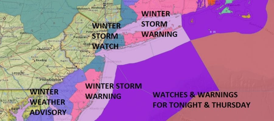
Winter Storm Warning Long Island Coastal New Jersey Connecticut
Winter Storm Warning Long Island
Coastal New Jersey Connecticut
WINTER STORM WATCH NEW YORK CITY SOUTHWEST CONNECTICUT
SOUTHERN WESTCHESTER
Overnight weather models continue this slow methodical westward shift in what will be a very powerful cyclone moving up the East Coast. The the track is close enough on all models to warrant a Winter Storm Warning to be issued for the areas in the map above and a Winter Storm Watch is now posted back to New York City, Southern Westchester County and Southwest Connecticut. I have also beefed up snow amounts given that the westward shift continues and I am being conservative here just to be cautious.
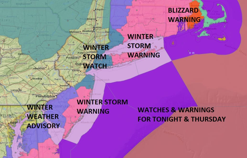
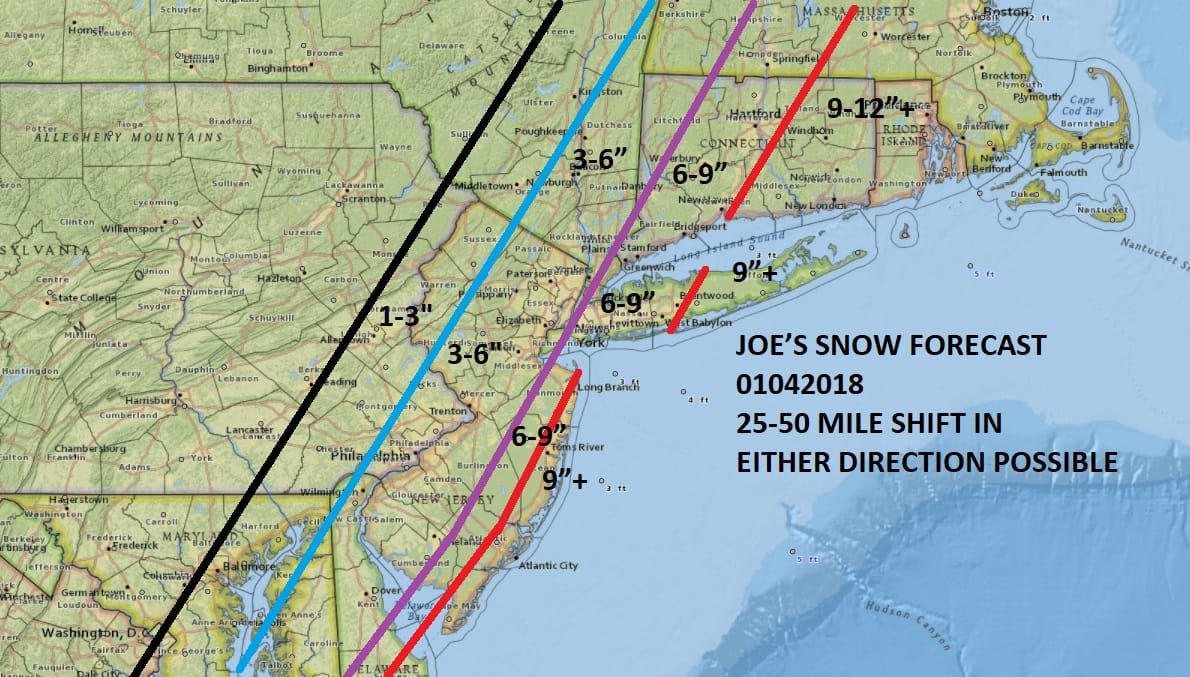
JOE’S SNOW FORECAST THURSDAY 01042018
This morning we have no issues with a sunny start to the day though it is cold with temperatures in the teens. We could see readings in the upper 20s to near 30 this afternoon. The upper air systems that will trigger this major storm are sweeping around the OhIo Valley with the southern stream system moving through the Southeast US. Low pressure is now begun to develop just north of the Bahamas and it will commence its northward track. Clouds will arrive here later this afternoon and snow will develop overnight as it sweeps in from the southeast and heads northwestward with the western edge reaching Eastern Pennsylvania. Temperatures overnight will be in the 20s.
SATELLITE LOOP

REGIONAL RADAR

Tomorrow it is snow and wind..especially wind. That will become a big deal along coastal areas and near blizzard conditions are possible over coastal New Jersey and Long Island with heavy snow falling, winds gusting to 50 mph or more and temperatures falling through the 20s.

This major storm will be moving away tomorrow evening with snow ending from southwest to northeast beginning later in the afternoon across Western & Southern New Jersey and during the evening across Connecticut & Long Island.
SERIOUS ARCTIC BLAST FOLLOWS THURSDAY NIGHT THROUGH SUNDAY
Behind this storm is the coldest of the cold arctic air masses we have been experiencing since Christmas. This one will likely take temperatures down to the single digits Friday morning and not much above 10 in most places Friday afternoon. Saturday morning look for temperatures to be below zero over much of the Northeast & Middle Atlantic States including the major cities like Washington Baltimore Philadelphia, NYC, Hartford & Boston especially where there is a solid snow cover on the ground.
WINTER STORM WARNING NAM MODEL
FRIDAY MORNING FORECAST TEMPERATURES
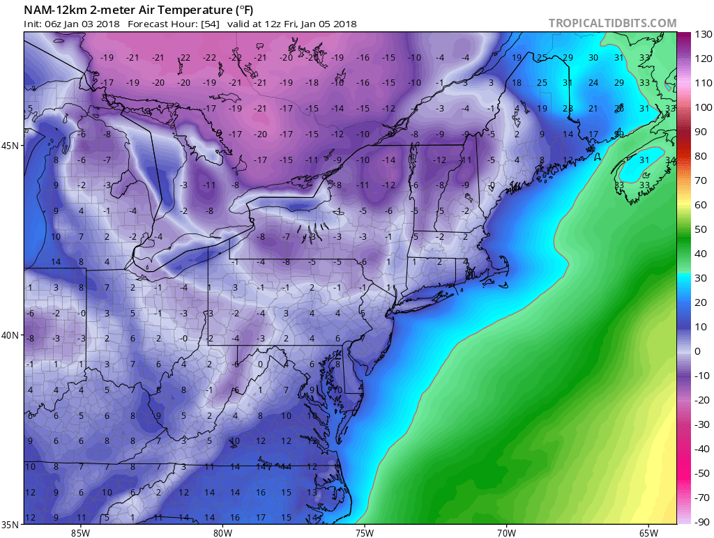
Some areas may see lows below -10! in this latest stretch of brutally cold air that is coming behind this major storm. We should begin to moderate back to 20 or so Sunday and perhaps we could see a day or 2 next week where we go above freezing.
 GET JOE A CIGAR IF YOU LIKE

FiOS1 News Weather Forecast For Long Island
FiOS1 News Weather Forecast For New Jersey
FiOS1 News Weather Forecast For Hudson Valley


