Snow Forecasts Raised Higher In Coastal Areas 01042018
Snow Forecasts Raised Higher In Coastal Areas 01042018
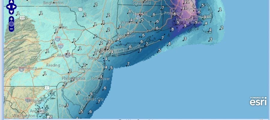
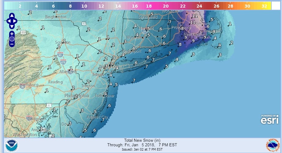
National Weather Service snow forecasts are up and amounts have been adjusted a bit higher for coastal areas of the eastern half of Long Island and Coastal New Jersey as well as Southeastern New England. Weather models today have nudged precipitation amounts a little higher as the surface low is forecast to jog slightly more westward. There is plenty of time for wobbles in either direction though west trends late in the game have become quite common.
WIND GUST FORECAST FOR THURSDAY

Winds are going to become a big issue especially along coastal areas and gusts over 40 mph will be quite common. In areas where there is more snow this could create near blizzard conditions at times with visibility reduced to near zero at times. The highest risk for this would be in Coastal New Jersey and Long Island especially Suffolk County and Southeastern New England.

GET JOE A CIGAR SO HE CAN RELAX!
NEW YORK CITY AND VICINITY SNOW

NEW YORK CITY & VICINITY ICE

NEW JERSEY & PARTS OF NE PA

SOUTHERN AND SOUTHEAST NEW ENGLAND

NORTHERN NEW ENGLAND

WESTERN NEW ENGLAND

MIDDLE AND UPPER HUDSON VALLEY

CENTRAL NEW YORK & NE PA

WESTERN NEW YORK

CENTRAL & SOUTH CENTRAL PA

VIRGINIA & MARYLAND

DAILY NORTHEAST SNOWFALL

Please be advised that these are National Weather Service Forecast Maps and they auto update. Each office may update at different times and some offices are slower to update then others. Maps are usually updated before 5am and & 5pm however they may be updated at other times depending on forecast conditions. These are not my forecasts. My forecasts can be found on the JOE’S SNOWFORECAST PAGE. Individual forecasts for specific areas may also be found when conditions warrant on the my area forecasts. Those can be found on the website menu. Click on forecasts and then select your specific area.