DOWNLOAD MY NEW FREE JOESTRADAMUS WEATHER APP FOR ANDROID
THE APP IS ABSOLUTELY FREE TO ALL BUT CONSIDERING SUBSCRIBING TO PATREON FOR A WEATHER EXPERIENCE FREE OF ADS, EXCLUSIVE VIDEOS FOR MEMBERS ONLY AND MUCH MORE…STARTS AT $2 A MONTH..MESSAGE ME AT ANY TIME
Wind Blown Bad Hair Day Weekend Snow Appears Weak
it is another day of howling northwest winds thanks to a deep storm sitting just east of Maine and High Pressure just north of the Great Lakes. The pressure gradient is extremely tight and shows no signs of relaxing today so expect a wind blown bad hair day with gusts to 35 to 40 mph at times especially near the coast. A strong upper trough is also moving by today which explains the clouds that are around. I wouldn’t rule out the possibility of a snow shower or two either since the lake effect snow machine seems to be working overtime today.
EASTERN SATELLITE

REGIONAL RADAR

The regional radar this morning shows areas of snow showers upstate moving southward and they are even showing up on some of the local radars. This will likely continue for much of the day along with the gusty winds and temperatures just in the 30s at best.
LOCAL RADAR NEW YORK CITY

LOCAL RADAR PHILADELPHIA


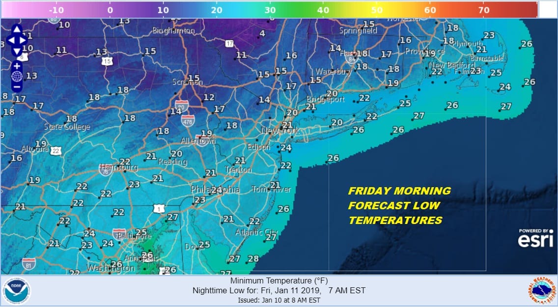
The stair step decline in temperatures continues and will take a bigger drop tonight as skies partially clear. Friday morning lows will be in the teens to lower 20s everywhere. Combine that with a gusty wind overnight to 30 mph at times and wind chills will be down in the low teens and single digits by daybreak.
Winds will begin to ease on Friday but it will still be a bit breezy. Couple that with temperatures that many not get out of the 20s in many areas and you have the makings for a very cold day indeed. At least Friday we should see plenty of sunshine.
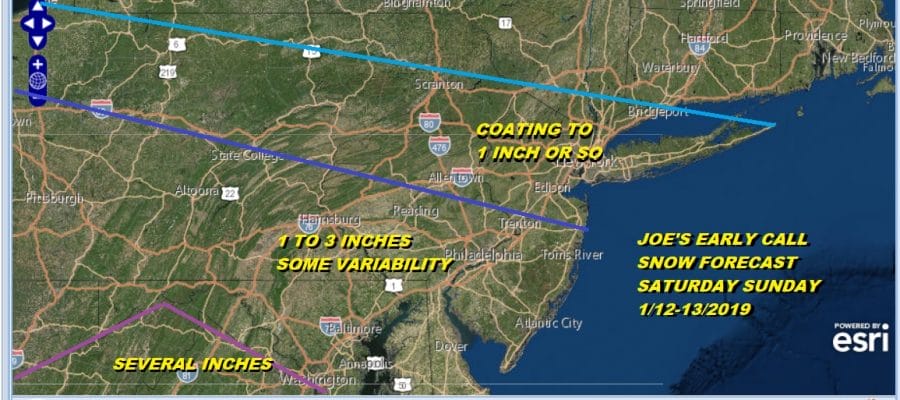
Now comes the weekend as we watch low pressure come out of the Southern Plains as heads eastward across the lower Tennessee Valley and then to the Carolina’s. While there will be a rather robust snowfall for the Middle Mississippi and Ohio Valley, the system will be weakening to some extent as it comes eastward. There is a ton of dry air that is coming down from the vast arctic dessert to the far north. Snow will attempt to move eastward and much of the first shot of snow Saturday night into Sunday morning will likely get eaten away by the dry air.
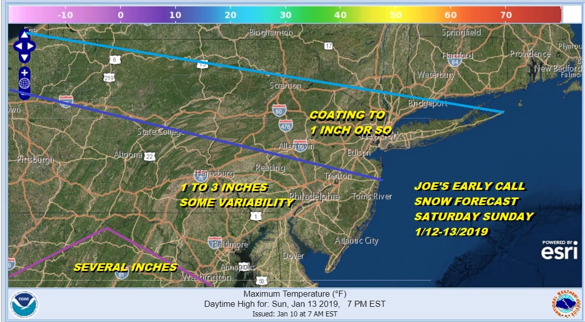
Between the dry air and the not so bullish view of the remaining low as it develops near the Carolina Coast leads to a subdued early call snow forecast. There will be a sharp cut off just north of NYC and we are talking about a coating to an inch here and nothing more. From 195 southward in New Jersey and extending northwestward into Pennsylvania this could be a 1 to 3 inch zone. Several inches or more are possible southwest of Washington DC when this is all set and done. Right now this doesn’t look to me to be something that winds up seeing an upside surprise. While all this is or isn’t happening temperatures over the weekend will likely have a tough time getting out of the 20s.
MANY THANKS TO TROPICAL TIDBITS FOR THE USE OF MAPS
Please note that with regards to any tropical storms or hurricanes, should a storm be threatening, please consult your local National Weather Service office or your local government officials about what action you should be taking to protect life and property.


