Wind Advisories Continue Lake Effect Snows Upstate Colder Air This Weekend

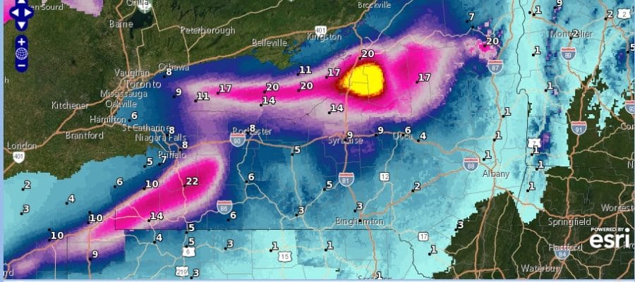
The winds today wound up being stronger than advertised prompting NWS to issue Wind Advisories this morning and they continue this evening in the Hudson Valley and inland in Pennsylvania but they have been discontinued for New Jersey, Long Island, the lower Hudson Valley and Southern New England . We are still seeing gusts over 40 mph at times. This is all thanks to a strong storm in Southeastern Canada that is producing tons of lake effect snows in Western and North Central NY as well as in Northwest Pennsylvania. Some snow even extends south into Southwest Pennsylvania. The lake effect machine will remain busy as will our winds but at least skies have partially cleared out. Temperatures are now in the 30s and falling and we should bottom in the mid 20s to lower 30s Friday morning.
SATELLITE

REGIONAL RADAR

Friday looks to be a day of sun and clouds. The regional radar is showing bands of lake effect snows moving east and some of the clouds will likely survive the trip east. This should cut back on the sunshine on Friday. Highs will be in the upper 30s and lower 40s.
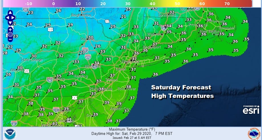
The weekend will be cold and dry. Saturday looks to be the colder of the two weekend days with highs just in the 30s after a cold Friday night and followed by a cold Saturday night with lows in the low to mid 20s and upper teens in cold spots. Sunday’ highs with sunshine and arriving clouds will be in the 30s to around 40.

Monday we go back to gloom and doom as we have another wash rinse repeat scenario setting up Two weak lows followed by a stronger one will bring the risk for scattered showers later Monday. Wave two will bring more showers on Tuesday with a cold front. The third and final wave will be the strongest of the bunch for later Wednesday. All of the precipitation at least for the I-95 corridor will be rain (as usual) and snow will be minimal until perhaps the last wave on Wednesday for northern areas. We will be taking a closer look at all of this over the weekend.
BE SURE TO DOWNLOAD THE FREE METEOROLOGIST JOE CIOFFI WEATHER APP &
ANGRY BEN’S FREE WEATHER APP “THE ANGRY WEATHERMAN!
MANY THANKS TO TROPICAL TIDBITS FOR THE USE OF MAPS
Please note that with regards to any severe weather, tropical storms, or hurricanes, should a storm be threatening, please consult your local National Weather Service office or your local government officials about what action you should be taking to protect life and property.


