White Christmas Possibilities Northeast Middle Atlantic

White Christmas Possibilities Northeast Middle Atlantic
There is so much variability in the models lately and that variability continues today thanks to the fact that pressure patterns in the important areas in North America continue to remain and are forecast to be at extreme levels. When you have pressure patterns and oscillations running 3 and 4 times normal it sends weather models into a tizzy and makes forecasting the long range extremely difficult.
WHITE CHRISTMAS TELECONNECTIONS

The standout here is the East Pacific oscillation which rides down to a minus 300 reading which means cold air coming into the continental US as we near Christmas however the Pacific North America index being negative is not favorable for the East. Bear in mind these indices adjust and change as we get closer and are based on ensembles of the models which gives you an average forecast and not a specific one. The North Atlantic Oscillation which is the least important is strongly positive so there is no blocking. Remember blocking is not required for cold and snow. The East Pacific Oscillation to me is the most important of all the indices. This takes us to the weather outlook going forward which is really no clearer now that it was yesterday or the day before or the day before that, etc etc etc.
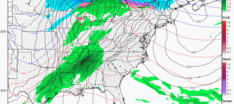
WHITE CHRISTMAS POSSIBILITIES GFS MODEL FRIDAY INTO SUNDAY
CLICK TO ANIMATE
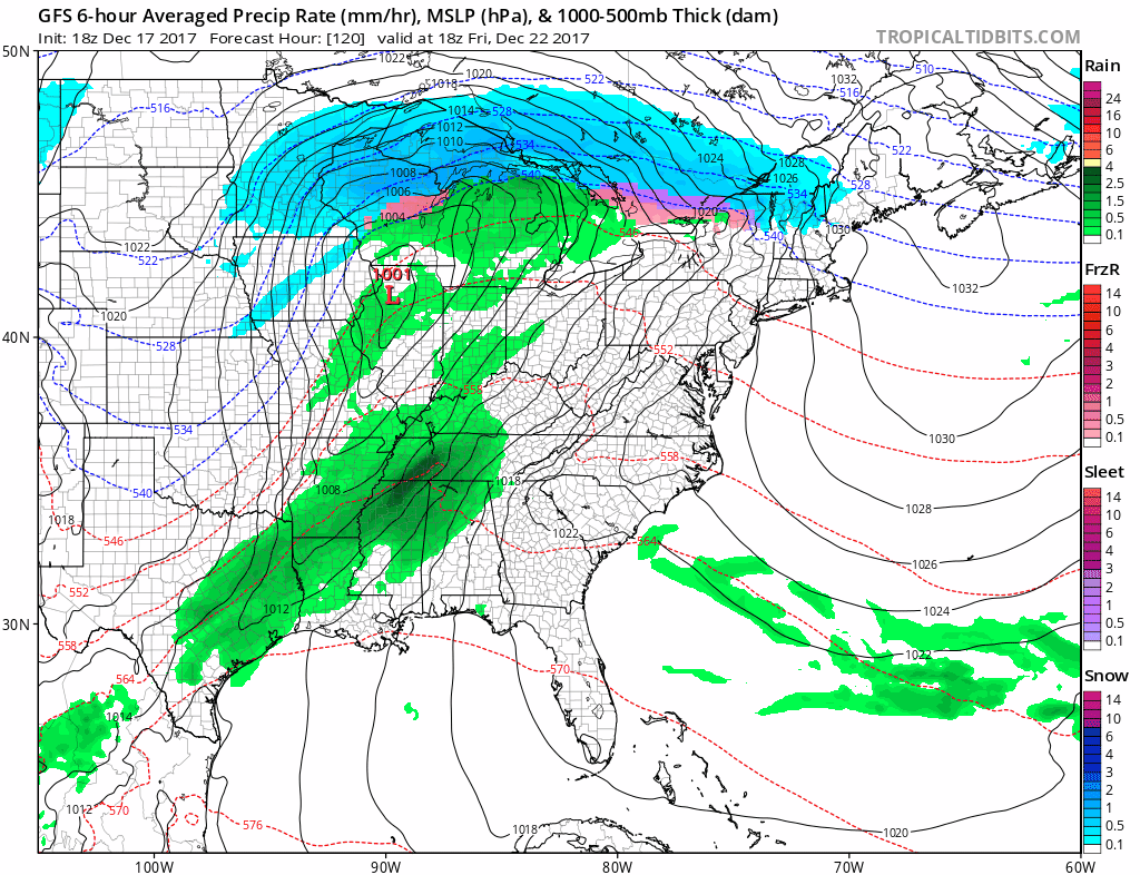
The next important weather maker will be another cold front that approaches on Saturday with rain as low pressure heads to the Great Lakes and eventually into Eastern Canada. That rain should be done by late Saturday with the front stalling to our south. Christmas Eve and Christmas Day will hinge on the front, where it stalls, and whether a wave develops on it or not. Weather models have been doing 180 degree flips for the last week on this. Very cold air will be pouring into the U.S. but models can’t seem to decide how much of that colder air moves eastward. The models have been so unstable with all the pressure patterns in the Pacific pushed to extreme levels.
LATEST MODEL RUN SHOWING SNOW CHRISTMAS EVE & CHRISTMAS DAY CLICK TO ANIMATE
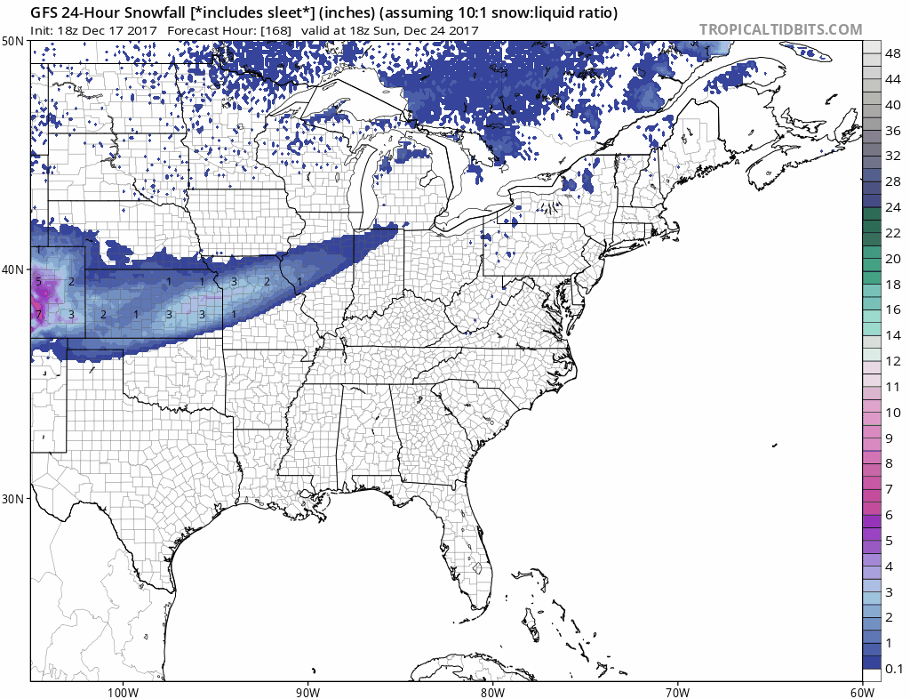
The last 2 runs of the GFS model were showing a warmer look as the map above indicates. When you click on it you will see which areas are forecast to see 24 hour snow fall Christmas Eve & Christmas Day. This stands in strong contrast to colder models last night which had snow much further south.
OVERNIGHT GFS MODEL SNOW CHRISTMAS EVE & CHRISTMAS DAY CLICK TO ANIMATE
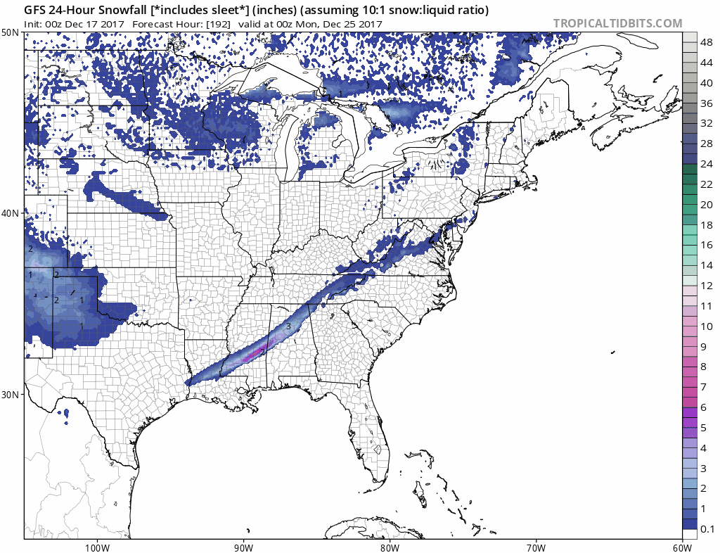
The question of how much cold air comes into the Eastern US remains in flux. Models are going to have to lock in soon as to which way this is going to go. What we know for sure is that Friday night into Saturday we will see rain. After that is going to depend on how far south the front gets and how much of the cold air coming down from Canada pushes to the east. Don’t expect much clarity on this for at least another couple of days.
MANY THANKS TO TROPICAL TIDBITS FOR THE WONDERFUL USE OF THE MAPS

GET JOE A CIGAR IF YOU LIKE!
FiOS1 News Weather Forecast For Long Island
FiOS1 News Weather Forecast For New Jersey
FiOS1 News Weather Forecast For Hudson Valley
NATIONAL WEATHER SERVICE SNOW FORECASTS
LATEST JOESTRADAMUS ON THE LONG RANGE
Weather App

Don’t be without Meteorologist Joe Cioffi’s weather app. It is really a meteorologist app because you get my forecasts and my analysis and not some automated computer generated forecast based on the GFS model. This is why your app forecast changes every 6 hours. It is model driven with no human input at all. It gives you an icon, a temperature and no insight whatsoever.
It is a complete weather app to suit your forecast needs. All the weather information you need is right on your phone. Android or I-phone, use it to keep track of all the latest weather information and forecasts. This weather app is also free of advertising so you don’t have to worry about security issues with your device. An accurate forecast and no worries that your device is being compromised.
Use it in conjunction with my website and my facebook and twitter and you have complete weather coverage of all the latest weather and the long range outlook. The website has been redone and upgraded. Its easy to use and everything is archived so you can see how well Joe does or doesn’t do when it comes to forecasts and outlooks.
Just click on the google play button or the apple store button on the sidebar for my app which is on My Weather Concierge. Download the app for free. Subscribe to my forecasts on an ad free environment for just 99 cents a month.
Get my forecasts in the palm of your hand for less than the cost of a cup of Joe!