Winter Weather Advisory Overnight Monday Morning
Winter Weather Advisory Overnight Monday Morning
Winter Weather Advisory Overnight Monday Morning

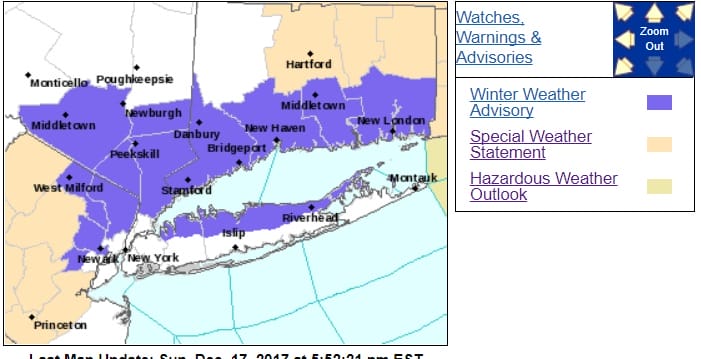
Winter Weather Advisory is posted for Northeastern New Jersey, the north shore of Long Island, The Hudson Valley and Connecticut south of Route 84. We have a weakening area of light precipitation that is showing up on the radars below. The satellite loop shows lots of clouds all around the area. The air is cold enough that there could be some light snow developing over parts of the area tonight. Warmer air will move in aloft and change it over to sleet and freezing rain. Precipitation amounts will be on the light side however it could create some patchy slick spots overnight and Monday morning for the start of the commute. Temperatures in many areas are near or below freezing while New Jersey south of Route 78 and the warm urban areas should be safe from any serious issues overnight.
SATELLITE LOOP

REGIONAL RADAR

LOCAL RADAR NEW YORK CITY

LOCAL RADAR PHILADELPHIA


After tomorrow morning the precipitation should be done and leftover clouds should give way to some breaks of sun with highs in the 40s. The next cold front arrives Tuesday but it should be free of moisture other than a few clouds. Highs could reach the upper 40s to lower 50s before colder air arrives Tuesday night. Wednesday Thursday and the start of Friday should be chilly with highs in the 30s both Wednesday and Thursday and nights in the 20s. We should see some sunshine both Wednesday and Thursday.
 GET JOE A CIGAR IF YOU LIKE

FiOS1 News Weather Forecast For Long Island
FiOS1 News Weather Forecast For New Jersey
FiOS1 News Weather Forecast For Hudson Valley


