Weather Models Winter Pattern Developing Has Forecast Challenges

Weather Models Winter Pattern Developing Has Forecast Challenges
After 2 days of relative consistency in weather models we are seeing some divergence today between the European model & the GFS model. The two models are fairly consistent with the next 5 days which really doesn’t help matters since it is the 5 days that follow that are problematic in the forecast. Both models show a strong cold front approaching next Wednesday and then the models diverge. First things first however are the teleconnection indices that still show that there is potential for something to happen around the December 9-11 time frame.

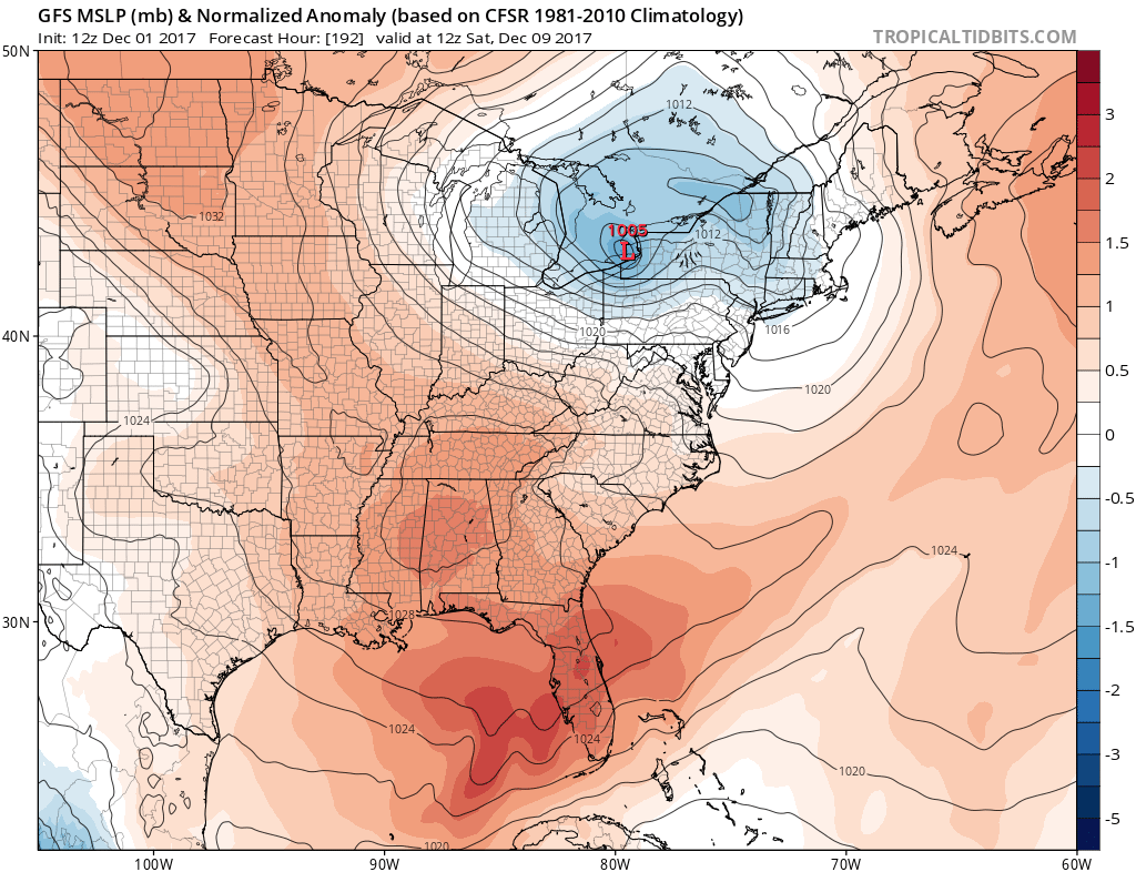
The Pacific North America index remains very strongly positive right through the middle of December. The North Atlantic Oscillation rises from a strong negative reading this weekend to near neutral rather rapidly in the Dec 9-11 period. Often times systems tend to develop in the East when this happens. Yesterday the GFS was responding to this by showing a developing second wave on a cold front late next week.

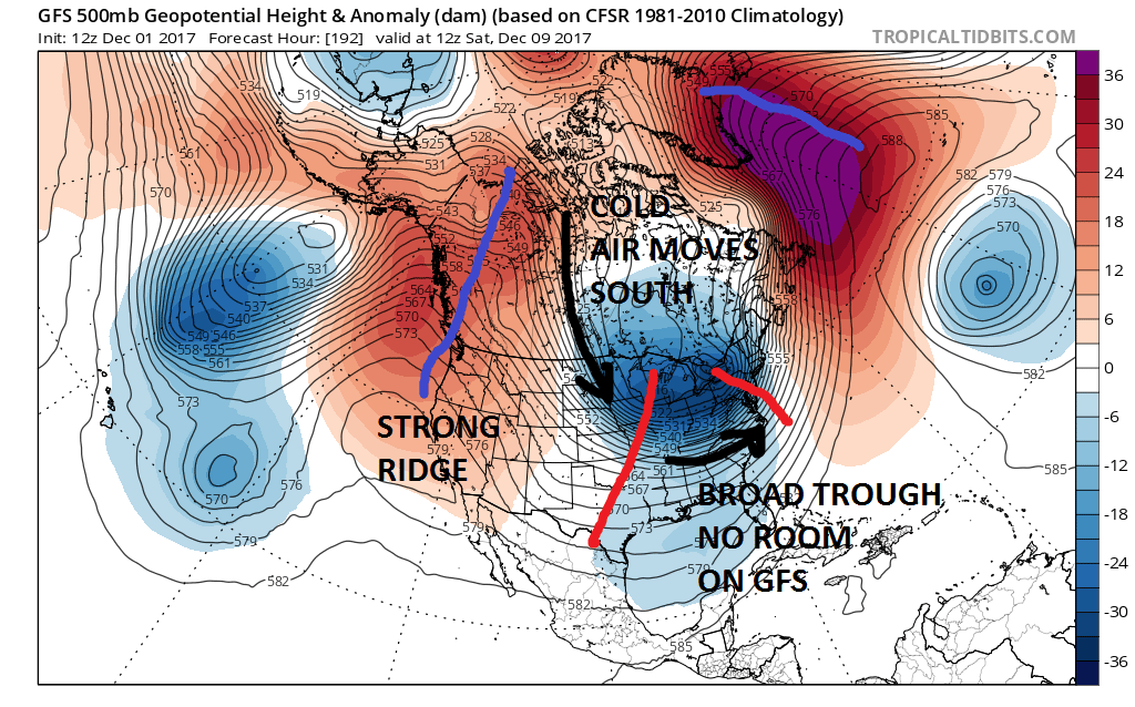
Yesterday’s GFS model run was perhaps a bit fast with this idea but since then it has been showing a much flatter low much further offshore with no real consequence. The GFS simply overwhelms the East with cold air which would leave no room for anything to happen. The upper flow shows a broad jet stream far to the south with re-enforcing surges of cold air coming down out of Canada.
GFS WEATHER MODEL SATURDAY DECEMBER 9TH
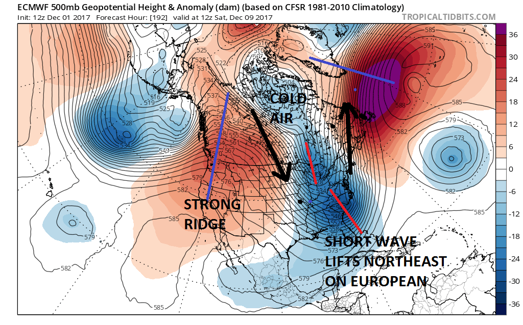
The European however has a different idea. It brings cold air beginning later Wednesday but it hangs the main trough back to the west so that it takes a long time for the front to move offshore. The European still has it precipitating into Thursday morning with a change to sleet and snow at the end inland of the coast.
EUROPEAN WEATHER MODEL SATURDAY DECEMBER 9TH
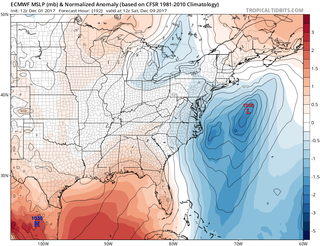
The European handles things completely different than the GFS as it argues for another disturbance swinging around at the bottom of the trough and then lifting up the East Coast into the colder air. Both model solutions seem plausible. I continue to lean to the idea that a second wave on the cold front is a possibility for the end of next week. However it might be nice to have some model consensus or at least have them reasonably close. But they never make things easy do they? It would seem that once again models handle the strong upper high in the Atlantic differently or at least different enough to create these model divergences. The Pacific side of the equation seems similar on both models. The surface maps below show the differences quite well.
Needless to say it is very early and we have a long way to go on this.
MANY THANKS TO TROPICAL TIDBITS FOR THE WONDERFUL USE OF THE MAPS

GET JOE A CIGAR IF YOU LIKE!
FiOS1 News Weather Forecast For Long Island
FiOS1 News Weather Forecast For New Jersey
FiOS1 News Weather Forecast For Hudson Valley
NATIONAL WEATHER SERVICE SNOW FORECASTS
LATEST JOESTRADAMUS ON THE LONG RANGE
Weather App

Don’t be without Meteorologist Joe Cioffi’s weather app. It is really a meteorologist app because you get my forecasts and my analysis and not some automated computer generated forecast based on the GFS model. This is why your app forecast changes every 6 hours. It is model driven with no human input at all. It gives you an icon, a temperature and no insight whatsoever.
It is a complete weather app to suit your forecast needs. All the weather information you need is right on your phone. Android or I-phone, use it to keep track of all the latest weather information and forecasts. This weather app is also free of advertising so you don’t have to worry about security issues with your device. An accurate forecast and no worries that your device is being compromised.
Use it in conjunction with my website and my facebook and twitter and you have complete weather coverage of all the latest weather and the long range outlook. The website has been redone and upgraded. Its easy to use and everything is archived so you can see how well Joe does or doesn’t do when it comes to forecasts and outlooks.
Just click on the google play button or the apple store button on the sidebar for my app which is on My Weather Concierge. Download the app for free. Subscribe to my forecasts on an ad free environment for just 99 cents a month.
Get my forecasts in the palm of your hand for less than the cost of a cup of Joe!