Weather Improves Late Today More Rain Late Wednesday Thursday
Holiday Weekend Forecast
The gloom and doom of Monday continues today with rain that is around. We are obviously socked in with lots of clouds and it doesn’t appear to be much hope for any genuine improvement later today into this evening. To find any sunshine at all you have to head down to Florida!
SATELLITE

REGIONAL RADAR

The regional radar is still showing rain overhead this afternoon however the back edge of the rain is making some progress eastward. We should see that rain pull out however to the south the rain will likely hang on into tonight. Of course this sets up the next round of precipitation for later Wednesday into Thursday.
LOCAL RADAR NEW YORK CITY

LOCAL RADAR PHILADELPHIA


Temperatures are holding in the gloomy raw 40s. Perhaps tonight clouds could thin out a bit as slightly colder and drier air moves in. Lows will be in the upper 20s to mid 30s. Clouds will increase again tomorrow as the next low heads up the west side of the Appalachians and precipitation arrives late in the day or Wednesday evening. Highs will likely be just into the 40s with 30s north and west of the coast.

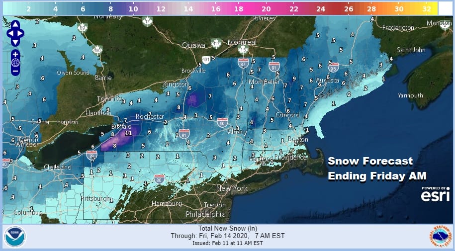
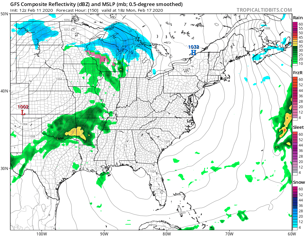
When precipitation arrives well north and west of NYC and Philadelphia, it could start briefly as some snow or sleet before it goes over to rain. For snow lovers and skiers the areas in upstate NY and into Northern New England will see accumulating snows from this. Also we can add a little lake effect for Western NY and Western Pennsylvania as the low exits Thursday night into Friday.
Rain Wednesday night should last on and off into Thursday afternoon until the cold front passes. Then much colder air will arrive. Temperatures will rise into the upper 40s to mid 50s before the front goes by. Weather conditions improve late Thursday and Thursday night but temperatures will be heading south into the 20s by Friday morning. Friday temperatures won’t be going anywhere as the coldest air arrives for Friday night into Saturday morning.
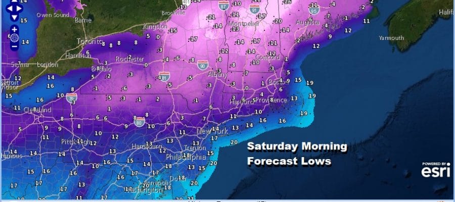
Saturday morning will likely be the coldest day of the month and probably the entire winter for the Northeast with lows in the teens and single digits along the coast and below zero in upstate NY, well below zero in interior New England. At least we will have sunshine Saturday with many areas having a tough time getting out of the 20s except for perhaps Southeast Pennsylvania and Southern New Jersey where you might crack the freezing mark.
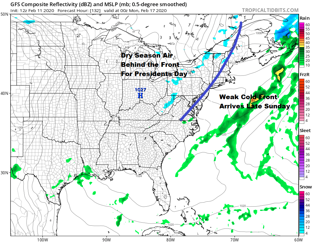
We should see temperatures rebound Sunday as the very cold air pulls out fast. Another weak cold front will likely put us in some cloud cover ahead of it but the front is dry. Highs Sunday should get back into the 40s. The air behind the front is seasonal in nature so Monday President’s day we should see some sunshine with highs in the 40s. I’m nudging the temperatures down a shade for Monday.
Wash rinse repeat is the story for later next week and it looks like we will see something similar to what we are going through now. A cold front with showers Tuesday into Wednesday and then it stalls with waves to follow. It is simply more of the same.
BE SURE TO DOWNLOAD THE FREE METEOROLOGIST JOE CIOFFI WEATHER APP &
ANGRY BEN’S FREE WEATHER APP “THE ANGRY WEATHERMAN!
MANY THANKS TO TROPICAL TIDBITS FOR THE USE OF MAPS
Please note that with regards to any severe weather, tropical storms, or hurricanes, should a storm be threatening, please consult your local National Weather Service office or your local government officials about what action you should be taking to protect life and property.


