Wait To Plant Vegetables Until After Mother’s Day Cold Patter Long Range Lasting Into Mid Month
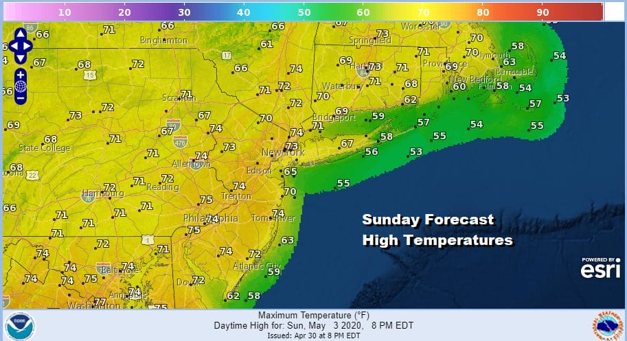
We did see some showers move through overnight and moved out right on schedule. Now we will go to a mix of sun and clouds for the rest of this Sunday but a lot depends on those clouds that lie east west across Pennsylvania and New Jersey south into Maryland Delaware and Virginia. To the north dry air and sunshine cover Northern Pennsylvania and much of NY State. It will be a matter of how far south the cloud line sinks to determine how much if any sun you will see today. Temperatures should top in the 70s this afternoon.
SATELLITE

REGIONAL RADAR

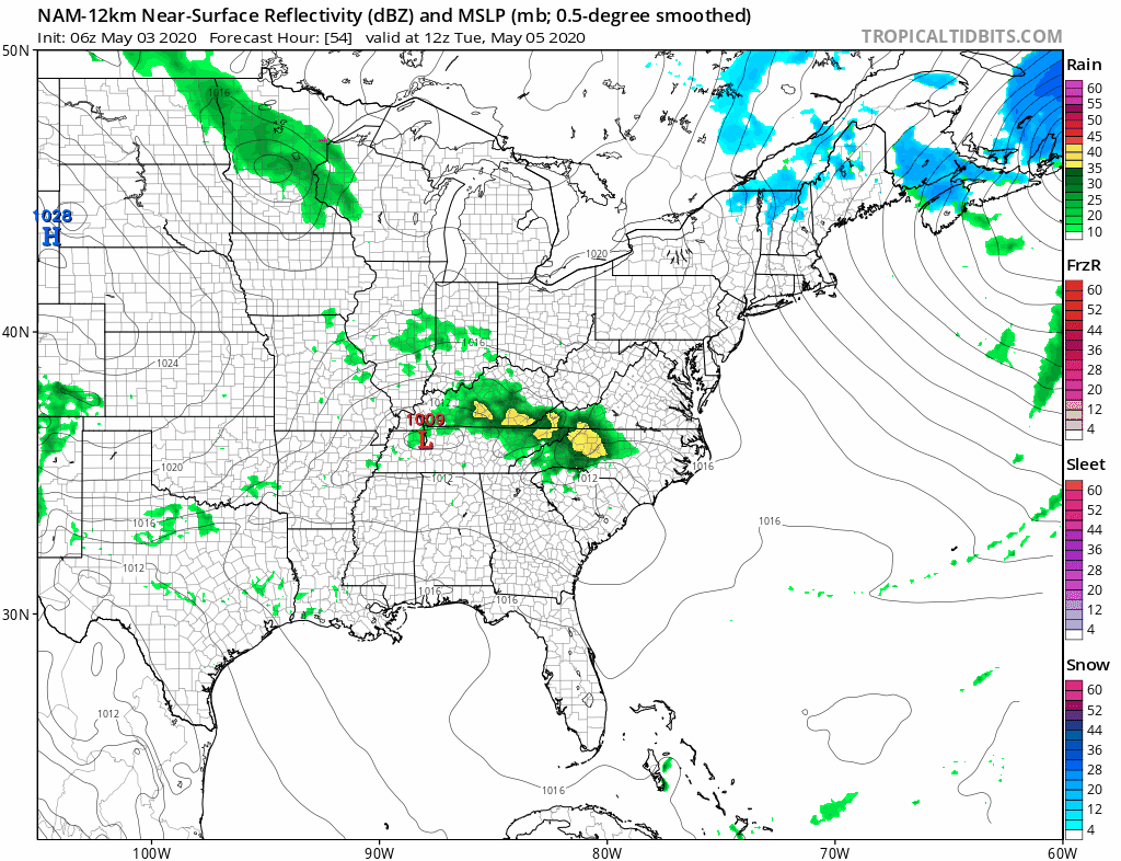
There are some showers moving west to east across Northern West Virginia east to Delaware and these could pose issues there for much of the day. Not much is showing up to the north where the overnight showers are long gone.
LOCAL RADAR NEW YORK CITY

LOCAL RADAR PHILADELPHIA


All of this leads to a strengthening storm system to the northeast and another wave that develops off the Delaware coast tonight and moves east and offshore. Some showers overnight could graze Delaware and Southern New Jersey but everyone else should be dry. Monday brings a gusty wind and some sunshine but it also brings much cooler temperatures with highs in the low to mid 60s.
Chilly air will be the theme all week. Now remember this time of year average highs are in the mid to upper 60s and in another 8 or 9 days most of the area will see average highs above 70. So if we wind up a day with temperatures just in the 60s or even not getting out of the 50s, that would be the same as a day in the dead of winter with temps by day in the 20s. That said it seems we could be dry for much of this week even though we do get into a bit of an onshore flow situation for Tuesday night and Wednesday. The strong northern jet stream seems to suppress lows to the south which keeps rain out. Tuesday we will see sunshine with diminishing winds and then some late day arriving clouds. Highs will be in the upper 50s to lower 60s. Wednesday we will just go cloudy for now with highs in the 50s.
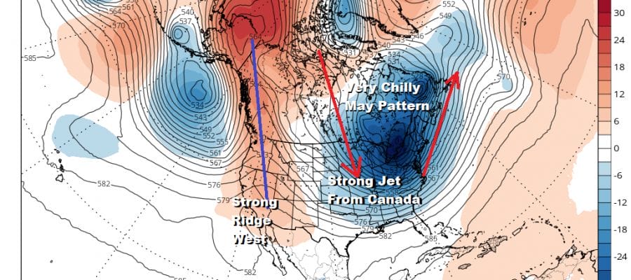
Friday brings an approaching cold front and a wave that will likely develop on that front and then head up into New England. This is going to be followed by a very chilly air mass for next weekend (which includes Mother’s Day. The upper air jet stream pattern is about as cold a look as you can get for this time of year.
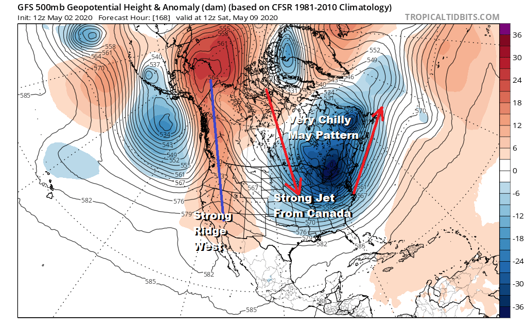
The strong flow from Canada is solid with a straight pipeline from the Canadian Northwest. We will probably deal with showers late Friday into early Saturday with wind cold weather to follow for later Saturday and next Sunday. We could see high temperatures both Saturday and Sunday Mother’s Day not out of the 50s and we will have to see whether late season freezes are possible next Saturday night. Wait before planting tomatoes!
BE SURE TO DOWNLOAD THE FREE METEOROLOGIST JOE CIOFFI WEATHER APP &
ANGRY BEN’S FREE WEATHER APP “THE ANGRY WEATHERMAN!
MANY THANKS TO TROPICAL TIDBITS FOR THE USE OF MAPS
Please note that with regards to any severe weather, tropical storms, or hurricanes, should a storm be threatening, please consult your local National Weather Service office or your local government officials about what action you should be taking to protect life and property.


