
Tropical Storm Watch Tropical Depression 8
LATEST TROPICAL WEATHER VIDEO ON TROPICAL DEPRESSION 8, 9 & HURRICANE GASTON
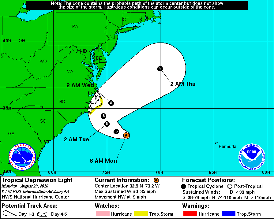
TROPICAL STORM WATCH COASTAL NORTH CAROLINA
TROPICAL DEPRESSION 8 MOVING NORTHWEST

The latest reports from an Air Force plane show the depression rather weak and you can see on the loop above the center of the circulation. However we have noticed some thunderstorms are beginning to flare up in and around the center again so this will need to be watched this afternoon. Conditions are becoming more favorable as the depression gets closer to the coast. We have a moist tropical environment and warm water temperatures with less wind shear. Tropical Storm Watch is posted for the coast of North Carolina.
...HURRICANE HUNTER AIRCRAFT FINDS THAT THE DEPRESSION REMAINS
WEAK...


SUMMARY OF 800 AM EDT...1200 UTC...INFORMATION
----------------------------------------------
LOCATION...32.9N 73.2W
ABOUT 210 MI...340 KM SE OF CAPE HATTERAS NORTH CAROLINA
MAXIMUM SUSTAINED WINDS...35 MPH...55 KM/H
PRESENT MOVEMENT...NW OR 310 DEGREES AT 9 MPH...15 KM/H
MINIMUM CENTRAL PRESSURE...1011 MB...29.86 INCHES


WATCHES AND WARNINGS
--------------------
CHANGES WITH THIS ADVISORY:

None.

SUMMARY OF WATCHES AND WARNINGS IN EFFECT:

A Tropical Storm Watch is in effect for...
* The coast of North Carolina from Cape Lookout to Oregon Inlet

A Tropical Storm Watch means that tropical storm conditions are
possible within the watch area, generally within 48 hours.

Interests elsewhere along the Outer Banks of North Carolina should
monitor the progress of the depression.  Additional watches or
warnings may be required later today.

For storm information specific to your area, including possible
inland watches and warnings, please monitor products issued by your
local National Weather Service forecast office.


DISCUSSION AND 48-HOUR OUTLOOK
------------------------------
At 800 AM EDT (1200 UTC), the center of Tropical Depression Eight
was located near latitude 32.9 North, longitude 73.2 West.  The
depression is moving toward the northwest near 9 mph (15 km/h).
This general motion with a slower forward speed is expected later
today, with a turn toward the north forecast on Tuesday or Tuesday
night.  On the forecast track, the center of the depression will be
near the Outer Banks of North Carolina late Tuesday.

Maximum sustained winds are near 35 mph (55 km/h) with higher
gusts. Slow strengthening is forecast during the next 48 hours, and
the depression is expected to become a tropical storm by tonight.

The minimum central pressure reported by the Air Force Reserve
Hurricane Hunter is 1011 mb (29.86 inches).
There has been no real change in any of the forecasts over the next few days. The depression is forecast to strengthen into a tropical storm and then hook to the right. With a weather front dropping down from the north and upper air winds turning westerly across the Middle Atlantic and Northeast, this makes total senses.
Tropical Depression 9 is in the Gulf of Mexico and this could become a tropical storm later today or tonight. Here is the latest information on Tropical Depression 9.
FiOS1 News Weather Forecast For Long Island
FiOS1 News Weather Forecast For New Jersey
FiOS1 News Weather Forecast For Hudson Valley
NATIONAL WEATHER SERVICE SNOW FORECASTS
LATEST JOESTRADAMUS ON THE LONG RANGE
Weather App

Don’t be without Meteorologist Joe Cioffi’s weather app. It is really a meteorologist app because you get my forecasts and my analysis and not some automated computer generated forecast based on the GFS model. This is why your app forecast changes every 6 hours. It is model driven with no human input at all. It gives you an icon, a temperature and no insight whatsoever.
It is a complete weather app to suit your forecast needs. All the weather information you need is right on your phone. Android or I-phone, use it to keep track of all the latest weather information and forecasts. This weather app is also free of advertising so you don’t have to worry about security issues with your device. An accurate forecast and no worries that your device is being compromised.
Use it in conjunction with my website and my facebook and twitter and you have complete weather coverage of all the latest weather and the long range outlook. The website has been redone and upgraded. Its easy to use and everything is archived so you can see how well Joe does or doesn’t do when it comes to forecasts and outlooks.
Just click on the google play button or the apple store button on the sidebar for my app which is on My Weather Concierge. Download the app for free. Subscribe to my forecasts on an ad free environment for just 99 cents a month.
Get my forecasts in the palm of your hand for less than the cost of a cup of Joe!
![]()
![]()