Tropical Depression 9 Gulf of Mexico Latest Tropical Weather Video Monday 08292016
Tropical Depression 9 Moving Westward

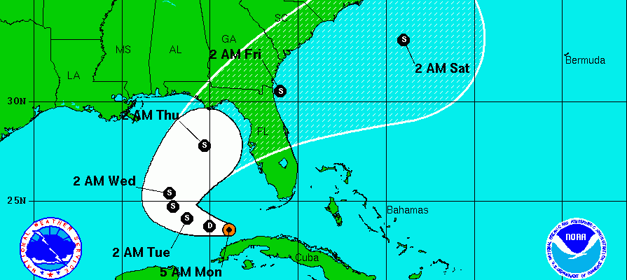
Tropical Depression 9 did not strengthen overnight and actually took on a bit of a ragged appearance. However looking at it this morning we see that it may be trying to organize a bit as thunderstorms seem to be blossoming some to the north of the circulation center. We will have to see this trend continue during the day.
...POORLY ORGANIZED DEPRESSION MOVING INTO THE EXTREME SOUTHEASTERN
GULF OF MEXICO...


SUMMARY OF 500 AM EDT...0900 UTC...INFORMATION
----------------------------------------------
LOCATION...23.5N 83.9W
ABOUT 155 MI...245 KM WSW OF KEY WEST FLORIDA
ABOUT 95 MI...155 KM WNW OF HAVANA CUBA
MAXIMUM SUSTAINED WINDS...35 MPH...55 KM/H
PRESENT MOVEMENT...W OR 275 DEGREES AT 9 MPH...15 KM/H
MINIMUM CENTRAL PRESSURE...1007 MB...29.74 INCHES


WATCHES AND WARNINGS
--------------------
There are no coastal watches or warnings in effect.


DISCUSSION AND 48-HOUR OUTLOOK
------------------------------
At 500 AM EDT (0900 UTC), the center of Tropical Depression Nine was
located near latitude 23.5 North, longitude 83.9 West. The
depression is moving toward the west near 9 mph (15 km/h).  A turn
toward the west-northwest is forecast today, followed by a
slow northwestward motion on Tuesday.  On the forecast track, the
center of the depression will be passing north of the north coast
of western Cuba today, and moving farther into the southeastern Gulf
of Mexico by tonight.

Data from a NOAA reconnaissance aircraft indicate that the maximum
sustained winds are near 35 mph (55 km/h) with higher gusts.  Some
strengthening is forecast during the next 48 hours, and the
depression could become a tropical storm later today or tonight.

The estimated minimum central pressure is 1007 mb (29.74 inches).


HAZARDS AFFECTING LAND
----------------------
RAINFALL:  The depression is expected to produce total rain
accumulations of 4 to 8 inches over Cuba, with isolated amounts of
12 inches possible through Wednesday.  These rains could cause
flash floods and mudslides.  Total rain accumulations of 3 to 5
inches are possible over the southern Florida peninsula and the
Florida Keys through Wednesday.  Isolated maximum amounts of 7
inches could occur over coastal areas of southern Florida and the
Keys.  This rainfall may cause flooding and flash flooding.
Tropical Depression 9 Forecast Track
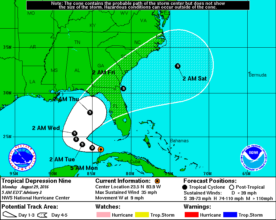
There isn’t too much change in the forecast track for Tropical Depression 9 as it heads into the North Central Gulf and then hooks to the right toward the Florida Coast. This is in line with most of the hurricane model tracks including the global models. Intensity is another matter as conditions are becoming more favorable. However the history with this tropical system has been a long and rather frustrating one to forecast due to dry air intrusions among other things. Shear is forecast to relax today and upper winds turning more south which brings an open flow from the Yucatan Channel. 90 degree water. Everything points to strengthening. We will wait to see what happens later today.


Tropical Depression 8 meanwhile is off the North Carolina coast. Tropical Storm Watches are up for coastal North Carolina. Here is the latest on Tropical Depression 8.
FiOS1 News Weather Forecast For Long Island
FiOS1 News Weather Forecast For New Jersey
FiOS1 News Weather Forecast For Hudson Valley
NATIONAL WEATHER SERVICE SNOW FORECASTS
LATEST JOESTRADAMUS ON THE LONG RANGE
Weather App

Don’t be without Meteorologist Joe Cioffi’s weather app. It is really a meteorologist app because you get my forecasts and my analysis and not some automated computer generated forecast based on the GFS model. This is why your app forecast changes every 6 hours. It is model driven with no human input at all. It gives you an icon, a temperature and no insight whatsoever.
It is a complete weather app to suit your forecast needs. All the weather information you need is right on your phone. Android or I-phone, use it to keep track of all the latest weather information and forecasts. This weather app is also free of advertising so you don’t have to worry about security issues with your device. An accurate forecast and no worries that your device is being compromised.
Use it in conjunction with my website and my facebook and twitter and you have complete weather coverage of all the latest weather and the long range outlook. The website has been redone and upgraded. Its easy to use and everything is archived so you can see how well Joe does or doesn’t do when it comes to forecasts and outlooks.
Just click on the google play button or the apple store button on the sidebar for my app which is on My Weather Concierge. Download the app for free. Subscribe to my forecasts on an ad free environment for just 99 cents a month.
Get my forecasts in the palm of your hand for less than the cost of a cup of Joe!
![]()
![]()