Tropical Storm Warning North Carolina Coast
TROPICAL DEPRESSION 9 LATEST ADVISORY

The race appears to be on as to which depression becomes a tropical storm first. The bet is on Tropical Depression 9 as the latest satellite and recon observations show that it is very close to tropical storm strength.
...DEPRESSION EXPECTED TO BECOME A TROPICAL STORM BY TUESDAY...


SUMMARY OF 500 PM EDT...2100 UTC...INFORMATION
----------------------------------------------
LOCATION...24.0N 84.8W
ABOUT 195 MI...310 KM WSW OF KEY WEST FLORIDA
ABOUT 160 MI...260 KM WNW OF HAVANA CUBA
MAXIMUM SUSTAINED WINDS...35 MPH...55 KM/H
PRESENT MOVEMENT...WNW OR 290 DEGREES AT 5 MPH...7 KM/H
MINIMUM CENTRAL PRESSURE...1007 MB...29.74 INCHES


WATCHES AND WARNINGS
--------------------
There are no coastal watches or warnings in effect.


DISCUSSION AND 48-HOUR OUTLOOK
------------------------------
At 500 PM EDT (2100 UTC), the center of Tropical Depression Nine was
located near latitude 24.0 North, longitude 84.8 West.  The
depression is moving toward the west-northwest near 5 mph (7 km/h)
and a turn toward the north-northwest is expected on Tuesday night
followed by a turn toward the north-northeast on Wednesday.  On the
forecast track, the center will continue to move away from western
Cuba, and move over the eastern Gulf of Mexico over the next
48 hours.

Maximum sustained winds are near 35 mph (55 km/h) with higher gusts.
Some strengthening is forecast during the next 48 hours, and the
depression is expected to become a tropical storm by Tuesday.

The minimum central pressure reported by a NOAA Hurricane Hunter
aircraft is 1007 mb (29.74 inches).


HAZARDS AFFECTING LAND
----------------------
RAINFALL:  The depression is expected to produce additional rain
accumulations of 3 to 6 inches over western Cuba through Wednesday.
Isolated maximum storm-total amounts of 12 inches are possible over
western Cuba.  These rains could cause life-threatening flash floods
and mud slides.  Total rain accumulations of 3 to 7 inches are
possible over much of the Florida peninsula through Thursday.
Isolated maximum amounts of 10 inches are possible along the west
coast of Florida from Naples to Steinhatchee.  This rainfall may
cause flooding and flash flooding.
TROPICAL DEPRESSION 8 LATEST ADVISORY
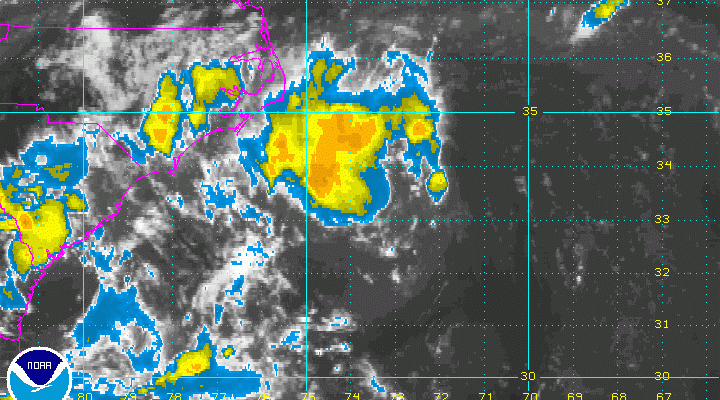
TROPICAL STORM WARNING COASTAL NORTH CAROLINA

Meanwhile thunderstorms continue to increase around the center of tropical depression 8 off the North Carolina coast. The last recon report was not that impressive both from the standpoint of pressure and wind reports. Still the hurricane center has put out a Tropical Storm Warning for parts of the North Carolina coast.
...TROPICAL STORM WARNING ISSUED FOR PARTS OF THE NORTH CAROLINA
COAST...


SUMMARY OF 500 PM EDT...2100 UTC...INFORMATION
----------------------------------------------
LOCATION...33.6N 74.0W
ABOUT 140 MI...225 KM SE OF CAPE HATTERAS NORTH CAROLINA
MAXIMUM SUSTAINED WINDS...35 MPH...55 KM/H
PRESENT MOVEMENT...NW OR 310 DEGREES AT 6 MPH...9 KM/H
MINIMUM CENTRAL PRESSURE...1011 MB...29.86 INCHES


WATCHES AND WARNINGS
--------------------
CHANGES WITH THIS ADVISORY:

A Tropical Storm Warning has been issued for the coast of North
Carolina from Cape Lookout to Oregon Inlet, including Pamlico Sound.

SUMMARY OF WATCHES AND WARNINGS IN EFFECT:

A Tropical Storm Warning is in effect for...
* The coast of North Carolina from Cape Lookout to Oregon Inlet
* Pamlico Sound

A Tropical Storm Warning means that tropical storm conditions are
expected somewhere within the warning area, in this case within 24
hours.

Interests elsewhere along the Outer Banks of North Carolina should
monitor the progress of the depression.  Additional watches or
warnings may be required later today.

For storm information specific to your area, including possible
inland watches and warnings, please monitor products issued by your
local National Weather Service forecast office.


DISCUSSION AND 48-HOUR OUTLOOK
------------------------------
At 500 PM EDT (2100 UTC), the center of Tropical Depression Eight
was located near latitude 33.6 North, longitude 74.0 West.  The
depression is moving toward the northwest near 6 mph (9 km/h).  This
general motion with a slower forward speed is expected later
this evening, with a gradual turn toward the north forecast on
Tuesday. On the forecast track, the center of the depression will be
near the Outer Banks of North Carolina late Tuesday.

Maximum sustained winds remain near 35 mph (55 km/h) with higher
gusts.  Slow strengthening is forecast during the next 48 hours, and
the depression is expected to become a tropical storm by early
Tuesday.

The minimum central pressure estimated from Air Force Reserve
Hurricane Hunter aircraft data is 1011 mb (29.86 inches).


HAZARDS AFFECTING LAND
----------------------
WIND:  Tropical storm conditions are expecting within the warning
area, beginning by Tuesday afternoon.

RAINFALL:  The depression is expected to produce total rain
accumulations of 1 to 3 inches with isolated maximum amounts of 5
inches over far eastern North Carolina, including the Outer Banks.

Meanwhile Hurricane Gaston continues to churn away with top winds of 105 mph. It is going to cause rough seas and surf conditions for the Long Island and the New Jersey shore all this week. The other two systems could prolong the shore impact late this week and into the weekend.
FiOS1 News Weather Forecast For Long Island
FiOS1 News Weather Forecast For New Jersey
FiOS1 News Weather Forecast For Hudson Valley
NATIONAL WEATHER SERVICE SNOW FORECASTS
LATEST JOESTRADAMUS ON THE LONG RANGE
Weather App

Don’t be without Meteorologist Joe Cioffi’s weather app. It is really a meteorologist app because you get my forecasts and my analysis and not some automated computer generated forecast based on the GFS model. This is why your app forecast changes every 6 hours. It is model driven with no human input at all. It gives you an icon, a temperature and no insight whatsoever.
It is a complete weather app to suit your forecast needs. All the weather information you need is right on your phone. Android or I-phone, use it to keep track of all the latest weather information and forecasts. This weather app is also free of advertising so you don’t have to worry about security issues with your device. An accurate forecast and no worries that your device is being compromised.
Use it in conjunction with my website and my facebook and twitter and you have complete weather coverage of all the latest weather and the long range outlook. The website has been redone and upgraded. Its easy to use and everything is archived so you can see how well Joe does or doesn’t do when it comes to forecasts and outlooks.
Just click on the google play button or the apple store button on the sidebar for my app which is on My Weather Concierge. Download the app for free. Subscribe to my forecasts on an ad free environment for just 99 cents a month.
Get my forecasts in the palm of your hand for less than the cost of a cup of Joe!
![]()
![]()