Rough Surf Tuesday
Rough Surf Tuesday
Sunshine Low Humidty
Hot Wednesday Cool Thursday Friday
We had a cold front move through on Monday which lowered the humidity and now as we look ahead, Tuesday looks like a great day with plenty of sunshine, comfortable humidity and temperatures in the low to mid 80s. It would be a great day for the beach except that rough surf will develop Tuesday and last for the rest of the week. We have major Hurricane Gaston churning away and waves from Gaston are beginning to hit the coast. Additional impacts will come as the week wears on with 2 other tropical systems eventually passing offshore. Plus we have a strong high building in from the north Thursday and Friday which will add a bit of wind to the equation.


Radars are queit. They should remain so through Wednesday afternoon. Late Wednesday with the next cold front there could be a late day isolated shower or thunderstorm. After that Thursday through Sunday look great with sunshine and highs in the 70s to near 80. Nights will be in the 50s. No rain is forecast. Monday Labor Day looks dry for the time being and warmer with highs back into the 80s.
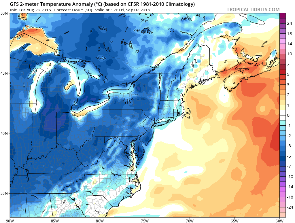
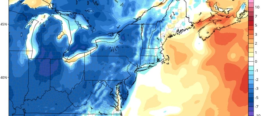
This is a nice shot of cooler than normal air that is moving in as shown by the GFS model. It might be a shade overdone but it will mean for pleasant weather conditions Thursday through at least Saturday.
ROUGH SURF STATEMENTS FOR NEW JERSEY & LONG ISLAND
O.EXT.KPHI.BH.S.0001.000000T0000Z-160901T0000Z/
DELAWARE BEACHES-EASTERN MONMOUTH-ATLANTIC COASTAL CAPE MAY-
COASTAL ATLANTIC-COASTAL OCEAN-
253 PM EDT MON AUG 29 2016

...BEACH HAZARDS STATEMENT NOW IN EFFECT THROUGH WEDNESDAY
EVENING...

THE NATIONAL WEATHER SERVICE IN MOUNT HOLLY HAS ISSUED A BEACH
HAZARDS STATEMENT...WHICH IS IN EFFECT THROUGH WEDNESDAY EVENING.

IF GOING TO THE SHORE OR AREA BEACHES TUESDAY OR WEDNESDAY...BE
ALERT FOR DANGEROUS RIP CURRENTS AND SWIM ONLY IN DESIGNATED AREAS
PATROLLED BY LIFEGUARDS.

SWELLS FROM TROPICAL SYSTEMS HAVE ARRIVED AND SHOULD CONTINUE TO
BUILD TUESDAY INTO WEDNESDAY. THE BREAKERS IN THE BEACH SWIMMING
ZONE WILL LIKELY BE LARGER. THIS WILL INCREASE THE RISK FOR
DANGEROUS RIP CURRENTS AND CAN ALSO KNOCK SWIMMERS AND WADERS INTO
THE SAND.

SWIM ONLY IN DESIGNATED AREAS WATCHED BY LIFEGUARDS. SWIMMING
AFTER THE LIFEGUARDS GO HOME...AND WHERE LIFEGUARDS DO NOT HAVE
YOU IN SIGHT...RAISES THE RISK OF INJURY OR DEATH DUE TO RIP
CURRENTS.

PRECAUTIONARY/PREPAREDNESS ACTIONS...

A BEACH HAZARDS STATEMENT IS ISSUED WHEN THREATS SUCH AS RIP
CURRENTS...LONGSHORE CURRENTS...SNEAKER WAVES AND OTHER HAZARDS
CREATE LIFE-THREATENING CONDITIONS IN THE SURF ZONE. CAUTION
SHOULD BE USED WHEN IN OR NEAR THE WATER.
KINGS (BROOKLYN)-SOUTHWESTERN SUFFOLK-SOUTHEASTERN SUFFOLK-
SOUTHERN QUEENS-SOUTHERN NASSAU-
411 PM EDT MON AUG 29 2016

...HIGH RIP CURRENT RISK NOW IN EFFECT THROUGH TUESDAY EVENING...

* LOCATIONS...THE OCEAN BEACHES OF KINGS...SOUTHERN
  QUEENS...SOUTHERN NASSAU...AND SOUTHERN SUFFOLK COUNTIES.

* RIP CURRENT RISK...HIGH

* SURF HEIGHT...3 TO 4 FEET.

* LIGHTNING RISK...NONE

* TIMING...THROUGH 800 PM EDT TUESDAY.

PRECAUTIONARY/PREPAREDNESS ACTIONS...

RIP CURRENTS ARE POWERFUL CHANNELS OF WATER FLOWING QUICKLY AWAY
FROM SHORE...WHICH OCCUR MOST OFTEN AT LOW SPOTS OR BREAKS IN THE
SANDBAR AND IN THE VICINITY OF STRUCTURES SUCH AS GROINS...
JETTIES AND PIERS. TALK TO LIFEGUARDS AND BEACH OFFICIALS TO
LEARN ABOUT ANY SURF HAZARDS AND HEED THEIR ADVICE. PAY ATTENTION
TO FLAGS AND POSTED SIGNS AND SWIM IN LIFE GUARDED AREAS.

IF YOU BECOME CAUGHT IN A RIP CURRENT...YELL FOR HELP. REMAIN
CALM...DO NOT EXHAUST YOURSELF AND STAY AFLOAT WHILE WAITING FOR
HELP. IF YOU HAVE TO SWIM OUT OF A RIP CURRENT...SWIM PARALLEL TO
SHORE. ONCE YOU ARE AWAY FROM THE FORCE OF THE RIP CURRENT...
BEGIN TO SWIM BACK TOWARD THE BEACH. DO NOT ATTEMPT TO SWIM
DIRECTLY AGAINST A RIP CURRENT AS YOU WILL TIRE QUICKLY.

&&

$$
FiOS1 News Weather Forecast For Long Island
FiOS1 News Weather Forecast For New Jersey
FiOS1 News Weather Forecast For Hudson Valley
NATIONAL WEATHER SERVICE SNOW FORECASTS
LATEST JOESTRADAMUS ON THE LONG RANGE
Weather App

Don’t be without Meteorologist Joe Cioffi’s weather app. It is really a meteorologist app because you get my forecasts and my analysis and not some automated computer generated forecast based on the GFS model. This is why your app forecast changes every 6 hours. It is model driven with no human input at all. It gives you an icon, a temperature and no insight whatsoever.
It is a complete weather app to suit your forecast needs. All the weather information you need is right on your phone. Android or I-phone, use it to keep track of all the latest weather information and forecasts. This weather app is also free of advertising so you don’t have to worry about security issues with your device. An accurate forecast and no worries that your device is being compromised.
Use it in conjunction with my website and my facebook and twitter and you have complete weather coverage of all the latest weather and the long range outlook. The website has been redone and upgraded. Its easy to use and everything is archived so you can see how well Joe does or doesn’t do when it comes to forecasts and outlooks.
Just click on the google play button or the apple store button on the sidebar for my app which is on My Weather Concierge. Download the app for free. Subscribe to my forecasts on an ad free environment for just 99 cents a month.
Get my forecasts in the palm of your hand for less than the cost of a cup of Joe!

MENTION JOE CIOFFI AND GET A 5% DISCOUNT


