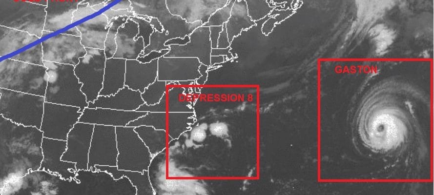
Tropical Depression 8 9 & Gaston
Tropical Storm Forming From Tropical Depression 9
Threat to Florida Coastal Bend
Tropical Storm Warnings May Be Required Later Today


You can see by the satellite loops that the tropical depression near the US are trying to organize. Tropical Depression 9 in the Gulf of Mexico is very close to tropical storm strength this morning. The latest recon from Tropical Depression 8 off North Carolina shows a little better organization this morning and winds are a little higher but still below tropical storm strength. Hurricane Gaston is sitting out in the central Atlantic and rough surf is developing from Maryland to Southern New England.
TROPICAL DEPRESSION NINE ADVISORY NUMBER   7
NWS NATIONAL HURRICANE CENTER MIAMI FL       AL092016
400 AM CDT TUE AUG 30 2016

...DEPRESSION EXPECTED TO STRENGTHEN SOON...


SUMMARY OF 400 AM CDT...0900 UTC...INFORMATION
----------------------------------------------
LOCATION...23.8N 86.6W
ABOUT 305 MI...495 KM W OF KEY WEST FLORIDA
ABOUT 270 MI...435 KM W OF HAVANA CUBA
MAXIMUM SUSTAINED WINDS...35 MPH...55 KM/H
PRESENT MOVEMENT...W OR 275 DEGREES AT 7 MPH...11 KM/H
MINIMUM CENTRAL PRESSURE...1003 MB...29.62 INCHES


WATCHES AND WARNINGS
--------------------
There are no coastal watches or warnings in effect.

Interests in central and northern Florida, and southeastern Georgia
should monitor the progress of this system.


DISCUSSION AND 48-HOUR OUTLOOK
------------------------------
At 400 AM CDT (0900 UTC), the center of Tropical Depression Nine was
located near latitude 23.8 North, longitude 86.6 West. The
depression is moving toward the west near 7 mph (11 km/h).  A slow
west-northwestward motion is expected today.  A turn toward the
north-northwest is expected tonight, followed by a turn toward the
north-northeast on Wednesday.  On the forecast track, the center of
the depression will continue to move slowly away from western Cuba,
and move into the eastern Gulf of Mexico over the next 48 hours.

Reports from a NOAA Hurricane Hunter aircraft indicate that the
maximum sustained winds are near 35 mph (55 km/h) with higher gusts.
Some strengthening is forecast during the next 48 hours, and the
depression is expected to become a tropical storm today.

The estimated minimum central pressure is 1003 mb (29.62 inches)
based on dropsonde data from the NASA Global Hawk aircraft.


HAZARDS AFFECTING LAND
----------------------
RAINFALL:  The depression is expected to produce additional rain
accumulations of 2 to 4 inches over western Cuba through Wednesday,
with maximum storm total amounts up to 12 inches.  These rains
could cause life-threatening flash floods and mud slides.  Storm
total rainfall amounts of 5 to 10 inches are possible over much of
the Florida peninsula through Friday morning, with isolated maximum
amounts of 15 inches possible.  This rainfall may cause flooding
and flash flooding.
TROPICAL DEPRESSION EIGHT INTERMEDIATE ADVISORY NUMBER   8A
NWS NATIONAL HURRICANE CENTER MIAMI FL       AL082016
800 AM EDT TUE AUG 30 2016

...DEPRESSION TURNS NORTH-NORTHWESTWARD...


SUMMARY OF 800 AM EDT...1200 UTC...INFORMATION
----------------------------------------------
LOCATION...34.1N 75.1W
ABOUT 85 MI...135 KM SSE OF CAPE HATTERAS NORTH CAROLINA
MAXIMUM SUSTAINED WINDS...35 MPH...55 KM/H
PRESENT MOVEMENT...NNW OR 345 DEGREES AT 5 MPH...8 KM/H
MINIMUM CENTRAL PRESSURE...1011 MB...29.86 INCHES


WATCHES AND WARNINGS
--------------------
CHANGES WITH THIS ADVISORY:

None.

SUMMARY OF WATCHES AND WARNINGS IN EFFECT:

A Tropical Storm Warning is in effect for...
* The coast of North Carolina from Cape Lookout to Oregon Inlet
* Pamlico Sound

A Tropical Storm Warning means that tropical storm conditions are
expected somewhere within the warning area, in this case within 24
hours.

Interests elsewhere along the Outer Banks of North Carolina should
monitor the progress of the depression.  Additional watches or
warnings may be required later today.

For storm information specific to your area, including possible
inland watches and warnings, please monitor products issued by your
local National Weather Service forecast office.


DISCUSSION AND 48-HOUR OUTLOOK
------------------------------
At 800 AM EDT (1200 UTC), the center of Tropical Depression Eight
was located near latitude 34.1 North, longitude 75.1 West. The
depression is moving toward the north-northwest near 5 mph (8 km/h).
A turn toward the north is expected later today, and a turn toward
the northeast is forecast on Wednesday.  On the forecast track, the
center of the depression will be near the Outer Banks of North
Carolina this afternoon or this evening.

Maximum sustained winds are near 35 mph (55 km/h) with higher
gusts. Slow strengthening is forecast during the next 48 hours, and
the depression could become a tropical storm later today.

The minimum central pressure from Air Force Reserve Hurricane
Hunter aircraft data is 1011 mb (29.86 inches).


HAZARDS AFFECTING LAND
----------------------
WIND:  Tropical storm conditions are expected within the warning
area, beginning by this afternoon.

RAINFALL:  The depression is expected to produce total rain
accumulations of 1 to 3 inches with isolated maximum amounts of 5
inches over far eastern North Carolina, including the Outer Banks
NATIONAL WEATHER SERVICE SNOW FORECASTS
LATEST JOESTRADAMUS ON THE LONG RANGE
Weather App

Don’t be without Meteorologist Joe Cioffi’s weather app. It is really a meteorologist app because you get my forecasts and my analysis and not some automated computer generated forecast based on the GFS model. This is why your app forecast changes every 6 hours. It is model driven with no human input at all. It gives you an icon, a temperature and no insight whatsoever.
It is a complete weather app to suit your forecast needs. All the weather information you need is right on your phone. Android or I-phone, use it to keep track of all the latest weather information and forecasts. This weather app is also free of advertising so you don’t have to worry about security issues with your device. An accurate forecast and no worries that your device is being compromised.
Use it in conjunction with my website and my facebook and twitter and you have complete weather coverage of all the latest weather and the long range outlook. The website has been redone and upgraded. Its easy to use and everything is archived so you can see how well Joe does or doesn’t do when it comes to forecasts and outlooks.
Just click on the google play button or the apple store button on the sidebar for my app which is on My Weather Concierge. Download the app for free. Subscribe to my forecasts on an ad free environment for just 99 cents a month.
Get my forecasts in the palm of your hand for less than the cost of a cup of Joe!
![]()
![]()