Tropical Storm Warning New Jersey to Long Island
Tropical Storm Warning New Jersey to Long Island
Tropical Storm Warnings are now extended eastward to include Long Island Conneticut New York City Southern Westchester and Northeast New Jersey. Tropical Storm Warnings run up the coast from Delaware to Southern New England. Tropical Storm Hermine is strengthening with top winds 65 mph and now has become post tropical.


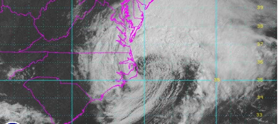
...HERMINE STRENGTHENS AS IT MOVES INTO THE ATLANTIC...
...DANGEROUS STORM SURGE EXPECTED ALONG THE COAST FROM VIRGINIA
TO NEW JERSEY...


SUMMARY OF 1100 AM EDT...1500 UTC...INFORMATION
-----------------------------------------------
LOCATION...36.1N 75.2W
ABOUT 35 MI...55 KM ESE OF DUCK NORTH CAROLINA
ABOUT 80 MI...135 KM SE OF NORFOLK VIRGINIA
MAXIMUM SUSTAINED WINDS...65 MPH...100 KM/H
PRESENT MOVEMENT...ENE OR 60 DEGREES AT 15 MPH...24 KM/H
MINIMUM CENTRAL PRESSURE...993 MB...29.33 INCHES


WATCHES AND WARNINGS
--------------------
CHANGES WITH THIS ADVISORY:

The Tropical Storm Warning has been extended northward and eastward
from Sandy Hook, New Jersey, to west of Watch Hill, Rhode Island,
including Long Island, Long Island Sound, and New York City.

A Tropical Storm Watch has been issued from Watch Hill, Rhode
Island, to Sagamore Beach, Massachusetts, including Block Island,
Martha's Vineyard, Nantucket, and Cape Cod.

SUMMARY OF WATCHES AND WARNINGS IN EFFECT:

A Tropical Storm Warning is in effect for...
* Ocracoke Inlet to west of Watch Hill
* Pamlico and Albemarle Sounds
* Chesapeake Bay from Drum Point southward
* Tidal Potomac from Cobb Island eastward
* Delaware Bay

A Tropical Storm Watch is in effect for...
* Watch Hill to Sagamore Beach
* Block Island
* Martha's Vineyard
* Nantucket

A Tropical Storm Warning means that tropical storm conditions are
expected somewhere within the warning area within 36 hours.

A Tropical Storm Watch means that tropical storm conditions are
possible within the watch area, in this case within 36 to 48 hours.

For storm information specific to your area, including possible
inland watches and warnings, please monitor products issued by your
local National Weather Service forecast office.


DISCUSSION AND 48-HOUR OUTLOOK
------------------------------
Satellite imagery indicates that Hermine has lost tropical
characteristics, and is now a post-tropical cyclone.  At 1100 AM EDT
(1500 UTC), the center of Post-Tropical Cyclone Hermine was located
just offshore of the North Carolina Outer Banks near latitude 36.1
North, longitude 75.2 West.  Hermine is moving toward the east-
northeast near 15 mph (24 km/h).  A turn toward the northeast and a
decrease in forward speed are expected by tonight, followed by a
slow northward motion through early Monday. On the forecast track,
the center of Hermine will move away from the North Carolina coast
and meander offshore of the Delmarva Peninsula Sunday night and
early Monday.

Maximum sustained winds are near 65 mph (100 km/h) with higher
gusts.  Some strengthening is forecast during the next 24 hours,
and Hermine is expected to be near hurricane intensity on Sunday.

Tropical-storm-force winds extend outward up to 205 miles (335 km)
from the center.  A National Ocean Service station at the Duck Pier
in North Carolina recently reported a sustained wind of 58 mph (94
km/h) and a wind gust of 73 mph (117 km/h).  Elizabeth City, North
Carolina, recently reported a sustained wind of 44 mph (70 km/h) and
a wind gust of 55 mph (89 km/h).

The estimated minimum central pressure is 993 mb (29.33 inches).
HERE IS THE LATEST ON THE NAM MODEL WHICH SHIFTED LEFT AGAIN TODAY
FiOS1 News Weather Forecast For Long Island
FiOS1 News Weather Forecast For New Jersey
FiOS1 News Weather Forecast For Hudson Valley
NATIONAL WEATHER SERVICE SNOW FORECASTS
LATEST JOESTRADAMUS ON THE LONG RANGE
Weather App

Don’t be without Meteorologist Joe Cioffi’s weather app. It is really a meteorologist app because you get my forecasts and my analysis and not some automated computer generated forecast based on the GFS model. This is why your app forecast changes every 6 hours. It is model driven with no human input at all. It gives you an icon, a temperature and no insight whatsoever.
It is a complete weather app to suit your forecast needs. All the weather information you need is right on your phone. Android or I-phone, use it to keep track of all the latest weather information and forecasts. This weather app is also free of advertising so you don’t have to worry about security issues with your device. An accurate forecast and no worries that your device is being compromised.
Use it in conjunction with my website and my facebook and twitter and you have complete weather coverage of all the latest weather and the long range outlook. The website has been redone and upgraded. Its easy to use and everything is archived so you can see how well Joe does or doesn’t do when it comes to forecasts and outlooks.
Just click on the google play button or the apple store button on the sidebar for my app which is on My Weather Concierge. Download the app for free. Subscribe to my forecasts on an ad free environment for just 99 cents a month.
Get my forecasts in the palm of your hand for less than the cost of a cup of Joe!
![]()
![]()