TROPICAL STORM HARVEY FORMS TROPICAL STORM WARNINGS POSTED
TROPICAL STORM HARVEY FORMS
TROPICAL STORM WARNINGS POSTED
Satelliute loops and Air Force recon reports clearly show that the potential tropical cyclone east of the Northern Windward/Southern Leeward Islands is now Tropical Storm Harvey. Convection continues to increase around the center with an impressive area of thunderstorms on the western side of the circulation. Weather conditions will begin to deteriorate over the islands this evening and tonight as Tropical Storm Harvey continues to move toward the west.

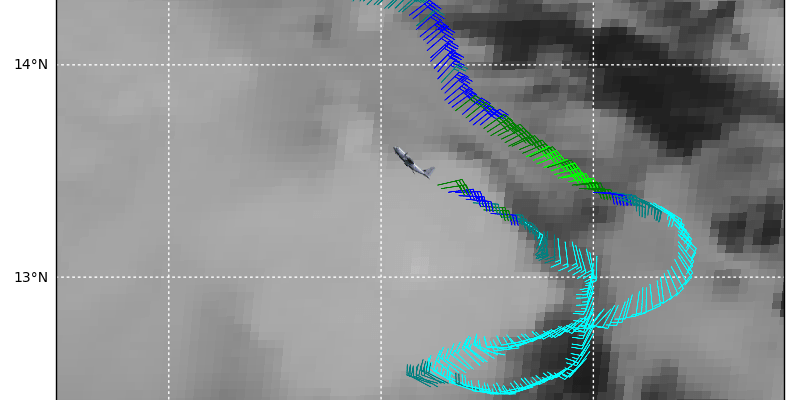
An examination of the wind reports from the aircraft show 40-45 knot flight level winds which would translate to 35-40 knot winds at the surface. The lowest pressure is 1003 millibars which is supportive of tropical storm strength.
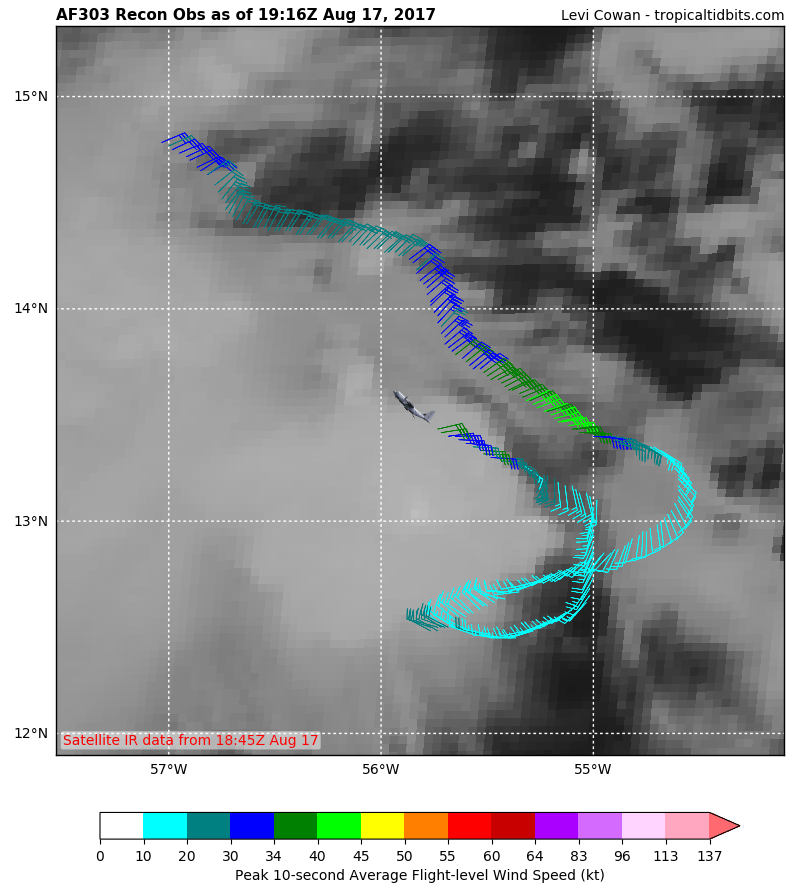
The graphic above is from Tropical Tidbits which is an amazing site for tropical storm coverage. This marks the path of the plane as it flew through the system. The bright green wind barbs are where the plane measured 40-45 knot winds.

…HURRICANE HUNTER FINDS THAT THE DISTURBANCE HAS BECOME
TROPICAL STORM HARVEY…
SUMMARY OF 500 PM AST…2100 UTC…INFORMATION
———————————————-
LOCATION…13.0N 55.8W
ABOUT 250 MI…400 KM E OF BARBADOS
ABOUT 355 MI…570 KM E OF ST. LUCIA
MAXIMUM SUSTAINED WINDS…40 MPH…65 KM/H
PRESENT MOVEMENT…W OR 270 DEGREES AT 18 MPH…30 KM/H
MINIMUM CENTRAL PRESSURE…1004 MB…29.65 INCHES
WATCHES AND WARNINGS
——————–
CHANGES WITH THIS ADVISORY:
None.
SUMMARY OF WATCHES AND WARNINGS IN EFFECT:
A Tropical Storm Warning is in effect for…
* Martinique
* St. Lucia
* Barbados
* St. Vincent and the Grenadines
A Tropical Storm Watch is in effect for…
* Dominica
A Tropical Storm Warning means that tropical storm conditions are
expected somewhere within the warning area, in this case within
24-36 hours.
A Tropical Storm Watch means that tropical storm conditions are
possible within the watch area, in this case within 24-36 hours.
For storm information specific to your area, please monitor
products issued by your national meteorological service.
DISCUSSION AND 48-HOUR OUTLOOK
——————————
At 500 PM AST (2100 UTC), the center of Tropical Storm Harvey was
located near latitude 13.0 North, longitude 55.8 West. Harvey is
moving toward the west near 18 mph (30 km/h), and this motion is
expected to continue for the next couple of days. On the forecast
track, Harvey should move through the Windward Islands and into the
eastern Caribbean Sea on Friday.
Reports from an Air Force Reserve Hurricane Hunter Aircraft indicate
that maximum sustained winds are near 40 mph (65 km/h) with higher
gusts. Slow strengthening is possible during the next 48 hours.
Tropical-storm-force winds extend outward up to 35 miles (55 km)
to the north of the center.
The minimum central pressure estimated from the Hurricane Hunter
data is 1004 mb (29.65 inches).
HAZARDS AFFECTING LAND
———————-
WIND: Tropical storm conditions are expected to first reach the
Lesser Antilles within the warning area by early Friday, making
outside preparations difficult or dangerous. Tropical storm
conditions are possible in the watch area on Friday.
RAINFALL: Harvey is expected to produce rainfall totals of
2 to 4 inches across portions of the Windward Islands from
Martinique southward to Grenada. These rains could cause
life-threatening flash floods and mudslides.

The water vapor loop shows a strong upper low over the Bahamas that is moving westward at about the same speed as Tropical Storm Harvey. This could set up ideal conditions for strengthening once this system reaches the Central Caribbean in about two days. It will be interesting to see what happens to this system since the global weather models which did a horrible job with Hurricane Gert, really don’t do much with this system at all. Track models suggest a track to the west or north of due west similar to the track of Hurricane Franklin.
MANY THANKS TO TROPICAL TIDBITS FOR THE WONDERFUL USE OF THE MAPS
Weather App

Don’t be without Meteorologist Joe Cioffi’s weather app. It is really a meteorologist app because you get my forecasts and my analysis and not some automated computer generated forecast based on the GFS model. This is why your app forecast changes every 6 hours. It is model driven with no human input at all. It gives you an icon, a temperature and no insight whatsoever.
It is a complete weather app to suit your forecast needs. All the weather information you need is right on your phone. Android or I-phone, use it to keep track of all the latest weather information and forecasts. This weather app is also free of advertising so you don’t have to worry about security issues with your device. An accurate forecast and no worries that your device is being compromised.
Use it in conjunction with my website and my facebook and twitter and you have complete weather coverage of all the latest weather and the long range outlook. The website has been redone and upgraded. Its easy to use and everything is archived so you can see how well Joe does or doesn’t do when it comes to forecasts and outlooks.
Just click on the google play button or the apple store button on the sidebar for my app which is on My Weather Concierge. Download the app for free. Subscribe to my forecasts on an ad free environment for just 99 cents a month.
Get my forecasts in the palm of your hand for less than the cost of a cup of Joe!