Tropical Storm Gert Could Become A Hurricane Next 2 Days

Tropical Storm Gert Could Become A Hurricane Next 2 Days
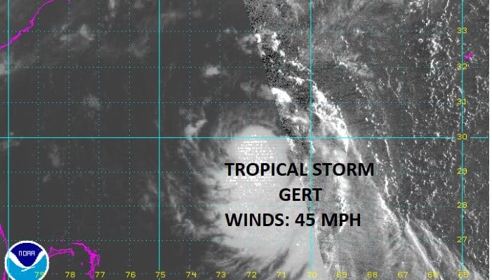
The tropics are beginning to pick up in activity as we have Tropical Storm Gert midway between Florida and Bermuda this morning and you can see on the satellite loop that the outflow continues to expand this morning signalling that the storm continues to organize. Warm water temperatures and a favorable environment for strengthening suggest that Tropical Storm Gert could become a hurricane in the next day or 2 but it will no impact on land as by then it will be moving along to the northeast.

..GERT MOVING NORTH-NORTHWESTWARD OVER THE WESTERN ATLANTIC WELL
AWAY FROM LAND…
SUMMARY OF 500 AM EDT…0900 UTC…INFORMATION
———————————————-
LOCATION…29.7N 72.2W
ABOUT 475 MI…760 KM WSW OF BERMUDA
MAXIMUM SUSTAINED WINDS…45 MPH…75 KM/H
PRESENT MOVEMENT…NNW OR 345 DEGREES AT 9 MPH…15 KM/H
MINIMUM CENTRAL PRESSURE…1009 MB…29.80 INCHES
WATCHES AND WARNINGS
——————–
There are no coastal watches or warnings in effect.
DISCUSSION AND 48-HOUR OUTLOOK
——————————
At 500 AM EDT (0900 UTC), the center of Tropical Storm Gert was
located near latitude 29.7 North, longitude 72.2 West. Gert is
moving toward the north-northwest near 9 mph (15 km/h). A turn
toward the north is forecast to occur later this morning, followed
by a turn toward the north-northeast by tonight. On the forecast
track, Gert is expected to pass about midway between the United
States east coast and Bermuda on Tuesday.
Maximum sustained winds are near 45 mph (75 km/h) with higher gusts.
Some strengthening is forecast during the next 48 hours, and Gert
could become a hurricane by Wednesday.
Tropical-storm-force winds extend outward up to 90 miles (150 km)
from the center.
The estimated minimum central pressure is 1009 mb (29.80 inches).
HAZARDS AFFECTING LAND
———————-
None.
Meanwhile a complex low pressure area in the Eastern Atlantic is evident on the satellite loop as well. It is very broad and pressures across the the tropical Atlantic are abnormally low. The upper air environment is conducive for development and though there is dry air evident on the water vapor loop below, the area seems to be shrinking in scope and not having any immediate impact. Weather models overnight strengthen this system over the next 5 days into a tropical storm as it tracks to the west.

With regards to the solar eclipse next Monday August 21st, here is a look at where we think the best chances are for clear skies. You can read more on this from the latest JOESTADAMUS post.

MANY THANKS TO TROPICAL TIDBITS FOR THE WONDERFUL USE OF THE MAPS
Weather App

Don’t be without Meteorologist Joe Cioffi’s weather app. It is really a meteorologist app because you get my forecasts and my analysis and not some automated computer generated forecast based on the GFS model. This is why your app forecast changes every 6 hours. It is model driven with no human input at all. It gives you an icon, a temperature and no insight whatsoever.
It is a complete weather app to suit your forecast needs. All the weather information you need is right on your phone. Android or I-phone, use it to keep track of all the latest weather information and forecasts. This weather app is also free of advertising so you don’t have to worry about security issues with your device. An accurate forecast and no worries that your device is being compromised.
Use it in conjunction with my website and my facebook and twitter and you have complete weather coverage of all the latest weather and the long range outlook. The website has been redone and upgraded. Its easy to use and everything is archived so you can see how well Joe does or doesn’t do when it comes to forecasts and outlooks.
Just click on the google play button or the apple store button on the sidebar for my app which is on My Weather Concierge. Download the app for free. Subscribe to my forecasts on an ad free environment for just 99 cents a month.
Get my forecasts in the palm of your hand for less than the cost of a cup of Joe!