Solar Eclipse Weather Update Hot Wednesday Ahead
Solar Eclipse Weather Update Hot Wednesday Ahead
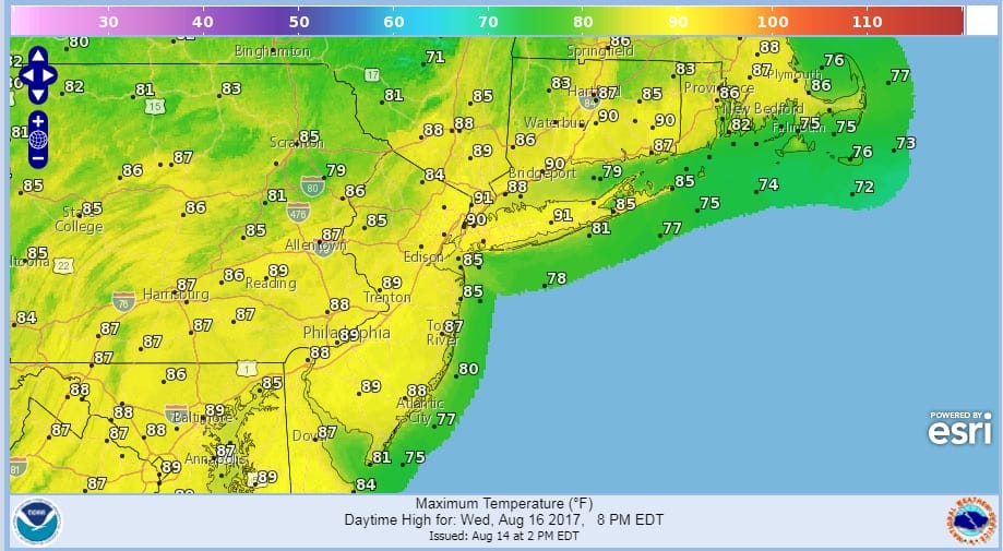
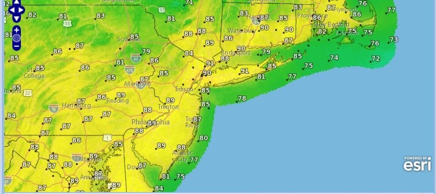
We continue to see a rather uneventful next couple of days though we have some high clouds that have come in as that stalled front to the south remains there and some moisture at high levels is streaming northward. Rain is actually streaming northeastward into South Central Pennsylvania and extends southwestward with rain as far east as Harrisburg. But there is enough dry air for this rain air to basically fall apart as it heads northeast so other than clouds I don’t expect an rain issues overnight. The satellite loop does show another system swinging through the Western Great Lakes and that will move into Northern New England on Tuesday. It will send a weak upper air disturbance swinging around on Tuesday producing a few clouds but not much more. There is the outside chance for a passing shower or downpour. Temperatures tonight will be in the 60s to near 70. Wednesday’s highs will be just into the 80s thanks to clouds. Then Wednesday looks like a hot day with a west northwest wind ahead of another weak disturbance. We should have lots of sunshine with highs up close to 90 in some places.
SATELLITE LOOP

REGIONAL RADAR

LOCAL RADAR NEW YORK CITY

LOCAL RADAR PHILADELPHIA


Thursday looks like a good day with sunshine and highs in the low to mid 80s. Then the next warm front cold front arrives Friday into Saturday and with that there could be the chance for some showers and thunderstorms.
Tropical Storm Gert continues to strengthen this afternoon and it could become a hurricane tonight or Tuesday. While there is no land threat here, there will be coastal offshore issues with rough surf and rip tides developing at the beaches beginning Tuesday and then peaking Wednesday and Thursday.
…GERT GETS A LITTLE STRONGER…
…SWELLS EXPECTED TO BEGIN AFFECTING PORTIONS OF THE U.S. EAST
COAST LATER TODAY…
SUMMARY OF 1100 AM EDT…1500 UTC…INFORMATION
———————————————–
LOCATION…30.3N 72.2W
ABOUT 460 MI…735 KM WSW OF BERMUDA
MAXIMUM SUSTAINED WINDS…60 MPH…95 KM/H
PRESENT MOVEMENT…N OR 360 DEGREES AT 8 MPH…13 KM/H
MINIMUM CENTRAL PRESSURE…1002 MB…29.59 INCHES
WATCHES AND WARNINGS
——————–
There are no coastal watches or warnings in effect.
DISCUSSION AND 48-HOUR OUTLOOK
——————————
At 1100 AM EDT (1500 UTC), the center of Tropical Storm Gert was
located near latitude 30.3 North, longitude 72.2 West. Gert is
moving toward the north near 8 mph (13 km/h). A gradual turn toward
the northeast with an increase in forward speed is forecast for the
next 48 h.
Maximum sustained winds have increased to near 60 mph (95 km/h)
with higher gusts. Additional strengthening is forecast and Gert
is expected to become a hurricane by tomorrow night.
Tropical-storm-force winds extend outward up to 90 miles (150 km)
from the center.
The estimated minimum central pressure is 1002 mb (29.59 inches).
HAZARDS AFFECTING LAND
———————-
SURF: Swells generated by Gert will begin to affect portions
of the coast of North Carolina and Virginia later today. These
swells are likely to cause life-threatening surf and rip current
conditions. Please consult products from your local weather office.
Solar Eclipse Weather
We don’t see any important changes in the Solar Eclipse Weather outlook for our area next Monday August 21. I think there may be some cloud issues for some but latest weather models do seem to have a more optimistic look to them with high pressure building in from the Great Lakes. If this is the case, the chances for clear skies increases for us. Beginning tonight we will be showing the percent of cloud cover graphic for our area and others.
Check the latest JOESTRADAMUS post on the solar eclipse weather from earlier today.
 GET JOE A CIGAR IF YOU LIKE

FiOS1 News Weather Forecast For Long Island
FiOS1 News Weather Forecast For New Jersey
FiOS1 News Weather Forecast For Hudson Valley
NATIONAL WEATHER SERVICE SNOW FORECASTS
LATEST JOESTRADAMUS ON THE LONG RANGE


