Tropical Storm Gert Nears Hurricane Strength
Tropical Storm Gert Nears Hurricane Strength
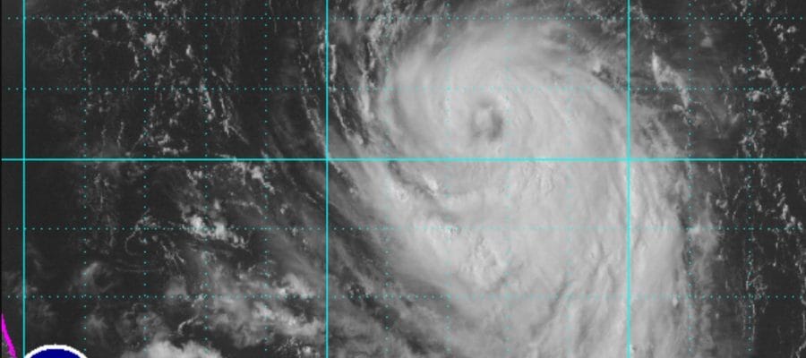
Afternoon satellite pictures show that Tropical Storm Gert may be close to hurricane strength and there is evidence of an eye developing late this afternoon. Tropical Storm Gert is likely to become a hurricane tonight as it continues to track to north and then forecast to turn to the northeast on Tuesday.

..GERT CONTINUES TO STRENGTHEN…
…EXPECTED TO BECOME A HURRICANE TONIGHT…
SUMMARY OF 500 PM EDT…2100 UTC…INFORMATION
———————————————-
LOCATION…30.6N 72.3W
ABOUT 455 MI…735 KM WSW OF BERMUDA
MAXIMUM SUSTAINED WINDS…70 MPH…110 KM/H
PRESENT MOVEMENT…N OR 360 DEGREES AT 8 MPH…13 KM/H
MINIMUM CENTRAL PRESSURE…992 MB…29.30 INCHES
WATCHES AND WARNINGS
——————–
There are no coastal watches or warnings in effect.
DISCUSSION AND 48-HOUR OUTLOOK
——————————
At 500 PM EDT (2100 UTC), the center of Tropical Storm Gert was
located near latitude 30.6 North, longitude 72.3 West. Gert is
moving toward the north near 8 mph (13 km/h). This motion should
continue tonight. A turn toward the northeast with an increase in
forward speed is expected late Tuesday or Tuesday night.
Maximum sustained winds have increased to near 70 mph (110 km/h)
with higher gusts. Additional strengthening is forecast and Gert
is expected to become a hurricane tonight.
Tropical-storm-force winds extend outward up to 105 miles (165 km)
from the center.
The estimated minimum central pressure is 992 mb (29.30 inches).
HAZARDS AFFECTING LAND
———————-
SURF: Swells generated by Gert will spread northward along the
east coast of the United States from North Carolina northward to
Long Island during the next couple of days. Swells are also
expected to affect Bermuda during the next couple of days. These
swells are likely to cause life-threatening surf and rip current
conditions. Please consult products from your local weather office.

Meanwhile in the Tropical Atlantic we have an impressive looking and rather large low pressure system that is moving westward. Conditions are conducive for this system to develop over the next several days and we will continue to monitor this system as it moves to the west.

MANY THANKS TO TROPICAL TIDBITS FOR THE WONDERFUL USE OF THE MAPS
Weather App

Don’t be without Meteorologist Joe Cioffi’s weather app. It is really a meteorologist app because you get my forecasts and my analysis and not some automated computer generated forecast based on the GFS model. This is why your app forecast changes every 6 hours. It is model driven with no human input at all. It gives you an icon, a temperature and no insight whatsoever.
It is a complete weather app to suit your forecast needs. All the weather information you need is right on your phone. Android or I-phone, use it to keep track of all the latest weather information and forecasts. This weather app is also free of advertising so you don’t have to worry about security issues with your device. An accurate forecast and no worries that your device is being compromised.
Use it in conjunction with my website and my facebook and twitter and you have complete weather coverage of all the latest weather and the long range outlook. The website has been redone and upgraded. Its easy to use and everything is archived so you can see how well Joe does or doesn’t do when it comes to forecasts and outlooks.
Just click on the google play button or the apple store button on the sidebar for my app which is on My Weather Concierge. Download the app for free. Subscribe to my forecasts on an ad free environment for just 99 cents a month.
Get my forecasts in the palm of your hand for less than the cost of a cup of Joe!