Tropical Storm Danielle Strenghtens
Should Make Landfall In Mexico Soon

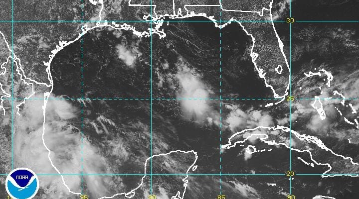
Tropical Storm Danielle strengthens a bit this morning as top winds are now 45 mph. The window of opportunity for strengthening is closing quickly however as the center is making its way toward land and should be making land fall this evening along the Southeast coast of Mexico. Heavy rains and flooding are likely in the mountainous areas to the west.
Tropical Storm Danielle Strenghtens
Western Atlantic Satellite Loop


Tropical Storm Danielle Strenghtens
...DANIELLE MOVING CLOSER TO THE COAST OF MEXICO...
...HEAVY RAINS OCCURRING ACROSS EASTERN MEXICO...


SUMMARY OF 100 PM CDT...1800 UTC...INFORMATION
----------------------------------------------
LOCATION...20.7N 96.6W
ABOUT 55 MI...90 KM ESE OF TUXPAN MEXICO
MAXIMUM SUSTAINED WINDS...45 MPH...75 KM/H
PRESENT MOVEMENT...W OR 275 DEGREES AT 7 MPH...11 KM/H
MINIMUM CENTRAL PRESSURE...1007 MB...29.74 INCHES


WATCHES AND WARNINGS
--------------------
CHANGES WITH THIS ADVISORY:

None.

SUMMARY OF WATCHES AND WARNINGS IN EFFECT:

A Tropical Storm Warning is in effect for...
* Laguna Verde to Rio Panuco Mexico

A Tropical Storm Warning means that tropical storm conditions are
expected somewhere within the warning area.

For storm information specific to your area, please monitor
products issued by your national meteorological service.


DISCUSSION AND 48-HOUR OUTLOOK
------------------------------
At 100 PM CDT (1800 UTC), the center of Tropical Storm Danielle was
located near latitude 20.7 North, longitude 96.6 West. Danielle is
moving toward the west near 7 mph (11 km/h). A motion toward the
west or west-northwest is expected during the next day or so. On
the forecast track, the center of Danielle is expected to move
inland over eastern Mexico later today or tonight.

Maximum sustained winds are near 45 mph (75 km/h) with higher gusts.
Little change in strength is expected before Danielle makes landfall
in Mexico later today.

Tropical-storm-force winds extend outward up to 80 miles (130 km)
from the center.

The estimated minimum central pressure is 1007 mb (29.74 inches).
JOESTRADAMUS HURRICANE SEASON GUEST FORECAST
FiOS1 News Weather Forecast For Long Island
FiOS1 News Weather Forecast For New Jersey
FiOS1 News Weather Forecast For Hudson Valley
NATIONAL WEATHER SERVICE SNOW FORECASTS
LATEST JOESTRADAMUS ON THE LONG RANGE
Weather App

Don’t be without Meteorologist Joe Cioffi’s weather app. It is really a meteorologist app because you get my forecasts and my analysis and not some automated computer generated forecast based on the GFS model. This is why your app forecast changes every 6 hours. It is model driven with no human input at all. It gives you an icon, a temperature and no insight whatsoever.
It is a complete weather app to suit your forecast needs. All the weather information you need is right on your phone. Android or I-phone, use it to keep track of all the latest weather information and forecasts. This weather app is also free of advertising so you don’t have to worry about security issues with your device. An accurate forecast and no worries that your device is being compromised.
Use it in conjunction with my website and my facebook and twitter and you have complete weather coverage of all the latest weather and the long range outlook. The website has been redone and upgraded. Its easy to use and everything is archived so you can see how well Joe does or doesn’t do when it comes to forecasts and outlooks.
Just click on the google play button or the apple store button on the sidebar for my app which is on My Weather Concierge. Download the app for free. Subscribe to my forecasts on an ad free environment for just 99 cents a month.
Get my forecasts in the palm of your hand for less than the cost of a cup of Joe!
![]()