Tropical Storm Danielle

Tropical Storm Danielle Forms SW Gulf Of Mexico

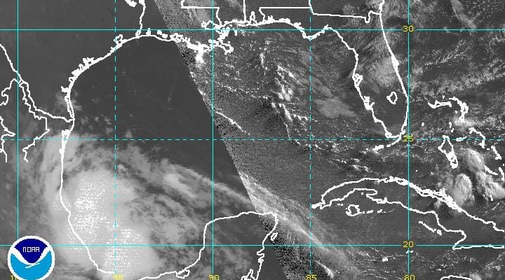
This morning Tropical Depression 4 has seen a rather explosive amount of convection develop around the circulation center. This and reports from an Air Force plane indicate that we have the seasons 4th tropical storm. Tropical Storm Danielle is moving to the west and will move inland at some point later today. There is still a window of opportunity for Danielle to strengthen further. The main threat for Mexico is heavy rains especially in the mountains. Tropical Storm Danielle is no threat to the United States.
Tropical Storm Danielle Western Atlantic Satellite View


Tropical Storm Danielle Forms SW Gulf Of Mexico
...DEPRESSION STRENGTHENS TO FOURTH TROPICAL STORM OF THE SEASON...
...DANIELLE SPREADING RAINS ACROSS EASTERN MEXICO...


SUMMARY OF 700 AM CDT...1200 UTC...INFORMATION
----------------------------------------------
LOCATION...20.6N 96.0W
ABOUT 95 MI...150 KM ESE OF TUXPAN MEXICO
ABOUT 100 MI...160 KM NNE OF VERACRUZ MEXICO
MAXIMUM SUSTAINED WINDS...40 MPH...65 KM/H
PRESENT MOVEMENT...WNW OR 285 DEGREES AT 7 MPH...11 KM/H
MINIMUM CENTRAL PRESSURE...1008 MB...29.77 INCHES


WATCHES AND WARNINGS
--------------------
CHANGES WITH THIS ADVISORY:

None.

SUMMARY OF WATCHES AND WARNINGS IN EFFECT:

A Tropical Storm Warning is in effect for...
* Laguna Verde to Rio Panuco Mexico

A Tropical Storm Warning means that tropical storm conditions are
expected somewhere within the warning area.

For storm information specific to your area, please monitor
products issued by your national meteorological service.


DISCUSSION AND 48-HOUR OUTLOOK
------------------------------
At 700 AM CDT (1200 UTC), the center of Tropical Storm Danielle was
located near latitude 20.6 North, longitude 96.0 West.  Danielle is
moving toward the west-northwest near 7 mph (11 km/h), and this
general motion is expected to continue over the next day or so.  On
the forecast track, the center of Danielle is expected to move
inland over eastern Mexico later today or tonight.

Recent reports from an Air Force Reserve Unit reconnaissance
aircraft indicate that maximum sustained winds have increased to
near 40 mph (65 km/h) with higher gusts. Some slight strengthening
is forecast before Danielle makes landfall in Mexico later today.

Tropical-storm-force winds extend outward up to 40 miles (65 km)
from the center.

The minimum central pressure recently measured by the reconnaissance
aircraft was 1008 mb (29.77 inches).


HAZARDS AFFECTING LAND
----------------------
RAINFALL:  Danielle is expected to produce total rainfall
accumulations of 6 to 10 inches with isolated maximum amounts of
15 inches possible in higher terrain over the Mexican states of
Veracruz, Tamaulipas, San Luis Potosi, Queretaro, Hidalgo, and
northern Puebla.  These rains could cause life-threatening flash
floods and mud slides.

WIND:  Tropical storm conditions are expected to reach the coast
within portions of the warning area later this morning, making
outside preparations difficult or dangerous.

JOESTRADAMUS HURRICANE SEASON GUEST FORECAST
FiOS1 News Weather Forecast For Long Island
FiOS1 News Weather Forecast For New Jersey
FiOS1 News Weather Forecast For Hudson Valley
NATIONAL WEATHER SERVICE SNOW FORECASTS
LATEST JOESTRADAMUS ON THE LONG RANGE
Weather App

Don’t be without Meteorologist Joe Cioffi’s weather app. It is really a meteorologist app because you get my forecasts and my analysis and not some automated computer generated forecast based on the GFS model. This is why your app forecast changes every 6 hours. It is model driven with no human input at all. It gives you an icon, a temperature and no insight whatsoever.
It is a complete weather app to suit your forecast needs. All the weather information you need is right on your phone. Android or I-phone, use it to keep track of all the latest weather information and forecasts. This weather app is also free of advertising so you don’t have to worry about security issues with your device. An accurate forecast and no worries that your device is being compromised.
Use it in conjunction with my website and my facebook and twitter and you have complete weather coverage of all the latest weather and the long range outlook. The website has been redone and upgraded. Its easy to use and everything is archived so you can see how well Joe does or doesn’t do when it comes to forecasts and outlooks.
Just click on the google play button or the apple store button on the sidebar for my app which is on My Weather Concierge. Download the app for free. Subscribe to my forecasts on an ad free environment for just 99 cents a month.
Get my forecasts in the palm of your hand for less than the cost of a cup of Joe!
![]()
![]()

MENTION JOE CIOFFI AND GET A 5% DISCOUNT