Tropical Storm Colin Moving Toward Shore

Tropical Storm Colin Moving Toward Shore
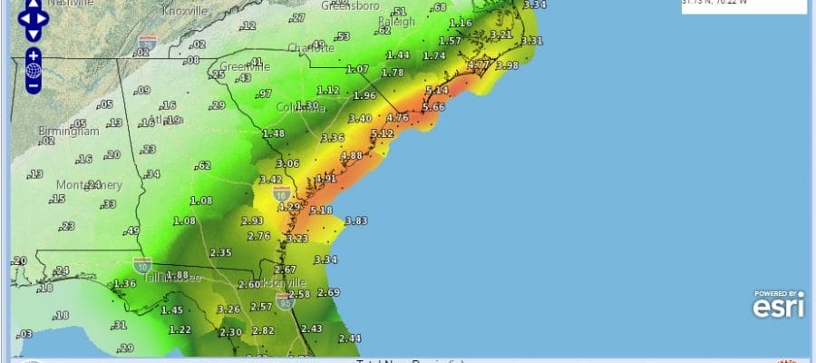
Heavy Rains North Florida Northeast to North Carolina
Tropical Storm Warnings North Florida To The Carolinas

A couple of things over the last few hours have occured. First there seems to be a small burst of convection occuring near the circulation center. The other thing is that clouds on the northern fringe of the moisture shield are over our area now. Notice the vortex in Canada at the same time is dropping southward and swinging to the east. That is the westerly jet dropping south that will eventually take Colin out to sea. I also believe that upper low will energize Colin somewhat once it moves off the South Carolina Coast Tuesday morning. The storm continues to move NNE at over 20 mph.
Tropical Storm Colin Moving Toward Shore Tampa Radar

Tropical Storm Colin Moving Toward Shore Jacksonville Fl. Radar

Heavy rains are continuing to spread northward to the North Carolina coast. During Tuesday the storm will move parallel to the coast and I’m expecting winds will be increasing near the center as pressures fall. Rainfall amounts of 4 to 6 inches are likely in areas that just got big rains from Tropical Storm Bonnie last week!
Tropical Storm Colin Moving Toward Shore Rainfall Forecast

...COLIN NEARING THE BIG BEND AREA OF FLORIDA...


SUMMARY OF 700 PM CDT...0000 UTC...INFORMATION
----------------------------------------------
LOCATION...29.3N 84.7W
ABOUT 35 MI...55 KM SSE OF APALACHICOLA FLORIDA
ABOUT 95 MI...155 KM W OF CEDAR KEY FLORIDA
MAXIMUM SUSTAINED WINDS...50 MPH...85 KM/H
PRESENT MOVEMENT...NE OR 40 DEGREES AT 23 MPH...37 KM/H
MINIMUM CENTRAL PRESSURE...1001 MB...29.62 INCHES


WATCHES AND WARNINGS
--------------------
CHANGES WITH THIS ADVISORY:

None.

SUMMARY OF WATCHES AND WARNINGS IN EFFECT:

A Tropical Storm Warning is in effect for...
* Indian Pass to Englewood
* Sebastian Inlet Florida to Oregon Inlet North Carolina

A Tropical Storm Warning means that tropical storm conditions are
expected somewhere within the warning area.

For storm information specific to your area, including possible
inland watches and warnings, please monitor products issued by your
local National Weather Service forecast office.


DISCUSSION AND 48-HOUR OUTLOOK
------------------------------
At 700 PM CDT (0000 UTC), the center of Tropical Storm Colin was
located near latitude 29.3 North, longitude 84.7 West. Colin is
moving toward the northeast near 23 mph (37 km/h).  A northeastward
motion at a faster forward speed is expected tonight and Tuesday.
On this track, the center of Colin is forecast to move onshore of
the Florida Big Bend area in a few hours, then move across northern
Florida and southeastern Georgia through early Tuesday morning, and
move near or over the southeastern coast of the United States
Tuesday.  However, it's important to note that the strongest winds
and heaviest rains are well removed from the center.

Maximum sustained winds are near 50 mph (85 km/h) with higher gusts.
Some strengthening is forecast on Tuesday and Tuesday night.

Tropical-storm-force winds extend outward up to 230 miles (370 km)
to the southeast of the center.  A WeatherFlow station at
Clearwater Beach Pier recently reported sustained winds of 40 mph
(65 km/h) with a gust to 49 mph (80 km/h).

The estimated minimum central pressure is 1001 mb (29.62 inches).
JOESTRADAMUS HURRICANE SEASON GUEST FORECAST
FiOS1 News Weather Forecast For Long Island
FiOS1 News Weather Forecast For New Jersey
FiOS1 News Weather Forecast For Hudson Valley
NATIONAL WEATHER SERVICE SNOW FORECASTS
LATEST JOESTRADAMUS ON THE LONG RANGE
Weather App

Don’t be without Meteorologist Joe Cioffi’s weather app. It is really a meteorologist app because you get my forecasts and my analysis and not some automated computer generated forecast based on the GFS model. This is why your app forecast changes every 6 hours. It is model driven with no human input at all. It gives you an icon, a temperature and no insight whatsoever.
It is a complete weather app to suit your forecast needs. All the weather information you need is right on your phone. Android or I-phone, use it to keep track of all the latest weather information and forecasts. This weather app is also free of advertising so you don’t have to worry about security issues with your device. An accurate forecast and no worries that your device is being compromised.
Use it in conjunction with my website and my facebook and twitter and you have complete weather coverage of all the latest weather and the long range outlook. The website has been redone and upgraded. Its easy to use and everything is archived so you can see how well Joe does or doesn’t do when it comes to forecasts and outlooks.
Just click on the google play button or the apple store button on the sidebar for my app which is on My Weather Concierge. Download the app for free. Subscribe to my forecasts on an ad free environment for just 99 cents a month.
Get my forecasts in the palm of your hand for less than the cost of a cup of Joe!
![]()
![]()

MENTION JOE CIOFFI AND GET A 5% DISCOUNT