Tropical Storm Cindy Moving Toward Southwest Louisiana
<
Tropical Storm Cindy Moving Toward Southwest Louisiana
PLEASE NOTE THAT THIS VIDEO WAS MADE AT NOON TODAY…THE SYSTEM HAS NOW BEEN UPGRADED TO TROPICAL STORM CINDY
Reports from an Air Force plane as well as satellite and surface observations indicate that the tropical disturbance in the Gulf of Mexico has now reached tropical storm strength. Tropical Storm Cindy has acquired a well defined low level circulation which is what we were waiting for with regards to meeting tropical storm criteria. Most of the convection and the strongest winds continue to be east and northeast of the circulation center.

BULLETIN
Tropical Storm Cindy Intermediate Advisory Number 4A
NWS National Hurricane Center Miami FL AL032017
100 PM CDT Tue Jun 20 2017
…DISTURBANCE BECOMES TROPICAL STORM CINDY…
…HEAVY RAINFALL SPREADING ACROSS MUCH OF THE CENTRAL GULF COAST…
SUMMARY OF 100 PM CDT…1800 UTC…INFORMATION
———————————————-
LOCATION…25.9N 90.5W
ABOUT 265 MI…430 KM S OF MORGAN CITY LOUISIANA
ABOUT 355 MI…565 KM SE OF GALVESTON TEXAS
MAXIMUM SUSTAINED WINDS…45 MPH…75 KM/H
PRESENT MOVEMENT…STATIONARY
MINIMUM CENTRAL PRESSURE…999 MB…29.50 INCHES
WATCHES AND WARNINGS
——————–
CHANGES WITH THIS ADVISORY:
None.
SUMMARY OF WATCHES AND WARNINGS IN EFFECT:
A Tropical Storm Warning is in effect for…
* High Island to the Mouth of the Pearl River
A Tropical Storm Watch is in effect for…
* West of High Island to San Luis Pass
A Tropical Storm Warning means that tropical storm conditions are
expected somewhere within the warning area, in this case within the
next 24 to 36 hours.
A Tropical Storm Watch means that tropical storm conditions are
possible within the watch area, generally within 48 hours.
Interests elsewhere along the U.S. Gulf Coast from the central Texas
coast to the western Florida Panhandle should monitor the progress
of this system.
For storm information specific to your area, including possible
inland watches and warnings, please monitor products issued by your
local National Weather Service forecast office.
DISCUSSION AND 48-HOUR OUTLOOK
——————————
Satellite imagery, aircraft data, and surface observations indicate
that the low pressure system in the central Gulf of Mexico has
acquired a well-defined center, and is now Tropical Storm Cindy, the
third tropical storm of 2017.
At 100 PM CDT (1800 UTC), the center of Tropical Storm Cindy was
centered near latitude 25.9 North, longitude 90.5 West. Cindy has
been stationary for the past few hours, but the system is expected
to resume a motion toward the northwest at around 10 mph (17 km/h)
later today, and this motion is expected to continue through
Wednesday night. A turn toward the north-northwest is forecast early
Thursday. On the forecast track, Cindy is expected to approach
the coast of southwest Louisiana late Wednesday or Wednesday night,
and move inland over western Louisiana and eastern Texas on
Thursday.
Maximum sustained winds are near 45 mph (75 km/h) with higher
gusts. Little change in strength is forecast before the system
reaches the coast on Thursday.
Tropical-storm-force winds extend outward up to 205 miles (335 km),
mainly to the north and east of the center.
The estimated minimum central pressure is 999 mb (29.50 inches).
TROPICAL STORM CINDY MOBILE RADAR

TROPICAL STORM CINDY NEW ORLEANS RADAR

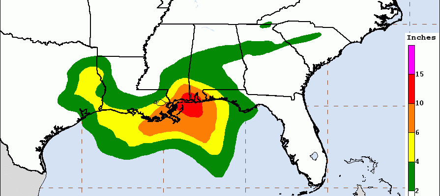
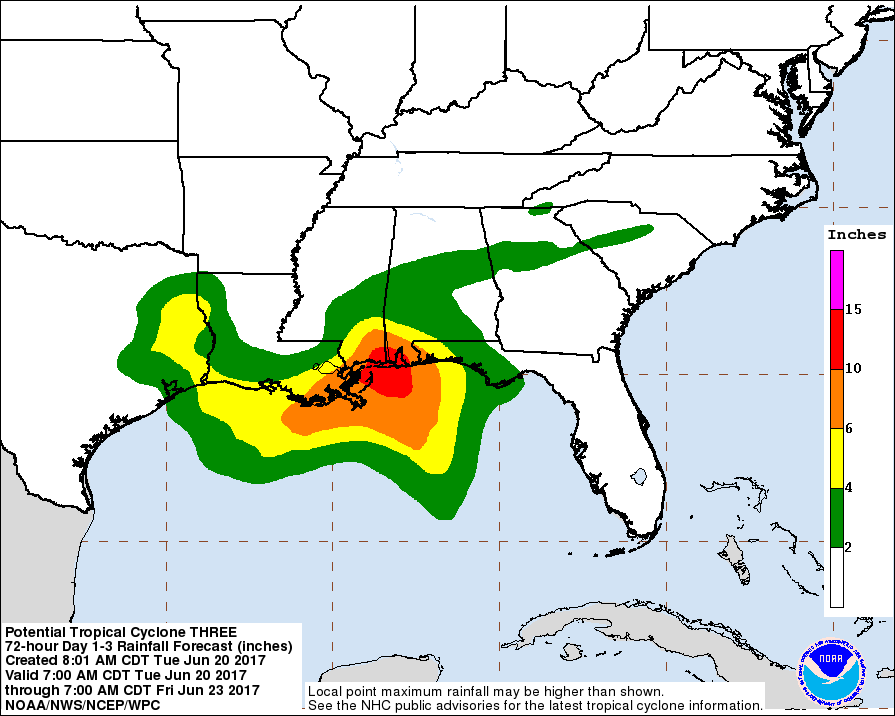
The primary threat from Tropical Storm Cindy will be the heavy rains which radars from Mobile Alabama & New Orleans Louisiana show spreading northwestward. 6 to 12 inches or more of rain is possible over the next two days. There isn’t much going on north and west of the circulation center.
TROPICAL STORM CINDY RAINFALL POTENTIAL
There are questions regarding whether the remnant moisture will move northeastward to the Eastern US late this week or this weekend. We address that issue on the video below.