Tropical Storm Warnings Central Gulf Coast As Cyclone Organizes
Tropical Storm Warnings Central Gulf Coast As Cyclone Organizes
Satellite pictures overnight and this morning continue to show increased organization with the tropical system in the Central Gulf of Mexico. If you look closely at the loop there is a center of circulation and there appears to be an expanding core of thunderstorms on the northeast side near that center. Strong shearing was occuring over the system but this is relaxing somewhat today. That should allow this system to strengthen to a tropical storm later today. Tropical Storm Warnings are posted for much of the Central Gulf Coast from

..DISTURBANCE GRADUALLY BECOMING BETTER ORGANIZED OVER THE CENTRAL
GULF OF MEXICO…
…HEAVY RAINFALL EXPECTED ACROSS PORTIONS OF THE CENTRAL AND
EASTERN GULF COAST…
SUMMARY OF 700 AM CDT…1200 UTC…INFORMATION
———————————————-
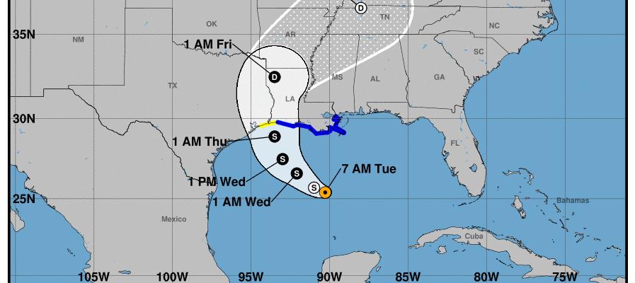
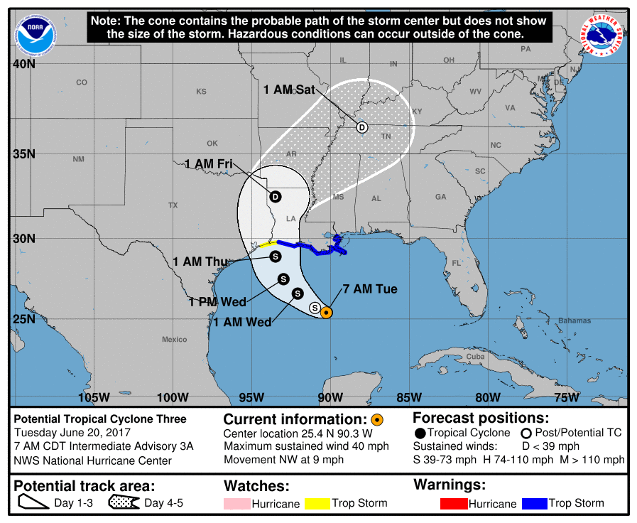
LOCATION…25.4N 90.3W
ABOUT 265 MI…430 KM SSW OF THE MOUTH OF THE MISSISSIPPI RIVER
ABOUT 300 MI…485 KM S OF MORGAN CITY LOUISIANA
MAXIMUM SUSTAINED WINDS…40 MPH…65 KM/H
PRESENT MOVEMENT…NW OR 315 DEGREES AT 9 MPH…15 KM/H
MINIMUM CENTRAL PRESSURE…999 MB…29.50 INCHES
WATCHES AND WARNINGS
——————–
CHANGES WITH THIS ADVISORY:
None.
SUMMARY OF WATCHES AND WARNINGS IN EFFECT:
A Tropical Storm Warning is in effect for…
* Cameron to the Mouth of the Pearl River
A Tropical Storm Watch is in effect for…
* West of Cameron to High Island
A Tropical Storm Warning means that tropical storm conditions are
expected somewhere within the warning area, in this case within the
next 24 to 36 hours.
A Tropical Storm Watch means that tropical storm conditions are
possible within the watch area, generally within 48 hours.
Interests elsewhere along the U.S. Gulf Coast from the central Texas
coast to the western Florida Panhandle should monitor the progress
of this system.
For storm information specific to your area, including possible
inland watches and warnings, please monitor products issued by your
local National Weather Service forecast office.
DISCUSSION AND 48-HOUR OUTLOOK
——————————
At 700 AM CDT (1200 UTC), the disturbance was centered near latitude
25.4 North, longitude 90.3 West. The system is moving toward the
northwest near 9 mph (15 km/h), and this general motion should
continue through Wednesday, with a turn toward the north expected
Wednesday night or Thursday. On the forecast track, the disturbance
is expected to be near the Louisiana coast late Wednesday or
Wednesday night.
Maximum sustained winds are near 40 mph (65 km/h) with higher gusts.
Some slight strengthening is possible before the system reaches the
coast.
Satellite imagery shows that the center of the disturbance is
gradually become better defined, and it is likely that the system
will become a tropical or subtropical cyclone later today.
* Formation chance through 48 hours…high…90 percent
* Formation chance through 5 days…high…90 percent

With respect to the outlook going forward weather models are clustered fairly tightly around a track toward Louisiana or Eastern Texas near the Louisiana border. Afterwards the storm moves inland and the remnanats are forecast to move north and northeastward.
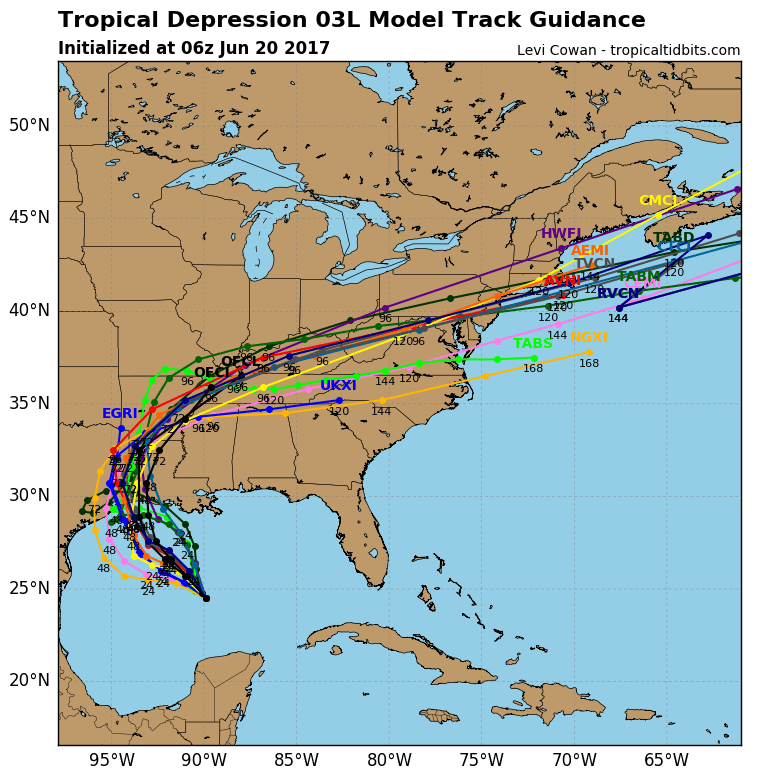
Last night’s global models pretty much show the same idea. This would mean that we run the risk of seeing some rain from this over the weekend. The GFS model last night illustrated this while the European keeps the bulk of the rain to our south.
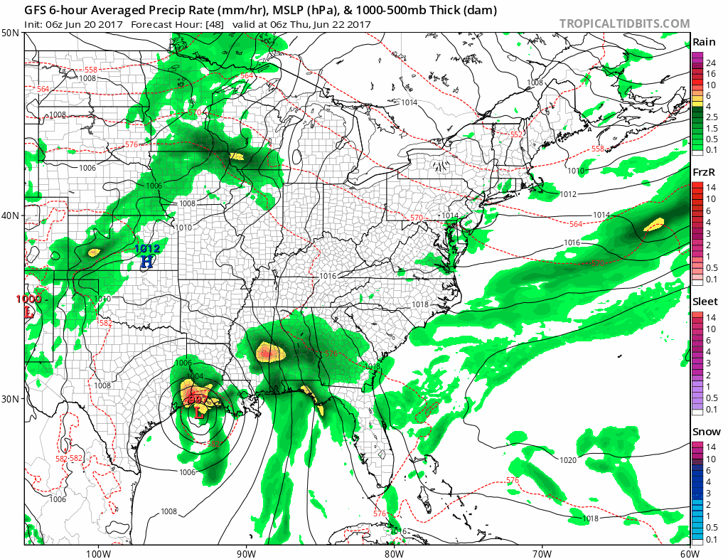
The strength of the ridge and the depth of the next trough will hold the key to how far north this system gets and whether we see rain from it this weekend. If we do see rain in might be on the order of a couple of inches so I don’t think it would anything to extreme. The weather system will be moving along at a decent clip so it will be 8 to 12 hours in and out and done.
JOESTRADAMUS HURRICANE SEASON GUEST FORECAST
FiOS1 News Weather Forecast For Long Island
FiOS1 News Weather Forecast For New Jersey
FiOS1 News Weather Forecast For Hudson Valley
NATIONAL WEATHER SERVICE SNOW FORECASTS
LATEST JOESTRADAMUS ON THE LONG RANGE
Weather App

Don’t be without Meteorologist Joe Cioffi’s weather app. It is really a meteorologist app because you get my forecasts and my analysis and not some automated computer generated forecast based on the GFS model. This is why your app forecast changes every 6 hours. It is model driven with no human input at all. It gives you an icon, a temperature and no insight whatsoever.
It is a complete weather app to suit your forecast needs. All the weather information you need is right on your phone. Android or I-phone, use it to keep track of all the latest weather information and forecasts. This weather app is also free of advertising so you don’t have to worry about security issues with your device. An accurate forecast and no worries that your device is being compromised.
Use it in conjunction with my website and my facebook and twitter and you have complete weather coverage of all the latest weather and the long range outlook. The website has been redone and upgraded. Its easy to use and everything is archived so you can see how well Joe does or doesn’t do when it comes to forecasts and outlooks.
Just click on the google play button or the apple store button on the sidebar for my app which is on My Weather Concierge. Download the app for free. Subscribe to my forecasts on an ad free environment for just 99 cents a month.
Get my forecasts in the palm of your hand for less than the cost of a cup of Joe!
![]()
![]()

MENTION JOE CIOFFI AND GET A 5% DISCOUNT