
Tropical Storm Cindy Heavy Rains 2-3 Inches SE Louisiana
Tropical Storm Cindy Heavy Rains 2-3 Inches SE Louisiana
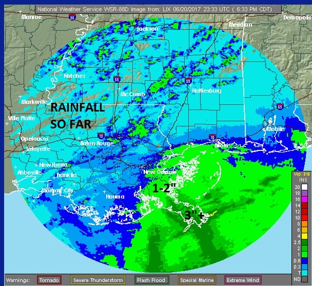
So far rain totals along the immediate coast have already hit 3 inches plus in Southeast Louisiana and we still have quite a way to go when it comes to rainfall here. A large area of 6 to 12 inches of rain is likely from Tropical Storm Cindy when this is all said and done. The satellite loop below sows the circulation center doing what looks like a clockwise loop this evening. The storm remains rather elongated north south with the strongest winds offshore on the northeast side. Not much is happening on the northwest side of the storm though clouds are spreading westward into Texas.

The satellite loop below shows Tropical Storm Cindy and the remnants of Tropical Storm Brett which have degenerated into an open wave in the Southeast Caribbean. Regeneration of Tropical Storm Brett is unlikely given the hostile conditions aloft in the Eastern Caribbean.

Back to Tropical Storm Cindy the radars from Mobile Alabama & New Orleans Louisiana are loaded with rain and heavy rains are moving inland and northwestward. Widespread flooding is likely as rains will continue through Wednesday and probably into Thursday.

..CINDY STILL MEANDERING OVER THE CENTRAL GULF…
…HEAVY RAINFALL COULD PRODUCE LIFE-THREATENING FLASH FLOODING
ACROSS PORTIONS OF THE NORTHERN GULF COAST…
SUMMARY OF 700 PM CDT…0000 UTC…INFORMATION
———————————————-
LOCATION…26.2N 90.3W
ABOUT 250 MI…400 KM SSE OF MORGAN CITY LOUISIANA
ABOUT 350 MI…560 KM SE OF GALVESTON TEXAS
MAXIMUM SUSTAINED WINDS…45 MPH…75 KM/H
PRESENT MOVEMENT…STATIONARY
MINIMUM CENTRAL PRESSURE…997 MB…29.44 INCHES
WATCHES AND WARNINGS
——————–
CHANGES WITH THIS ADVISORY:
None.
SUMMARY OF WATCHES AND WARNINGS IN EFFECT:
A Tropical Storm Warning is in effect for…
* San Luis Pass to the Mouth of the Pearl River
A Tropical Storm Warning means that tropical storm conditions are
expected somewhere within the warning area, in this case within the
next 24 to 36 hours.
Interests elsewhere along the U.S. Gulf Coast from the central Texas
coast to the western Florida Panhandle should monitor the progress
of this system.
For storm information specific to your area, including possible
inland watches and warnings, please monitor products issued by your
local National Weather Service forecast office.
DISCUSSION AND 48-HOUR OUTLOOK
——————————
At 700 PM CDT (0000 UTC), the center of Tropical Storm Cindy was
located near latitude 26.2 North, longitude 90.3 West. Cindy has
been nearly stationary for the past several hours, but a
northwestward motion is expected to resume tonight and continue
through Wednesday. A turn toward the north-northwest and then toward
the north is expected Wednesday night and early Thursday. On the
forecast track, the center of Cindy will approach the coast of
southwest Louisiana and southeast Texas late Wednesday and Wednesday
night, and move inland over southeastern Texas on Thursday.
Maximum sustained winds are near 45 mph (75 km/h) with higher
gusts. Some slight strengthening is expected during the next 24
hours.
Tropical-storm-force winds extend outward up to 205 miles (335 km)
from the center, mainly to the north and east of the center.
The estimated minimum central pressure is 997 mb (29.44 inches).
HAZARDS AFFECTING LAND
———————-
RAINFALL: Cindy is expected to produce total rain accumulations of
6 to 9 inches with isolated maximum amounts of 12 inches over
southeastern Louisiana, southern Mississippi, southern Alabama, and
the Florida Panhandle through Thursday. This rainfall could cause
life-threatening flash flooding in these areas.
Rainfall amounts of 3 to 5 inches with isolated maximum amounts of 6
inches can be expected farther west across southwest Louisiana into
southeast Texas through Thursday.
WIND: Tropical storm conditions are expected to first reach the
coast within the warning area later tonight and spread westward
within the warning area through early Thursday.
STORM SURGE: Inundation of 1 to 3 feet above ground level is
possible along the coast in portions of the Tropical Storm Warning
area.
TORNADOES: Isolated tornadoes are possible this evening and tonight
from south-central Louisiana to the western Florida Panhandle.