Tropical Atlantic Showing Signs of Activity
Tropical Atlantic Showing Signs of Activity
For now as we look at the tropics for the rest of the holiday weekend (through Tuesday) the tropics are quiet. We have skies clear across much of the Gulf of Mexico with nothing going on there.


Wider views of the Western Atlantic & the Tropical Atlantic pretty much show the same story. Weak waves are evident in a few spots but there is nothing here that poses to become a tropical cyclone. However conditions across the Atlantic are going to be changing over the next 5 days. This may create conditions conducive for development.
Looking at the water vapor loop one of the things that has changed across the Central Atlantic are two upper air storms. These storms were producing strong westerly winds across the tropics creating hostile conditions for development. Those upper air storms have moved northeastward and the strong upper air winds across the tropics are beginning to relax.
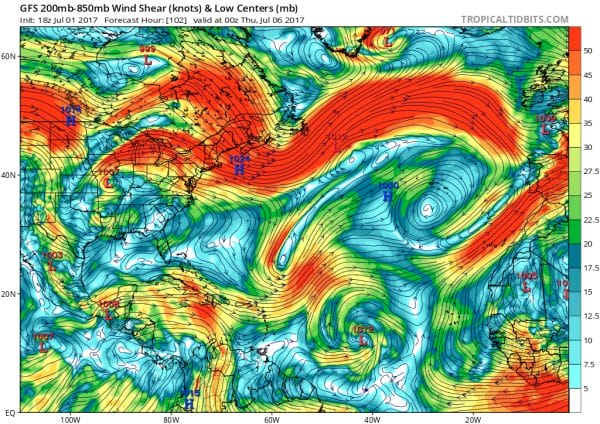
TROPICAL ACTIVITY WIND SHEAR ENVIRONMENT ACROSS THE ATLANTIC
The map above shows wind shear conditions across the Atlantic. Notice near the bottom of the picture a large exapnding area of blue and white. This indicates wind shear conditions in the upper atmosphere. Wind shear looks at wind as we increase with height. Light winds as you go higher in the atmosphere are environments where tropical storms can develop. Strong wind shear environments rip developing tropical systems apart. A wind shear profile like this across the Tropical Atlantic is a condition more favorbale for developemtn.
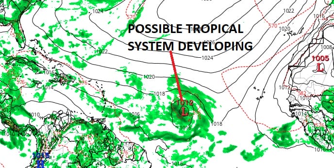
We are also seeing an increase in tropical waves moving off the African coast. Weather models have been keying on one such wave that will be in the Central Tropical Atlantic by the middle of next week.
The GFS model was very good a few weeks ago in showing the development of Tropical Storm Brett which moved into the Southeastern Caribbean & then weakened to a remnant low.The GFS model again is showing a bullsih profile of some sort of system developing and the National Hurricane Center has taken notice in its latest 5 day outlook.
It should be noted that the European & Canadian model show a much weaker surface reflection of this system with neither one showing any kind of developed low at this time. Also to speculate on what this is going to do in the longer term is just ridiculous at this point. It’s like speculating on a snowstorm 10 days out. I have noticed some are already talking this up. Such talk is completely inappropriate at this stage of the game.
JOESTRADAMUS HURRICANE SEASON GUEST FORECAST
FiOS1 News Weather Forecast For Long Island
FiOS1 News Weather Forecast For New Jersey
FiOS1 News Weather Forecast For Hudson Valley
NATIONAL WEATHER SERVICE SNOW FORECASTS
LATEST JOESTRADAMUS ON THE LONG RANGE
Weather App
Don’t be without Meteorologist Joe Cioffi’s weather app. It is really a meteorologist app because you get my forecasts and my analysis and not some automated computer generated forecast based on the GFS model. This is why your app forecast changes every 6 hours. It is model driven with no human input at all. It gives you an icon, a temperature and no insight whatsoever.
It is a complete weather app to suit your forecast needs. All the weather information you need is right on your phone. Android or I-phone, use it to keep track of all the latest weather information and forecasts. This weather app is also free of advertising so you don’t have to worry about security issues with your device. An accurate forecast and no worries that your device is being compromised.
Use it in conjunction with my website and my facebook and twitter and you have complete weather coverage of all the latest weather and the long range outlook. The website has been redone and upgraded. Its easy to use and everything is archived so you can see how well Joe does or doesn’t do when it comes to forecasts and outlooks.
Just click on the google play button or the apple store button on the sidebar for my app which is on My Weather Concierge. Download the app for free. Subscribe to my forecasts on an ad free environment for just 99 cents a month.
Get my forecasts in the palm of your hand for less than the cost of a cup of Joe!
MENTION JOE CIOFFI AND GET A 5% DISCOUNT


