Thunderstorms South Jersey Spreading Northward
Thunderstorms South Jersey Spreading Northward
We continue to see an active radar as new downpours this afternoon have been forming over Southern New Jersey and Southeastern Pennsylvania with an array of warnings being issued. The threat for Flash flooding continues for everywhere from Eastern Pennsylvania to New England. Breaks in the rain have occurred as well. When that happens as the satellite loop shows we just sit in lots of clouds with temperatures mostly in the 70s.
EASTERN SATELLITE

REGIONAL RADAR

The morning heavy rain has moved northward into New England while the regional and local radars will likely remain busy into the first part of tonight. It is likely that activity will drop off overnight.
LOCAL RADAR NEW YORK CITY

LOCAL RADAR PHILADELPHIA


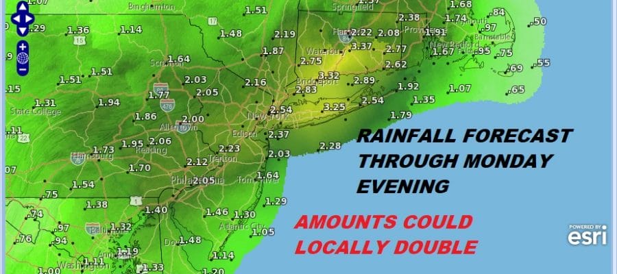
Obviously the threshold for flash flooding is very low with all the rain of this morning and for much of the last 2 weeks. Additional rainfall amounts through Monday evening could total 2 to 3 inches with locally higher amounts probable. Flash Flood Watches continue until further notice.
FLASH FLOOD WATCH IN EFFECT RAINFALL FORECAST THROUGH 9PM MONDAY

Weather models continue to go back and forth on timing which makes using them a bit useless at this stage of the game. The bottom line is the upper trough to the west will continue to fire up heavy downpours through at least Tuesday.

Monday and Tuesday we could see some especially heavy downpours with the upper trough nearby to our west. There should be some rather strong tropical forcing that will result in torrential rains. The question is where and when. I would tend to favor areas north and west of the coast where rainfall has already been excessive. It would be wise to pay attention to radars and forecasts since flooding issues will be front and center.
RAINFALL AMOUNTS REPORTED SO FAR
*******************STORM TOTAL
NEW JERSEY
…Bergen County…
Ridgewood 1.40 1134 AM 8/11 Trained Spotter
Tenafly 1.37 836 AM 8/11 Trained Spotter
…Hudson County…
Harrison 1.59 1042 AM 8/11 Co-Op Observer
NEW YORK
…New York County…
Central Park 2.73 1139 AM 8/11 ASOS
…Suffolk County…
Upton 4.11 1136 AM 8/11 NWS Office
Wading River 2.00 819 AM 8/11 NWS Employee
Southampton 1.10 1028 AM 8/11 Public
**********************24 HOUR RAINFALL**********************
LOCATION 24 HOUR TIME/DATE COMMENTS
RAINFALL OF
/INCHES/ MEASUREMENT
CONNECTICUT
…New Haven County…
1 E Branford 1.56 803 AM 8/11 AWS
1 W Madison 1.01 700 AM 8/11 CoCoRaHS
NEW JERSEY
…Bergen County…
Cresskill 2.24 803 AM 8/11 AWS
Oakland 1.76 803 AM 8/11 AWS
WNW Palisades Park 1.31 930 AM 8/11 CoCoRaHS
North Arlington 1.06 835 AM 8/11 CoCoRaHS
…Essex County…
North Caldwell 1.80 940 AM 8/11 CoCoRaHS
North Caldwell 1.75 815 AM 8/11 CWOP
Caldwell 1.37 753 AM 8/11 ASOS
Maplewood 1.26 900 AM 8/11 CoCoRaHS
2 SE Harrison 1.10 754 AM 8/11 GOES
…Hudson County…
1 NNE Secaucus 2.00 803 AM 8/11 AWS
Hoboken 1.75 817 AM 8/11 CWOP
1 WSW North Arlingto 1.34 818 AM 8/11 CWOP
Jersey City 1.00 800 AM 8/11 NJWXNET
…Union County…
New Providence 1.12 730 AM 8/11 CoCoRaHS
NEW YORK
…Nassau County…
Matinecock 1.20 804 AM 8/11 AWS
…Suffolk County…
Westhampton Airport 2.54 753 AM 8/11 ASOS
Baiting Hollow 2.30 1017 AM 8/11 Co-Op Observer
Remsenburg-Speonk 2.14 700 AM 8/11 CoCoRaHS
1 E Middle Island 2.00 820 AM 8/11 CWOP
1 E East Moriches 1.80 816 AM 8/11 CWOP
1 S Hampton Bays 1.60 817 AM 8/11 CWOP
2 S Brookhaven Natio 1.41 700 AM 8/11 CoCoRaHS
Mastic Beach 1.22 822 AM 8/11 CWOP
…Westchester County…
Armonk 1.65 900 AM 8/11 CoCoRaHS
White Plains Airport 1.10 756 AM 8/11
MANY THANKS TO TROPICAL TIDBITS FOR THE USE OF MAPS
Please note that with regards to any tropical storms or hurricanes, should a storm be threatening, please consult your local National Weather Service office or your local government officials about what action you should be taking to protect life and property.
LATEST JOESTRADAMUS ON THE LONG RANGE


