Downpours Thunderstorms Loom Overnight & Monday
Downpours Thunderstorms Loom Overnight & Monday

We are going to catch a bit of a break today in that there will probably not be any widespread activity like we saw yesterday. Rainfall amounts yesterday were insane over some areas with 4 to 6 inches over parts of Northern New Jersey causing some incredible flooding in some areas including cars getting washed away from a car dealership in Wayne New Jersey. You can see the video on my facebook page. Meanwhile we have lots of clouds. There are some scattered thunderstorms around this morning and there are some isolated pockets of flash flooding. Overall today it will be cloudy with the occasional downpour or thunderstorm with highs into the 80s.
EASTERN SATELLITE

REGIONAL RADAR

All the activity on the radar this morning is to the east as low pressure sits offshore. Not much is on the radar to the west at the moment. However this will likely change tonight and Monday as the next surge of rain develops and rotates northward.
LOCAL RADAR NEW YORK CITY

LOCAL RADAR PHILADELPHIA


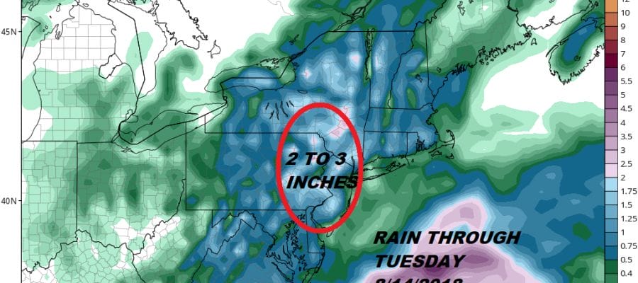
We will see some downpours and thunderstorms on Monday and thiere is risk for another round of Flash Flooding with the ground so saturated. Tuesday could be the last day of widespread activity as this upper trough finally lifts out to the east and weather conditions could improve a bit later next week though the threat for downpours and thunderstorms will be there every day.
MANY THANKS TO TROPICAL TIDBITS FOR THE USE OF MAPS
Please note that with regards to any tropical storms or hurricanes, should a storm be threatening, please consult your local National Weather Service office or your local government officials about what action you should be taking to protect life and property.
LATEST JOESTRADAMUS ON THE LONG RANGE


