
DOWNLOAD MY NEW FREE JOESTRADAMUS WEATHER APP FOR ALL DEVICES
THE APP IS ABSOLUTELY FREE TO ALL BUT CONSIDERING SUBSCRIBING TO PATREON FOR A WEATHER EXPERIENCE FREE OF ADS, EXCLUSIVE VIDEOS FOR MEMBERS ONLY AND MUCH MORE…STARTS AT $2 A MONTH..MESSAGE ME AT ANY TIME
Sunshine On Last Day of Winter Spring Rain Thursday Wind Friday
We can certainly get used to the idea of sunshine. This is the 5th day in a row of decent weather. Even if the fine details haven’t been perfect (either too chilly or too breezy), it is the first time in a long time we have strung 5 days of sun so enjoy it. We have mainly clear skies this morning on the satellite loop. Clouds with low pressure off the Florida coast is moving to the northeast while clouds around the Great Lakes with the next cold front are swinging eastward. Neither of those systems are issues here today so enjoy the sun. Highs will reach the 50s however look for sea breezes to develop along south facing shorelines this afternoon and that takes temperatures back into the 40s over Long Island, Coastal New Jersey and Southern Connecticut.
SATELLITE

REGIONAL RADAR

Look closely along the North Carolina coast you are beginning to see some rain developing on the regional radar. Low pressure will form here and hook up with a cold front to the west. Clouds will increase tonight with temperatures holding mostly in the upper 30s to mid 40s. Rain will begin to move northward Friday morning. Some precipitation runs out ahead around daybreak but the main are of rain will be from late morning until early morning on Friday.
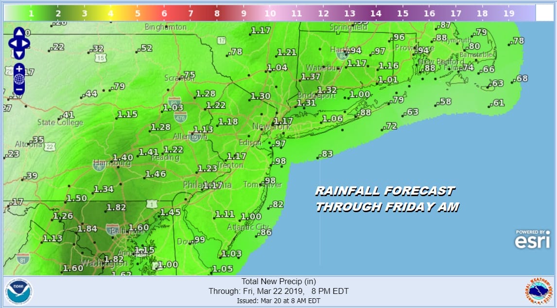
It appears that many areas will get at least an inch of rain out of this. This is not a noreaster. It is a cold front with a wave at the base of the front which strengthens as it heads up into New England. This will drive the weather on Friday with increase winds, variable clouds and a few rain showers or possibly snow showers in some elevated areas. Highs Friday will be in the 40s to near 50.
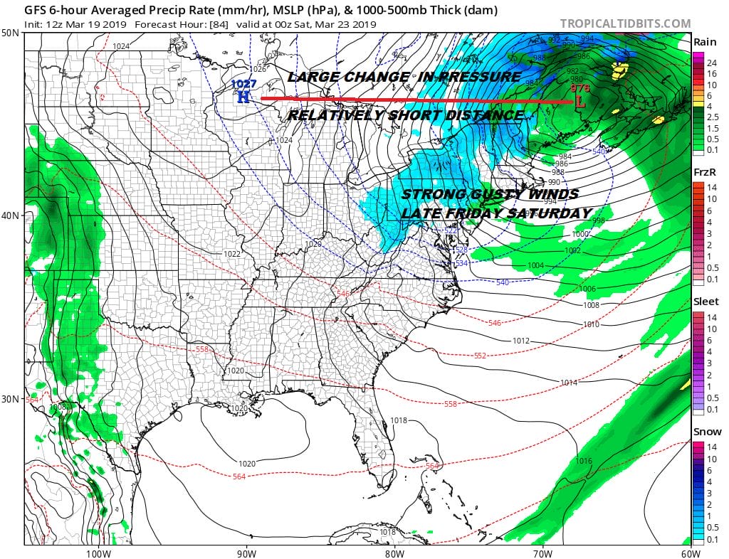 The other issue for Friday will be increasing winds to 20 to 30 mph with gusts into the 40s. This will start to crank up later in the day Friday and the strongest winds will be Friday night into Saturday. Saturday we should see more in the way of sunshine with highs in the upper 40s and lower 50s. The shot of chilly air and the strong winds will ease rapidly Sunday and we should warm up with sunshine Sunday. Highs will reach the mid 50s to some lower 60s.
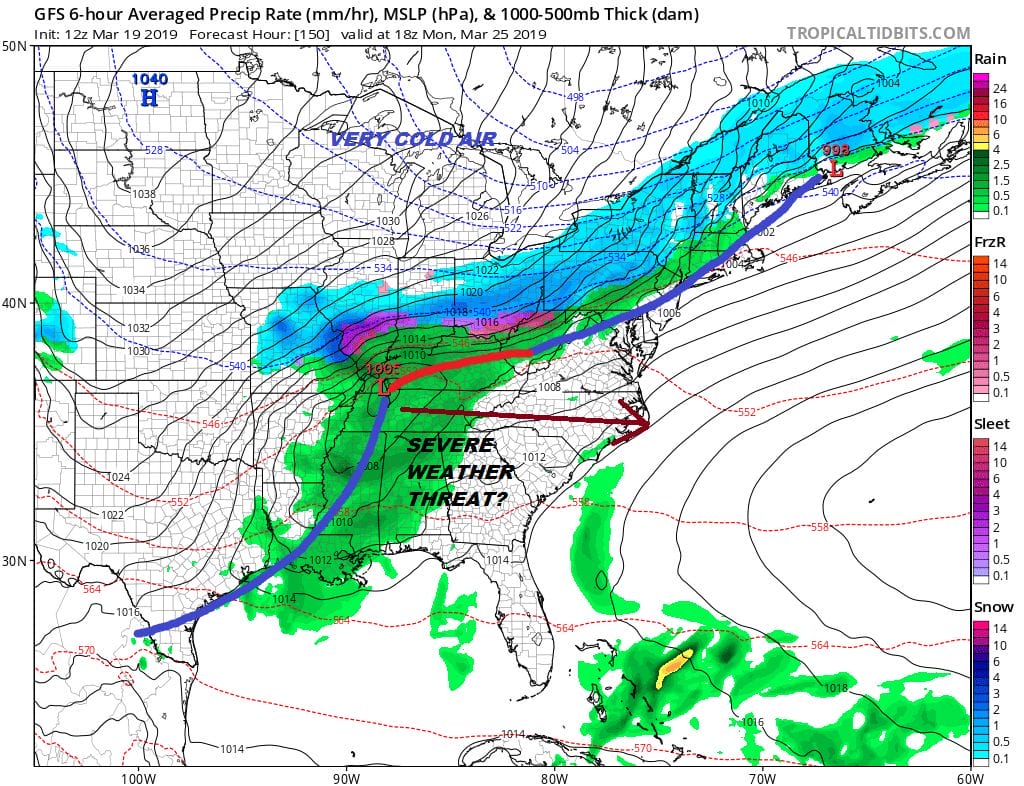
We have a cold front approaching from the northwest on Monday. Look for arriving clouds with highs in the upper 50s to lower 60s. Showers come in later in the day and we could see those showers change to some snow showers Monday night. All of this sinks to the south fairly rapidly and of no real consequence here. Tuesday we will see clouds and some sunshine and it will be cold with highs just in the 40s. No major storms are on the horizon.
MANY THANKS TO TROPICAL TIDBITS FOR THE USE OF MAPS
Please note that with regards to any tropical storms or hurricanes, should a storm be threatening, please consult your local National Weather Service office or your local government officials about what action you should be taking to protect life and property.


