DOWNLOAD MY NEW FREE JOESTRADAMUS WEATHER APP FOR ALL DEVICES
THE APP IS ABSOLUTELY FREE TO ALL BUT CONSIDERING SUBSCRIBING TO PATREON FOR A WEATHER EXPERIENCE FREE OF ADS, EXCLUSIVE VIDEOS FOR MEMBERS ONLY AND MUCH MORE…STARTS AT $2 A MONTH..MESSAGE ME AT ANY TIME
Rain Wind Spring Arrives Dry Weekend
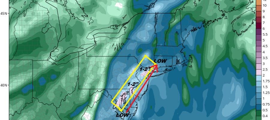
Our beautiful day is coming to a close now and we can see two weather systems taking shape on the satellite loop below. The first is a system now crossing the Great Lakes and Ohio Valley with some showers. The second is a storm that is moving well to the east of the Florida coast however another low is beginning to form along the North Carolina coast. This low will hook up with the Great Lakes system and move northward Thursday and strengthen as it heads into New England. Get ready for some rain to arrive during Thursday morning from south to north and reaching areas from NYC north and east by Thursday afternoon.There could be a few bands of rain that arrive during the early morning hours before daybreak but the main rain will wait for later in the day.
SATELLITE

There are no issues to worry about for this evening and tonight other than arriving clouds later tonight. The regional radar is showing the beginnings of some rain in Eastern North Carolina and Southeast Virginia. It hasn’t developed much during the day but we will see this pick up tonight. Temperatures tonight will settle in the upper 30s and lower 40s and stay in the 40s on Thursday.
REGIONAL RADAR

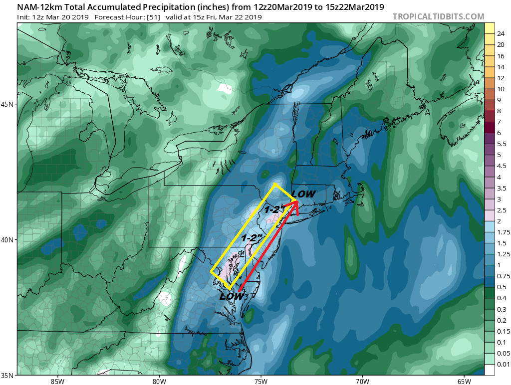
The track of the surface low looks to be right along or just inland of the coast. There will likely be some heavy downpours with this and the heaviest rain will likely fall north and west of the low track. 1 to 2 inches of rain seems likely there. A bit less will fall east of the low track.

The NAM model runs from 11am Thursday through 5am Friday and the low does move right along. Weather conditions will be improving during Friday but as the low strengthens in New England the next issue will be the wind which will start to crank up as the day wears on Friday. There could also be some passing afternoon showers on Friday as the upper air system moves by. We like the NAM’S idea regarding track and the rainfall potential. Temperatures should reach the 50s until the upper trough moves through late in the day and then winds will pick up sharply Friday night and Saturday.
Saturday will be windy with some sunshine and highs in the 50s. Winds will be 20 to 30 mph with some gusts into the 40 mph range. Winds will start to ease Saturday night and turn to the west on Sunday. This means warmer temperatures Sunday with plenty of sunshine and highs reaching into the 60s. Not bad really for a weekend in March and the first weekend of the spring season.
MANY THANKS TO TROPICAL TIDBITS FOR THE USE OF MAPS
Please note that with regards to any tropical storms or hurricanes, should a storm be threatening, please consult your local National Weather Service office or your local government officials about what action you should be taking to protect life and property.


