DOWNLOAD MY NEW FREE JOESTRADAMUS WEATHER APP FOR ALL DEVICES
THE APP IS ABSOLUTELY FREE TO ALL BUT CONSIDERING SUBSCRIBING TO PATREON FOR A WEATHER EXPERIENCE FREE OF ADS, EXCLUSIVE VIDEOS FOR MEMBERS ONLY AND MUCH MORE…STARTS AT $2 A MONTH..MESSAGE ME AT ANY TIME
Spring Arrives Rain Late Thursday Windy Friday Saturday
We continue to enjoy some nice weather here as the weather at the moment is quiet except for rain across Central & Southern Florida. There are no weather issues into early Thursday as skies tonight will be mostly clear and it would be cold overnight with lows in the 20s to lower 30s. High pressure will be moving offshore later Wednesday which will leave us with a nice day with plenty of sunshine. Highs will reach the 50s. There may be some seabreeze action Wednesday afternoon along south facing shorelines which will knock temperatures down in the afternoon.
SATELLITE

REGIONAL RADAR

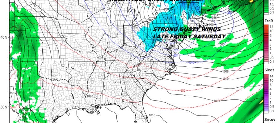
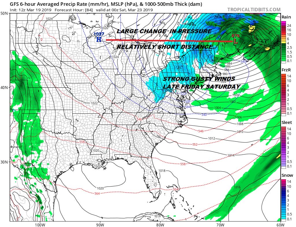
Thursday we will see thickening clouds with a cold front approaching from the west. An offshoot wave from an offshore low will develop near the base of the cold front and move up the East Coast. Rain will likely develop later Thursday morning from south to north and then end sometime during the early morning hours on Friday. This low will be moving right along and strengthening as it heads into New England early Friday morning. We could see some heavy downpours as the low tracks northward.

Rainfall amounts of an inch or so is possible with some higher amounts north and west of the low track. The strengthening low leads to a tightening pressure gradient Friday into Saturday. The rain will be done during the early morning hours Friday but a strong upper trough moving through Friday will create some scattered rain and snow showers as it moves across. Gusty northwest winds will develop thanks to a tightening pressure gradient. Winds should be on the order of 20 to 30 mph with gusts into the 40s late in the day Friday into at least part of Saturday.
The weekend will be dry. Saturday will be windy for awhile with more sunshine though there will be some patchy clouds around with highs reaching the upper 40s and lower 50s. Sunday the winds calm down and we should warm up nicely into the 50s and even some lower 60s are possible. Sunday will see a west wind which will keep local seabreezes out for much of the day.Overall it is a decent dry weekend for the first weekend of spring.
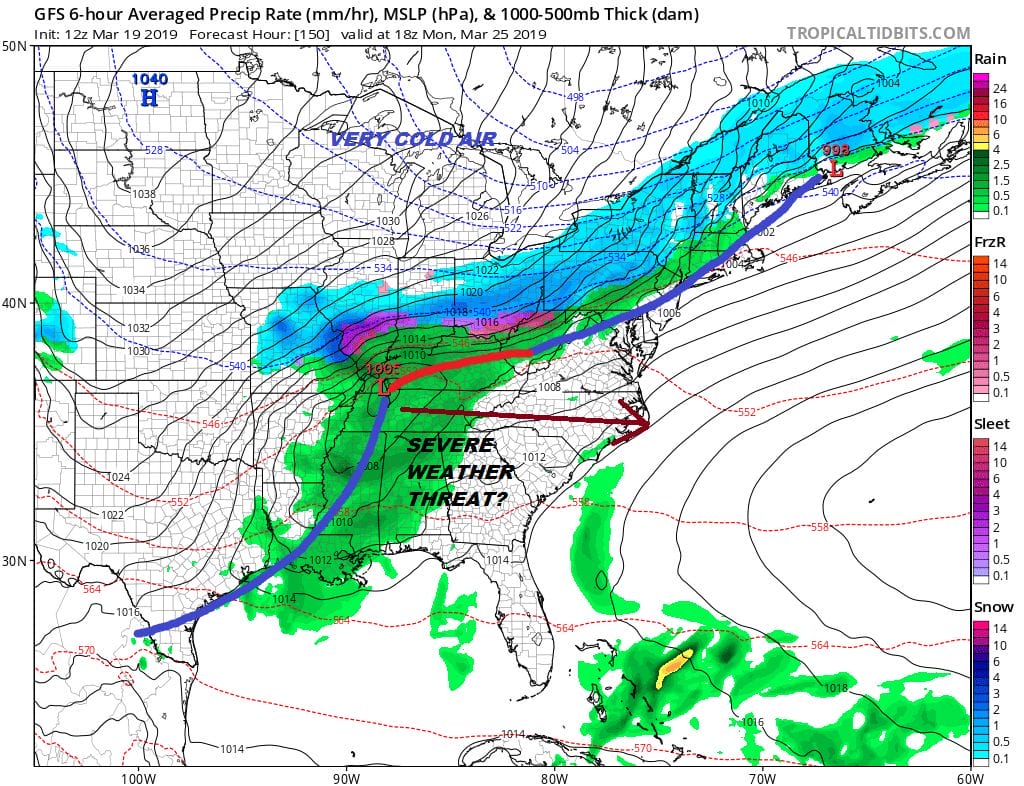
Monday will bring another cold front through here with a big cold high back in the Dakotas. Monday we will reach the 50s and lower 60s before the front passes. Typically the GFS is showing WAY TOO MUCH precipitation behind the front and for now we look for some rain showers that perhaps could change into a few snow showers. The low shown in the Tennessee Valley will likely be suppressed further south thanks to a strong northern jet stream
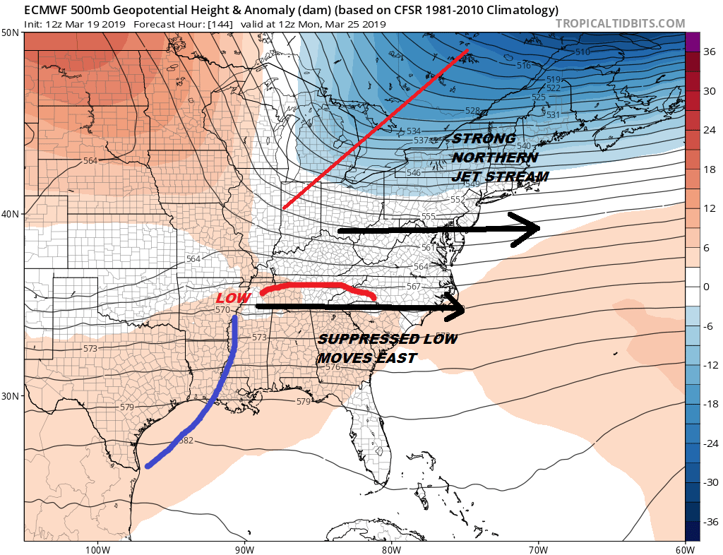
The upper pattern continues to evolve into a typical early spring pattern with shots of cold air lasting a day or two with the northern jet hanging on. There is no blocking so the shots will be transient and not last more than a day or two. It appears that much of next week here will be dry with the exception of whatever happens precipitation wise later Monday as the cold front passes.
MANY THANKS TO TROPICAL TIDBITS FOR THE USE OF MAPS
Please note that with regards to any tropical storms or hurricanes, should a storm be threatening, please consult your local National Weather Service office or your local government officials about what action you should be taking to protect life and property.


