Sunshine Breezy Sunday Cold Air Midweek
SHOP THE JOESTRADAMUS STORE
Sunshine Breezy Sunday Cold Air Midweek
Sunshine Breezy Sunday Cold Air Midweek
If yesterday was any indication of the kind of winter we are going to have than it looks to be a strange and long one. The heaviest snow wound up falling in the Hudson Valley & Eastern Pennsylvania which were supposed to see far less, while areas to the east and south were supposed to get the most get less (though they did get something). From the standpoint of the forecast the area in the middle got a general 2-4/3-5 inch snowfall which was about in line with forecasts. This was certainly a good example of just tough these things are.
Today we are seeing improving weather conditions with some sunshine and a few clouds as a disturbance and upper trough swing through. It will be a bit breezy at times but overall a nice day with highs generally in the upper 30s and lower 40s which should help in some snow melt. Then skies should be partly to mostly clear tonight with lows in the 20s to lower 30s.
SATELLITE LOOP

REGIONAL RADAR

Monday we have the next weather system diving down out of Canada and behind it is a shot of very cold air for the middle of the week. That cold air arrives beginning later Tuesday. Monday looks okay with sunshine and arriving clouds with highs in the upper 30s and lower 40s.
The low center will be passing by to our north which means we will warm up a bit ahead of it and there is the chance for some rain or snow showers with this late Monday night into Tuesday morning. In areas north and west of the coast into NW New Jersey, Northeastern Pennsylvania into the Hudson Valley and Connecticut a quick coating to an inch or so is not impossible as a warm front passes through. Then it will be mild for a little while Tuesday until a cold front passes and then it is windy and much colder. From highs Tuesday in the 40s to near 50 in some warm spots we will head down into the teens and lower 20s by Wednesday morning.
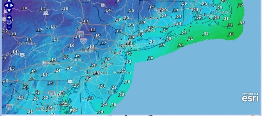
WEDNESDAY MORNING FORECAST LOWS
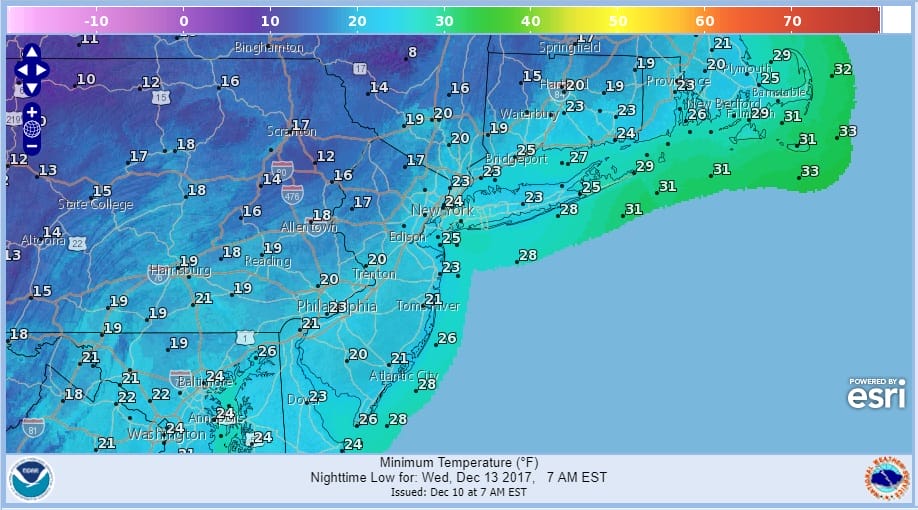
Wednesday will be the coldest day we have experienced snow far with some sunshine but a gusty wind and temperatures not out of the 20s in many areas. This will be followed by another cold night Wednesday night into Thursday morning with lows again in the teens and low 20s. Sunshine Thursday should take us back into the upper 20s and lower 30s. No big storms are on the horizon this week. We do have the Tuesday fast moving system to our north and another one late this week that looks to go by near or just to our south but that appears to be weak at the moment.
 GET JOE A CIGAR IF YOU LIKE

FiOS1 News Weather Forecast For Long Island
FiOS1 News Weather Forecast For New Jersey
FiOS1 News Weather Forecast For Hudson Valley


