Storm Threat Sunday PM-Tuesday Noreaster

Storm Threat Sunday PM-Tuesday Noreaster
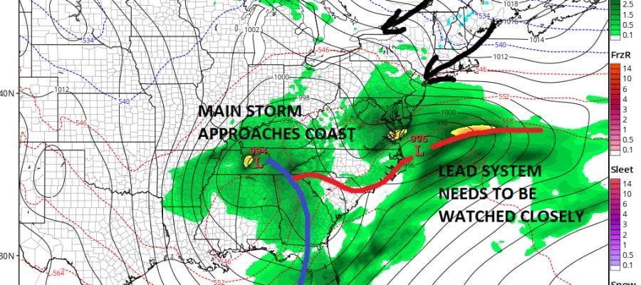
A few days ago we pointed out how some weather models specifically the Canadian model was draining cold air southward into a developing Noreaster. The model run seem pretty far fetched and an obvious long long long shot. It even seemed very far out there in the extreme. However the model did point out what has happening across Southeastern Canada with regards to a building blocking ridge. The idea would be that the ridge/block would be stronger keeping a high locked in over Labrador/SE Canada rather than taking the high out to the east. As we have drawn closer to the potential noreaster time frame, other models seem to be giving a similar idea though not to the extreme of that Canadian model view of a few days ago.
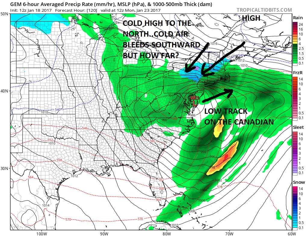
STORM THREAT CONTINUES, CANADIAN MODEL
Today’s model runs of the GFS and to a lesser extent the European open the door slightly wider especially for areas in the Hudson Valley, Northwest New Jersey, Northeast Pennsylvania and Northern Connecticut. The GFS was especially surprising to me on this notion because this model has been the warmest of all the models all along. However it has been trending colder and bleeding cold air further south with every run.
STORM THREAT CONTINUES GFS MODEL SUNDAY EVENING
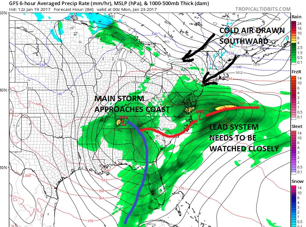
What is happening is that the models are showing a lead system ahead of the main storm off the Carolinas. That lead system moves northeast and while it weakens, it has enough of an identity that it allows the blocked high to the north to feed down colder air southwestward from Northern New England and Southeast Canada. Eventually the low in Central Tennessee reaches the coast and strengthens as it moves from North Carolina to just southeast of Nantucket by Tuesday.
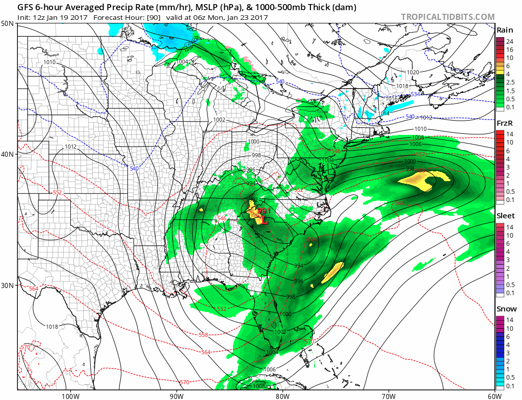
STORM THREAT CONTINUE SGFS MODEL SUNDAY NIGHT INTO TUESDAY MORNING CLICK TO ANIMATE
The European attempts to go in the same direction. The Canadian model has a similar idea but its not quite there yet with the other 2 models. The biggest issue here is that the magnitude of the cold air to the north is not enough to cause a problem. For this to be an important snow situation we would have to see the lead system do its job in a bigger way, and we also need to see the strong dynamics of the noreaster play out to a greater extreme. Both seem to be long shots to happen but now at least we can say it is certainly not impossible. The GFS generates a substantial amount of snow and extends it pretty far to the south. PLEASE NOTE THIS IS THE MODELS FORECAST AND NOT MINE.
GFS MODE SNOW FORECAST

CANADIAN MODEL SNOW FORECAST

The Canadian and European snow forecast maps look about the same. Right now we are going to leave this in the world of speculation and continue to watch where this all goes since frankly that’s all we can do. We can say that either way noreaster conditions continue to loom large from Delmarva to Cape Cod and this means heavy rains and very strong winds along the coast are likely from Sunday night into Tuesday morning. That part of the equation remains the same regardless of whether snow or sleet get involved. The GFS model trend has been colder on the last 4 runs. From here forward we will see if this trend continues. If the cold air becomes part of this scenario it would not be until later Monday into Monday night that it would be an issue. Sunday night into Monday morning its all rain regardless. Then we watch what happens after that.
MANY THANKS TO TROPICAL TIDBITS FOR THE WONDERFUL USE OF THE MAPS
SNOW REMOVAL COMPANIES FOR YOUR WINTER NEEDS
LONG ISLAND ROCKLAND COUNTY Connecticut

![]()

ROCKLAND COUNTY TRI STATE SNOW REMOVAL JOHNSTOWN PA


FiOS1 News Weather Forecast For Long Island
FiOS1 News Weather Forecast For New Jersey
FiOS1 News Weather Forecast For Hudson Valley
NATIONAL WEATHER SERVICE SNOW FORECASTS
LATEST JOESTRADAMUS ON THE LONG RANGE
Weather App

Don’t be without Meteorologist Joe Cioffi’s weather app. It is really a meteorologist app because you get my forecasts and my analysis and not some automated computer generated forecast based on the GFS model. This is why your app forecast changes every 6 hours. It is model driven with no human input at all. It gives you an icon, a temperature and no insight whatsoever.
It is a complete weather app to suit your forecast needs. All the weather information you need is right on your phone. Android or I-phone, use it to keep track of all the latest weather information and forecasts. This weather app is also free of advertising so you don’t have to worry about security issues with your device. An accurate forecast and no worries that your device is being compromised.
Use it in conjunction with my website and my facebook and twitter and you have complete weather coverage of all the latest weather and the long range outlook. The website has been redone and upgraded. Its easy to use and everything is archived so you can see how well Joe does or doesn’t do when it comes to forecasts and outlooks.
Just click on the google play button or the apple store button on the sidebar for my app which is on My Weather Concierge. Download the app for free. Subscribe to my forecasts on an ad free environment for just 99 cents a month.
Get my forecasts in the palm of your hand for less than the cost of a cup of Joe!
![]()
